
The USA has thousands of scenic day hikes and epic long distance hikes carving through national parks, state parks, forests, deserts, volcanoes and mountain ranges. But there’s a collection of notable hiking trails in the US that stand out above the rest for being especially beautiful or uniquely adventurous.
We’ve hiked some of the most amazing trails in more than 30 US states since we began traveling full time in 2018. Along with landscape photography, hiking is our favorite thing to do anytime we go somewhere new in America, so we usually plan our entire trips around hikes!
We’ve personally completed many of what we consider the best US hiking trails that we cover in this guide, including the likes of Angels Landing, The Wave, The Enchantments, Skyline Loop, The Narrows and South Kaibab to Bright Angel. Any trail in this list that we haven’t yet completed is there because it’s on our own hiking bucket list. Read more about us.
In this guide we show you 50 top rated hiking trails from around the US, based on the hikes we’ve done or really want to do. The list is in alphabetical order to keep things easy, and stick around until the end to see our personal top 10 USA hikes ranked. Let’s begin!
Note: This article may contain affiliate links. If you make a purchase using one of these affiliate links, we may earn a small commission at no extra cost to you. Thank you!
Trails Map
Click or touch the map below to activate, zoom in and out, and scroll around. If you’d like to see a bigger version, click the “view larger map” icon in the top right, and if you’d like to see any specific trail, click the arrow and square icon in the top left.
Map key:
- Blue – Easy trails
- Yellow – Moderate trails
- Red – Strenuous trails
- Purple – Extremely hard trails
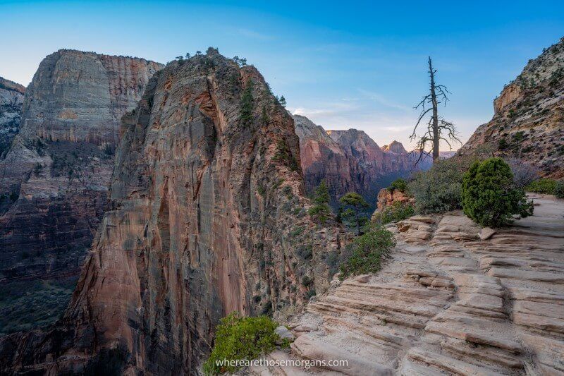
1. Angels Landing Trail
- Difficulty: Strenuous
- Distance: 5.4 miles roundtrip
- Elevation Gain: 1,488 feet
- Time: 3-4 hours
- Location: Springdale, UT
- Season: Year round
Angels Landing Trail is a wildly popular 5.4-mile roundtrip hike in Zion National Park. It’s one of the most famous adventure hikes in the US thanks to a razor thin rock climb with metal chains and long vertical drop-offs leading to dramatic views over Zion Canyon. A permit is required to climb from Scout Lookout to Angels Landing.
We’ve hiked Angels Landing twice. The first time was midday in October 2019 and the trail was packed full of hikers which made it a terrifying experience. So the second time we climbed to Angels Landing for sunrise in December and had the whole trail to ourselves. It’s a unique hike, but it’s not for the feint of heart!
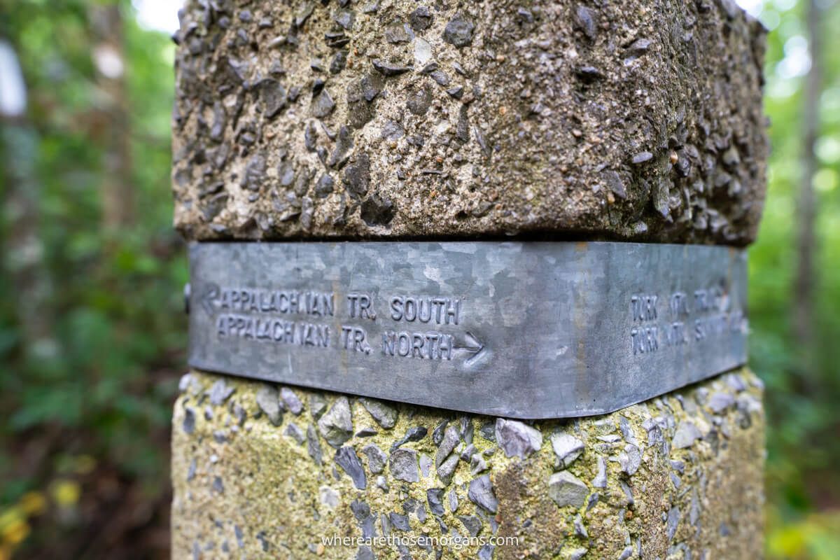
2. Appalachian Trail
- Difficulty: Very strenuous
- Distance: 2,198 miles
- Elevation Gain: ~500,000 feet
- Time: 5-7 months
- Terminus: North-Katahdin, Maine | South-Springer Mountain, Georgia
- Season: Year round
The Appalachian National Scenic Trail is a long distance hiking trail running from Springer Mountain in Georgia to Mount Katahdin in Maine. It takes around 5-7 months on average to hike 2,100 miles through 14 US states and complete this world famous trail.
Hiking the Appalachian Trail would test your physical and mental fortitude to the extreme. We’ve walked portions of the Appalachian Trail in Vermont, New Hampshire, Virginia and in the Smokies. But taking on the entire trail would be the hike of a lifetime.
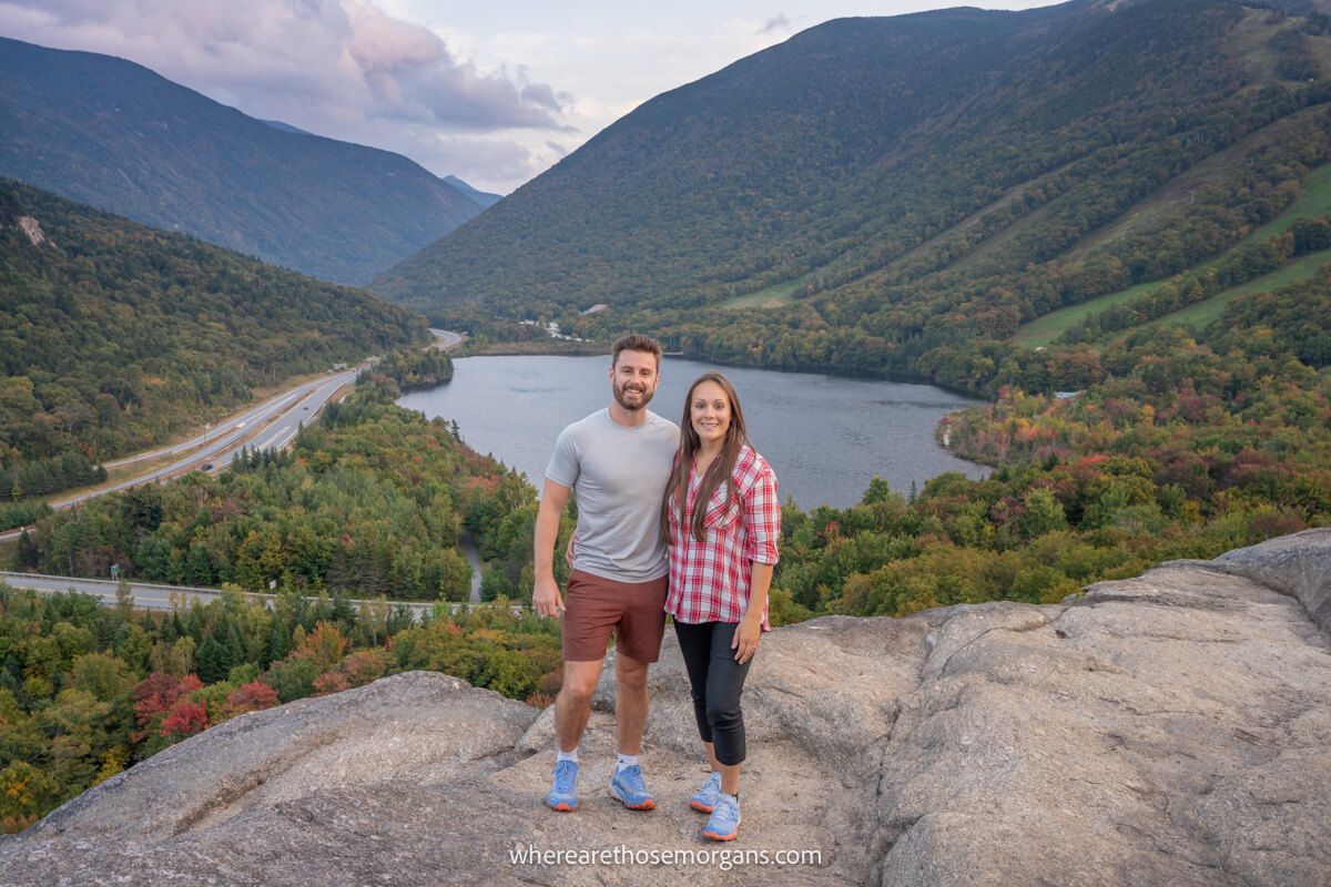
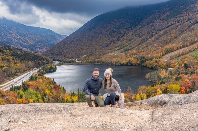
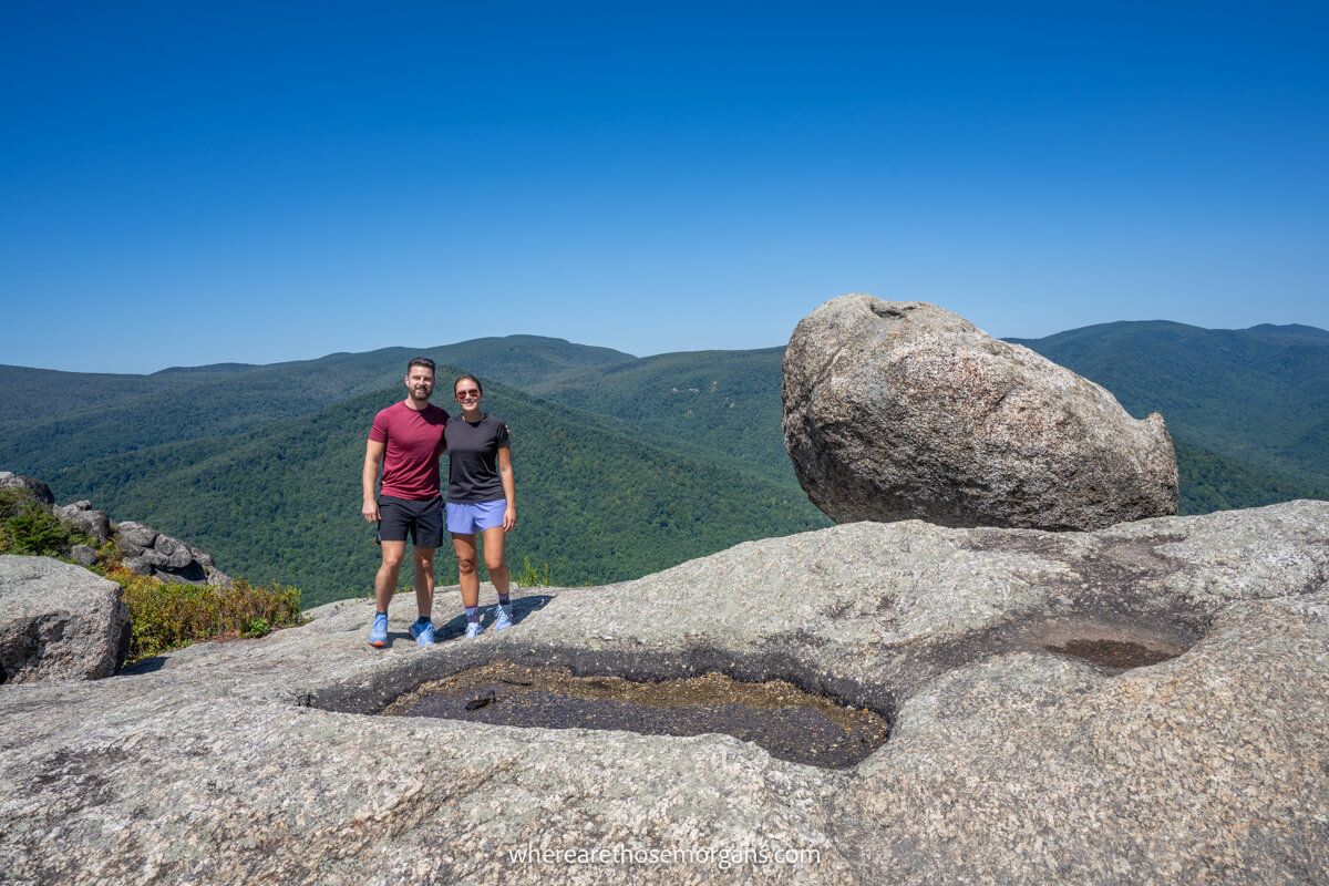
3. Artists Bluff Trail
- Difficulty: Easy
- Distance: 0.5 miles roundtrip
- Elevation Gain: 200 feet
- Time: 1.5-2 hours
- Location: Franconia, NH
- Season: Year round
Artists Bluff Trail is a short but steep 0.5-mile roundtrip hike in Franconia Notch State Park in New Hampshire. The trail can be hiked as a standalone or as a loop with Bald Mountain. Artists Bluff summit viewpoint has striking views over Echo Lake and it’s one of the most famous fall foliage photo spots.
We’ve hiked to Artists Bluff twice on separate New England fall foliage road trip routes in 2019 and 2023. It’s one of the most rewarding easy trails you can do in New England, especially when combined with Bald Mountain which also has dramatic views. Add this trail to your US hiking bucket list.
4. Black Elk Peak Trail
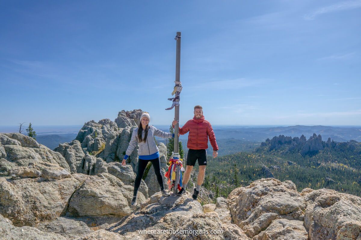
- Difficulty: Moderate
- Distance: 7 miles roundtrip
- Elevation Gain: 1,500 feet
- Time: 4-5 hours
- Location: Custer, SD
- Season: Year round
Black Elk Peak Trail summit is the highest point in South Dakota’s Black Hills at 7,242 feet. There are several routes leading to Black Elk Peak but the most popular route is to park at Sylvan Lake and take trail #9 up then trail #4 down. The summit provides views into South Dakota, Wyoming, Montana and Nebraska.
Hiking to Black Elk Peak was the best part of our first South Dakota road trip in October 2019. The trail is fun, family friendly and incredibly scenic. Don’t miss this hike when you visit the Black Hills and go at the beginning of October to see golden leaves mixing with emerald greens and granite grey rocks.
5. Cascade Canyon Trail
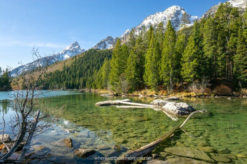
- Difficulty: Strenuous
- Distance: 9.4 miles roundtrip
- Elevation Gain: 1,480 feet
- Time: 5-9 hours
- Location: Jackson, WY
- Season: Summer, Fall
The Cascade Canyon Trail is a moderately strenuous 9.4-mile roundtrip hike with a boat ride and a total elevation gain of 1,480 feet in Grand Teton National Park, Wyoming. Hiking this trail without the paid boat ride across Jenny Lake increases difficulty, length and elevation gain.
Cascade Canyon is the best hike in Grand Teton. It begins with a climb to Hidden Falls and Inspiration Point, before following Cascade Creek through a u-shaped canyon with striking views over snow capped mountains and an abundance of wildlife. Don’t miss this amazing US hike next time you’re in Wyoming.
6. Cathedral Rock Trail
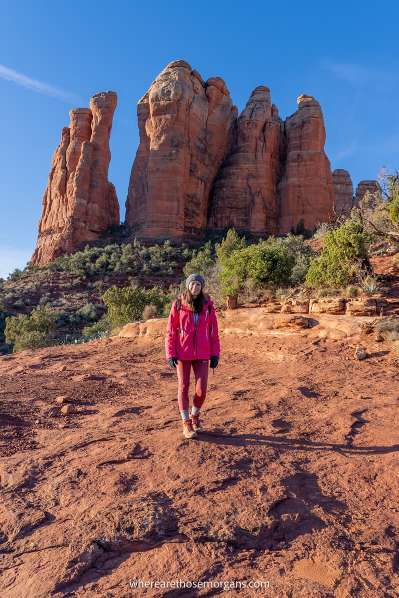
- Difficulty: Moderate
- Distance: 1.2 miles roundtrip
- Elevation Gain: 700 feet
- Time: 2 hours
- Location: Sedona, AZ
- Season: Year round
Cathedral Rock Trail is a moderately difficult 1.2-mile roundtrip hike in Sedona, Arizona. It’s a short but steep trail leading directly up slick rock to two summit viewpoints hidden behind tall sandstone spires. Cathedral Rock is among the most popular hikes in Sedona.
We hiked Cathedral Rock Trail to summit in time for sunrise and it was an amazing experience. Sedona is one of the best places to visit in Arizona and scenic red rock trails like Cathedral Rock are at the heart of its popularity. This is a hike you simply can’t miss in Sedona.
7. Continental Divide Trail
- Difficulty: Very strenuous
- Distance: 3,100 miles
- Elevation Gain: ~ 450,000 feet
- Time: 5-6 months
- Terminus: North – Glacier National Park, MT | South – Crazy Cook Monument, NM
- Season: April-October
The Continental Divide Trail is a 3,100 mile hike running from the Mexican border to the Canadian border in Glacier National Park. It’s the highest and most isolated multi-month hike in the US, passing through New Mexico, Colorado, Wyoming, Idaho and Montana.
Hiking the Continental Divide Trail would be the ultimate immersive wilderness experience. There’s grizzly bears, wolves, mountain lions, landslides, floods and unfinished sections of the route to contend with.
8. Delicate Arch Trail
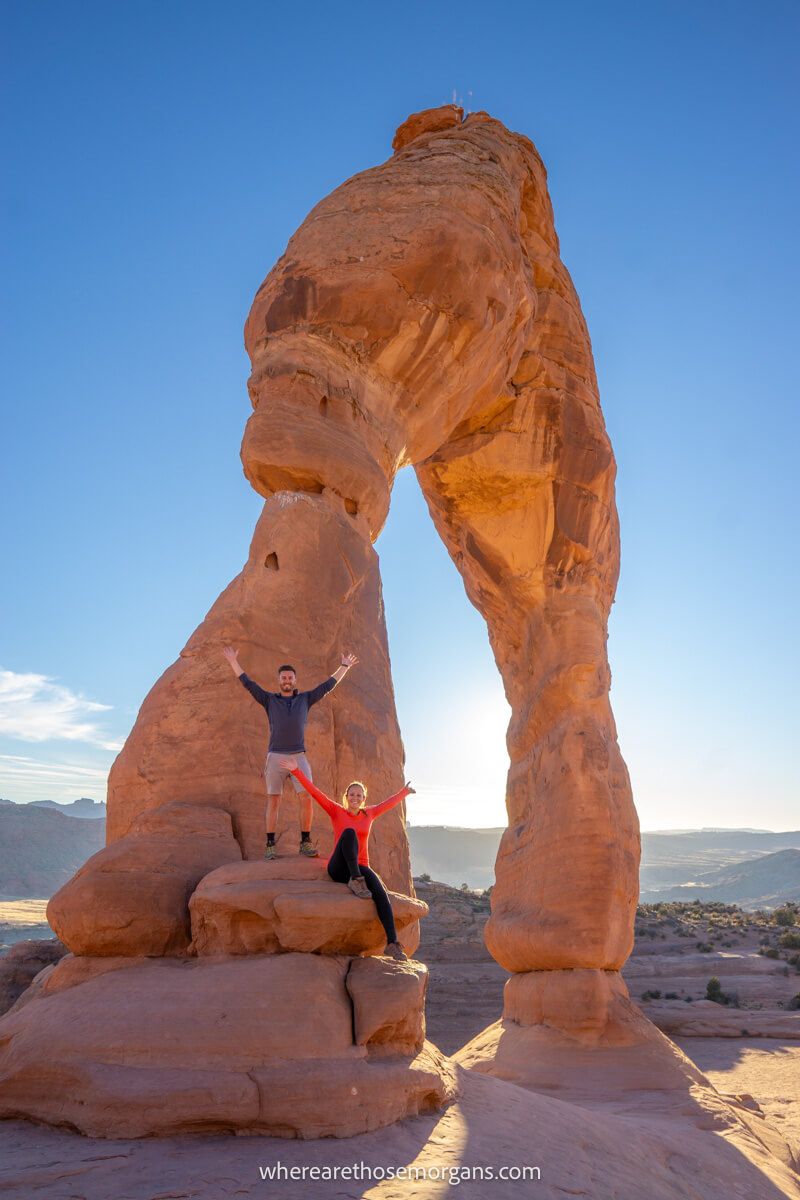
- Difficulty: Moderate
- Distance: 3 miles roundtrip
- Elevation Gain: 480 feet
- Time: 2-3 hours
- Location: Moab, UT
- Season: Year round
Delicate Arch Trail is a moderately difficult 3-mile roundtrip hike in Arches National Park, Utah. It has a total elevation gain of 480 feet and takes around 2-3 hours to complete. The slickrock trail leads to a massive sandstone arch formation and a deep bowl-shaped depression.
We hiked to Delicate Arch for sunset during our trip to Arches in November 2019. It’s a totally unique landscape and as travel photographers we think watching the sun setting over Delicate Arch is one of the places you can’t miss in Utah. The hike is fun but the summit views make this one so special.
9. Devils Garden Trail
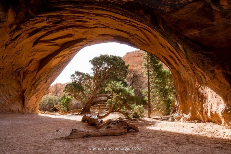
- Difficulty: Strenuous
- Distance: 7.9 miles roundtrip
- Elevation Gain: 1,000 feet
- Time: 3-4 hours
- Location: Moab, UT
- Season: Year round
The Devils Garden Trail is a challenging 7.9-mile primitive loop hike leading to seven arches and one 125-foot tall spire in Arches National Park in Utah. Beginners can walk to Landscape Arch, advanced hikers can hike to Double O Arch and experienced hikers can complete the full unmaintained loop.
We hiked the awesome Devils Garden Trail in November 2019. It has a unique lost world feel with elements of pathfinding and forging paths involved. There aren’t many unmaintained trails in the US like this one. For us, it’s one of the top hikes in Arches National Park.
10. Emerald Lake Trail
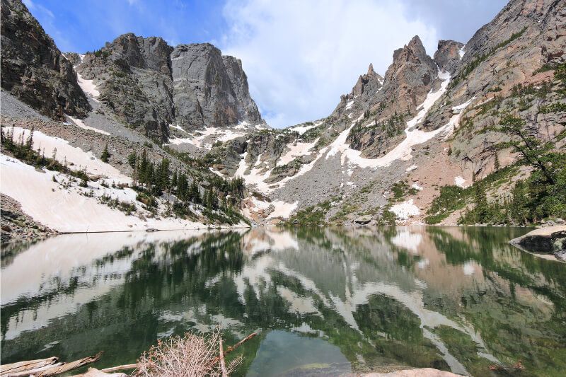
- Difficulty: Moderate
- Distance: 4.1 miles roundtrip
- Elevation Gain: 744 feet
- Time: 2-3 hours
- Location: Estes Park, CO
- Season: Year round
The Emerald Lake Trail in Rocky Mountain National Park is a 4.1-mile roundtrip hike with a total elevation gain of 744 feet. Beginning at Bear Lake, the trail passes by Nymph Lake and Dream Lake before arriving at the picture-perfect Emerald Lake.
Rocky Mountain National Park is home to countless miles of beautiful scenery with snow capped mountain peaks and brilliant blue lakes at every turn, but Emerald Lake might just be the best of the bunch.
11. Fire Wave Trail
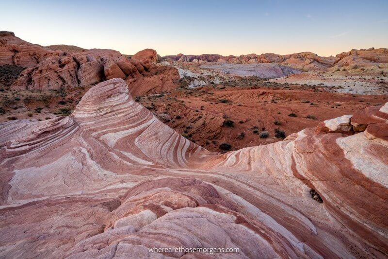
- Difficulty: Easy
- Distance: 1.5 miles roundtrip
- Elevation Gain: 175 feet
- Time: 1-2 hours
- Location: Overton, NV
- Season: Fall, Winter, Spring
Fire Wave Trail is an easy 1.5-mile roundtrip hike over sand and red rocks leading to striking sandstone formations with swirling red, white and pink patterns. It’s fun, family friendly and our favorite trail by far in Valley of Fire State Park.
We hiked to the Fire Wave for sunrise and had the alien landscape entirely to ourselves. It’s unique, exceptionally photogenic and easy to visit on a day trip from Las Vegas. We highly recommend stopping at Valley of Fire to walk Fire Wave Trail if you’ll be driving between Las Vegas and Zion.
12. Guadalupe Peak Trail
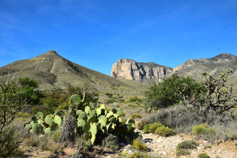
- Difficulty: Strenuous
- Distance: 8.4 miles roundtrip
- Elevation Gain: 3,000 feet
- Time: 6-8 hours
- Location: Pine Springs, TX
- Season: Year round
The Guadalupe Peak Trail is a strenuous 8.4-mile roundtrip hike to the highest natural point in Texas in Guadalupe Mountains National Park. It has a total elevation gain of 3,000 feet and a summit elevation of 8,751 feet.
It takes around six to eights hours to complete the Guadalupe Peak Trail hike. But it’s well worth the effort to enjoy far reaching summit views from the Top of Texas.
13. Golden Canyon Trail
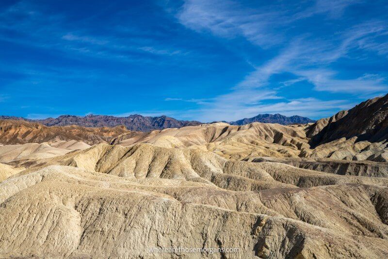
- Difficulty: Strenuous
- Distance: 7.8 miles roundtrip
- Elevation Gain: 834 feet
- Time: 4-5 hours
- Location: Furnace Creek, CA
- Season: Fall, Winter, Spring
The Golden Canyon Trail is a strenuous 7.8-mile roundtrip loop hike in Death Valley National Park. It can be hiked in several ways to suit ability but the full circuit passes by Red Cathedral, Zabriskie Point, Badlands Loop and Gower Gulch.
We hiked Golden Canyon Trail in December 2021 on a hot and completely exposed day. It’s a fantastic trail with lots of cool photo stops but it’s important to carry plenty of water to stay hydrated.
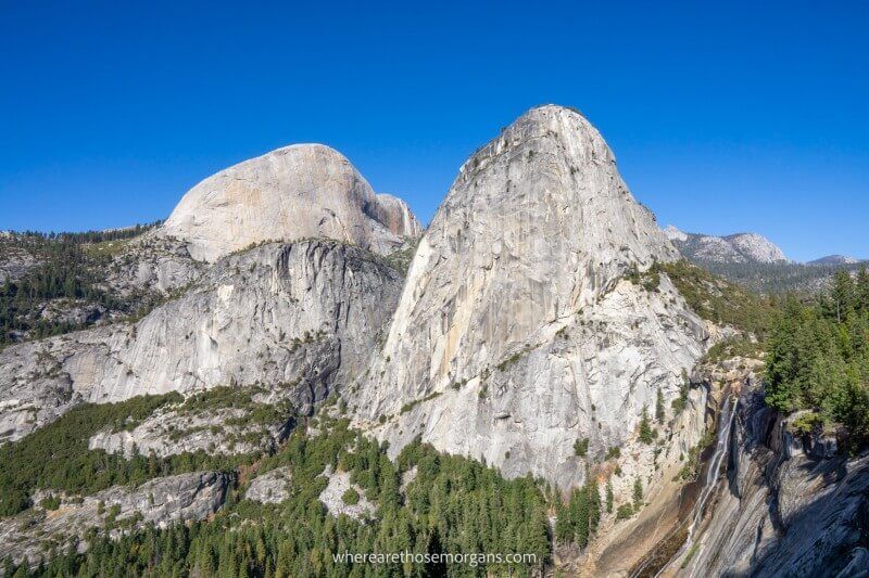
14. Half Dome Trail
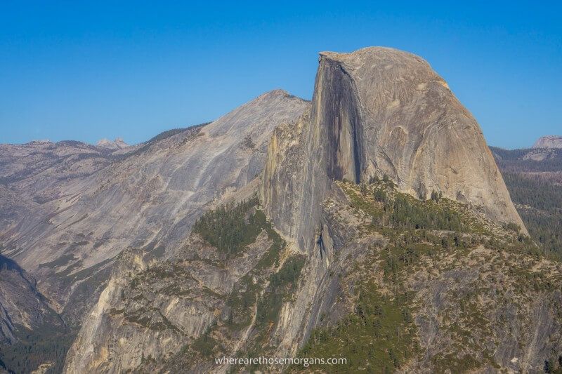
- Difficulty: Strenuous
- Distance: 14-16 miles roundtrip
- Elevation Gain: 4,800 feet
- Time: 10-12 hours
- Location: Yosemite Valley, CA
- Season: Late May-Mid October
The Half Dome Trail is a very strenuous 14-16 mile roundtrip day hike in Yosemite National Park, California. It has a total elevation gain of 4,800 feet and it should only be attempted by strong hikers. A permit is required to begin climbing the steep cables section to Half Dome summit.
We’ve applied for Half Dome permits 5 years in a row and still haven’t won one yet! It’s one of the most sought after day hikes in the US so you’ll need a bit of luck in the lottery. We have hiked Mist Trail and John Muir Trail which descends back to Yosemite Valley and they’re both awesome.
15. Highline Trail
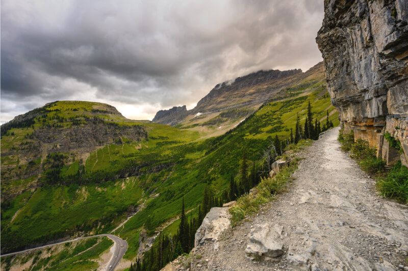
- Difficulty: Strenuous
- Distance: 11.6 miles one-way
- Elevation Gain: Gain – 800 feet / Loss – 3,000 feet
- Time: 5-7 hours
- Location: St Mary, MT
- Season: July-October
The Highline Trail is a challenging 11.6 mile one-way hike in Glacier National Park, Montana. It has a total elevation gain of around 800 feet and a total elevation loss of around 3,000 feet. The easiest way to hike Highline Trail is to park at The Loop, take a free shuttle to Logan Pass and walk back to The Loop.
It follows a section of the Continental Divide Trail and has some of the most visually stunning views of any day hike in the US as it tracks high up above Glacier’s Going-to-the-Sun road.
16. Hollywood Sign Trail

- Difficulty: Moderate
- Distance: 3 miles roundtrip
- Elevation Gain: 875 feet
- Time: 2 hours
- Location: Los Angeles
- Season: Year round
The Hollywood Sign is located on the southern slope of Mount Lee in Griffith Park, Los Angeles. There are several trails leading to the Hollywood Sign, but the quickest and most direct route is Cahuenga Peak and Mount Lee via Burbank Peak Trail and Aileen Getty Ridge Trail.
We hiked this short route from Lake Hollywood Drive to the back of the Hollywood Sign on a blazing hot day in November 2019. It’s definitely one of the things you can’t miss on a first visit to LA, not just for the sign but also for the spectacular views overlooking the entire valley.
17. John Muir Trail
- Difficulty: Very strenuous
- Distance: 211 miles
- Elevation Gain: 47,000 feet
- Time: 3 weeks
- Terminus: North-Happy Isles, CA | South-Mount Whitney Summit, CA
- Season: July-September
The John Muir Trail is a 211-mile hike running from Yosemite Valley to Mount Whitney in California’s Sierra Nevada Mountains. It passes through Yosemite, Sequoia and Kings Canyon National Parks before ending at the highest peak in the continental United States.
Following the southern portion of the celebrated Pacific Crest Trail for much of its total distance, the John Muir Trail has some of America’s most dramatic views of 13,000-14,000 foot mountains and it can be completed in just 2-3 weeks.
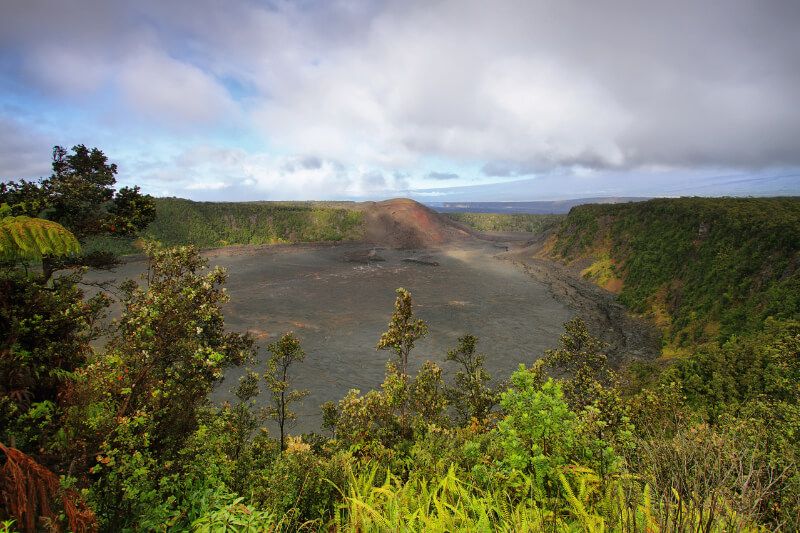
18. Kilauea Iki Trail
- Difficulty: Moderate
- Distance: 4 miles roundtrip
- Elevation Gain: 400 feet
- Time: 2-4 hours
- Location: Volcano, HI
- Season: Year round
Kilauea Iki is a pit crater in Hawaii Volcanoes National Park. The Kilauea Iki Trail and Crater Rim Trail is a moderately difficult 4-mile roundtrip loop hike combining the northern crater rim and the crater floor. A spur loop trail leading through Nahuku-Thurston Lava Tube should be included to the hike.
Hiking across 65 year old lava on top of an active volcano with steam billowing through cracks is a unique experience that can’t be missed on a visit to Hawaii. The Kilauea Iki Trail has to be considered as one of the top bucket list US hikes.
19. Lost Mine Trail
- Difficulty: Moderate
- Distance: 4.8 miles roundtrip
- Elevation Gain: 1,100 feet
- Time: 3 hours
- Location: Terlingua, TX
- Season: Year round
The Lost Mine Trail is a moderately difficult 4.8-mile roundtrip hike in Big Bend National Park in Texas. It’s an alpine hike full of juniper trees and pine trees with superb views over surrounding mountains and desert.
Lost Mine is the most popular trail in Big Bend and it has near perfect reviews from thousands of previous hikers. This is a US hike you shouldn’t miss if you’re passing through southwest Texas.
20. Maple Pass Loop Trail

- Difficulty: Strenuous
- Distance: 7.2 miles roundtrip
- Elevation Gain: 2,000 feet
- Time: 4-5 hours
- Location: Winthrop, WA
- Season: May-November
The Maple Pass Loop Trail is a challenging 7.2-mile roundtrip loop hike in North Cascades National Park, Washington. It has a total elevation gain of 2,000 feet and can be hiked in either direction, but counterclockwise has a more gradual ascent and better views of Black Peak at Maple Pass.
We hiked Maple Pass Loop in September 2021 and it’s one of our personal favorite hiking trails in the US. The ascent is grueling but the views over Ann Lake and the Cascade Mountains are beautiful. It’s easily one of the most photogenic trails we’ve hiked in America.
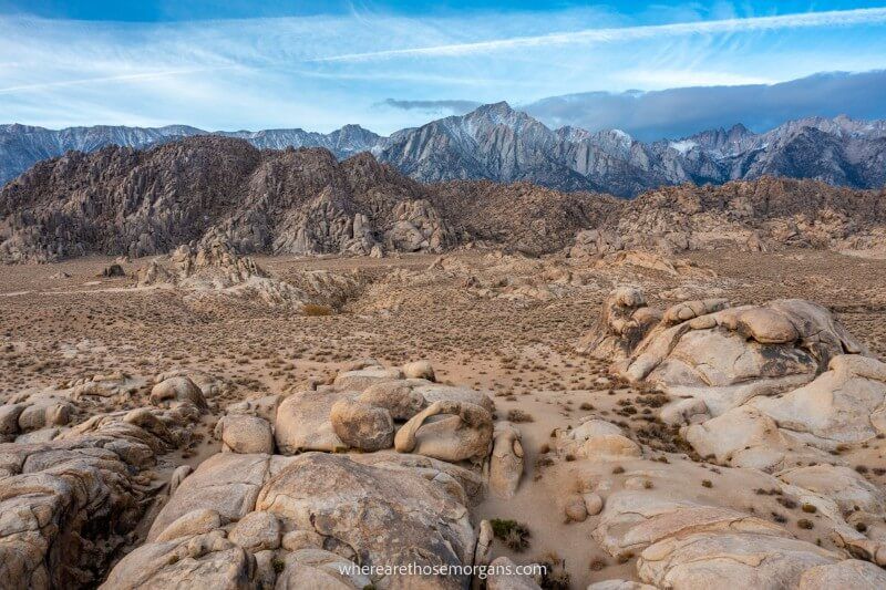
21. Mobius Arch Loop Trail
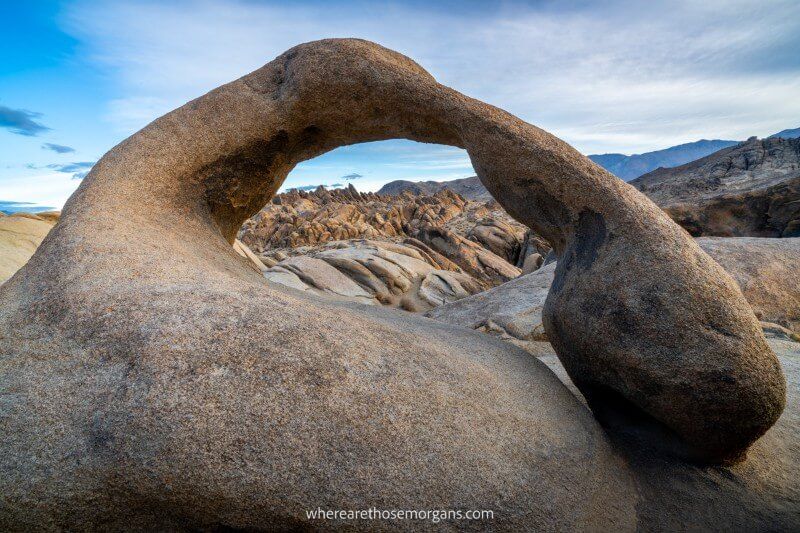
- Difficulty: Easy
- Distance: 0.6 miles roundtrip
- Elevation Gain: 50 feet
- Time: 1-2 hours
- Location: Lone Pine, CA
- Season: Year round
The Mobius Arch Loop Trail is an easy 0.6-mile roundtrip loop hike in the Alabama Hills, California. The Alabama Hills are located along Movie Flat Road close to Lone Pine with a backdrop of the Sierra Nevada Mountains and Mt Whitney.
We hiked to Mobius Arch for sunrise in November 2021. Unfortunately, the sunrise was a little flat but the trail was still fun and photogenic. We think Mobius Arch is one of the best hidden gem US hikes for photographers because very few know about the dramatic Alabama Hills landscape.
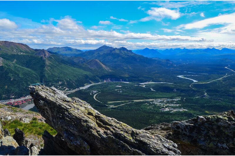
22. Mount Healy Overlook Trail
- Difficulty: Strenuous
- Distance: 5.4 miles roundtrip
- Elevation Gain: 1,700 feet
- Time: 3-4 hours
- Location: Healy, AK
- Season: Late Spring, Summer
Mount Healy Overlook Trail is a challenging 5.4-mile roundtrip hike in Denali National Park, Alaska. It’s one of the steepest hikes in Denali but it ends at an overlook with panoramic views. It’s always windy at the overlook and the weather can quickly take a turn for the worse.
The trail passes through spruce forest and tundra before turning steep to the viewpoint. Strong hikers can continue beyond the overlook to gain more elevation on Mount Healy and open up views of Denali on a clear day.
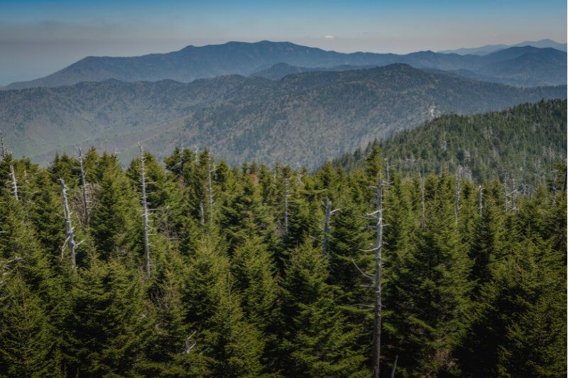
23. Mount LeConte (Alum Cave Trail)
- Difficulty: Strenuous
- Distance: 11 miles roundtrip
- Elevation Gain: 2,750 feet
- Time: 6-9 hours
- Location: Gatlinburg, TN
- Season: April-November
Mount Leconte is the third highest peak in Great Smoky Mountains National Park. There are six trails leading to Mount LeConte summit but the challenging 11-mile roundtrip hike on Alum Cave Trail is the shortest, steepest and most popular route.
The hike passes by Arch Rock, Inspiration Point and Alum Cave Bluff on the way to summiting Mount LeConte. It’s worth continuing a short distance further for quintessential views overlooking the Smokies from Myrtle Point.
24. Mount Marcy (Van Hoevenberg Trail)
- Difficulty: Strenuous
- Distance: 14.8 miles roundtrip
- Elevation Gain: 3,150 feet
- Time: 7-11 hours
- Location: Lake Placid, NY
- Season: Year round
Mount Marcy Trail leads to the highest point in New York State at 5,343 feet. It’s located in the Adirondack Mountains near Lake Placid and the challenging 14.8-mile roundtrip hike on the Van Hoevenberg Trail is the most popular route to Mt Marcy summit.
We hiked Van Hoevenberg Trail to Mount Marcy in October 2020. It’s a long, slow, wet, muddy and grueling trail mostly through forest but it’s all worth it for 360 degree summit views over rolling Adirondack hills as far as the eye can see.
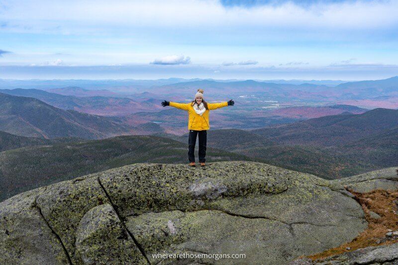
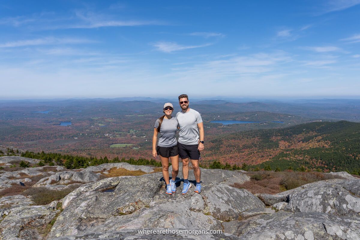
25. Mount Monadnock Trail
- Difficulty: Strenuous
- Distance: 3.9 miles roundtrip
- Elevation Gain: 1,500 feet
- Time: 3-5 hours
- Location: Jaffrey, NH
- Season: April-November
Mount Monadnock in New Hampshire has many hiking trails ranging in length and difficulty to the summit. The most popular hike to Mt Monadnock summit is a challenging 3.9-mile roundtrip loop trail ascending on the White Dot Trail and descending on the White Cross Trail.
We hiked Mount Monadnock via White Dot and White Cross in October 2023 and it turned out to be one of our favorite hikes in the USA. The steep trail has fun rock scrambles and exceptional 360 degree summit views. Don’t miss this one the next time you’re in New Hampshire!
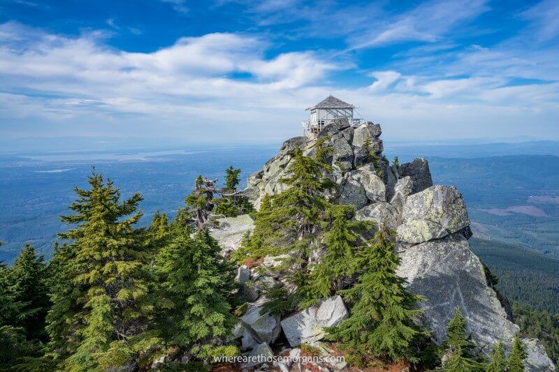
26. Mount Pilchuck Trail
- Difficulty: Strenuous
- Distance: 5.4 miles roundtrip
- Elevation Gain: 2,100 feet
- Time: 4 hours
- Location: Granite Falls, WA
- Season: June-October
Mount Pilchuck Trail leads to a 5,344 foot tall mountain summit in Mount Baker-Snoqualmie National Forest, Washington. The trail ends at a unique wooden fire lookout tower, but it’s a challenging 5.4-mile roundtrip hike with a total elevation gain of 2,100 feet.
We hiked to Mt Pilchuck summit in August 2021. It was one of our favorite hikes in Washington, and we completed a lot of trails in 6 months living near Seattle! The access road is terrible with lots of potholes, but the trail is fun and the summit views from the fire lookout tower are outstanding.
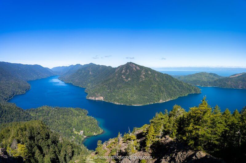
27. Mount Storm King Trail
- Difficulty: Strenuous
- Distance: 4 miles roundtrip
- Elevation Gain: 2,050 feet
- Time: 3-4 hours
- Location: Port Angeles, WA
- Season: May-October
Mount Storm King Trail is a challenging 4-mile roundtrip hike in Olympic National Park, Washington. It’s a short but grueling trail gaining over 2,000 feet elevation including a rope section. Views over the central Olympics and Lake Crescent are spectacular.
We hiked Mt Storm King in July 2021 on a beautiful and clear day. The trail is renowned for being overcrowded but it’s worth putting up with the crowds for the mesmerizing views you’ll get at the top. This trail should be on your US hiking bucket list if you plan to visit Olympic soon.
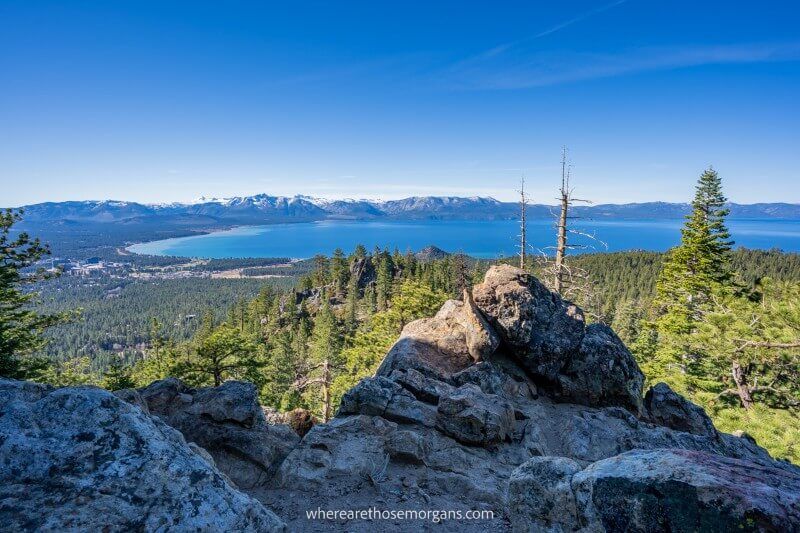
28. Mount Tallac Trail
- Difficulty: Strenuous
- Distance: 10 miles roundtrip
- Elevation Gain: 3,300 feet
- Time: 6-8 hours
- Location: South Lake Tahoe
- Season: Summer, Fall
At 9,738 feet, Mount Tallac is the tallest mountain on Lake Tahoe’s shoreline. The Mount Tallac Trail is a challenging 10-mile roundtrip hike beginning just 3.5 miles west of South Lake Tahoe. It’s an exceptionally scenic hike with lakes, forests and sweeping summit views.
We’ve hiked many trails around Lake Tahoe and the views are always magnificent. But Mt Tallac has some of the best on offer. You’ll see Fallen Leaf Lake, Floating Island Lake, Cathedral Lake, Cascade Lake, Emerald Bay and of course Lake Tahoe.
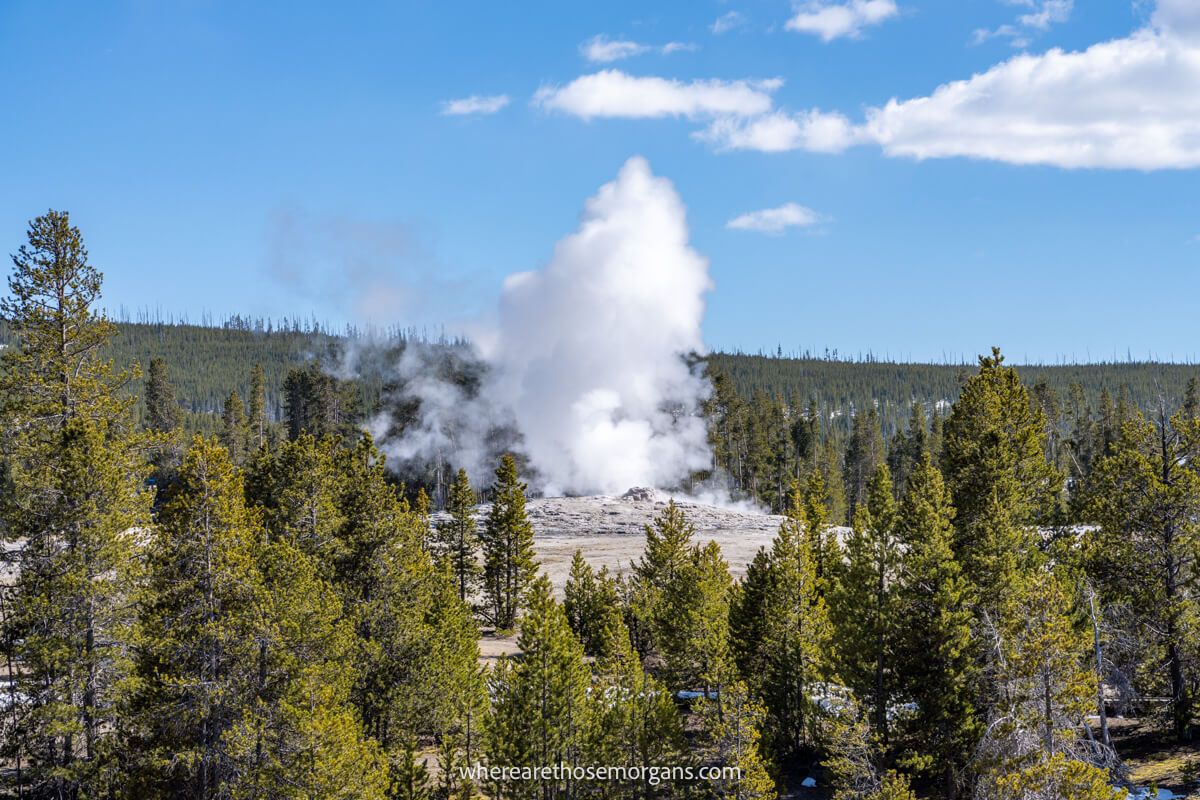
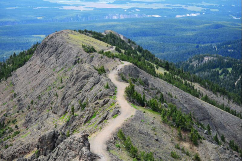
29. Mount Washburn Trail
- Difficulty: Moderate
- Distance: 6 miles roundtrip
- Elevation Gain: 1,500 feet
- Time: 4-5 hours
- Location: West Yellowstone, MT
- Season: Summer, Fall
Mount Washburn Trail is a popular day hike in Yellowstone National Park. A shorter version can be walked from Chittenden Road but the best way to hike to Mt Washburn is from Dunraven Pass Trailhead. The gradual climb from Dunraven Pass leads to the 10,219 foot high summit and far reaching views.
We’ve been to Yellowstone in April and October and both times Mt Washburn Trail was inaccessible due to snow. It’s the most popular day hike in the park and it should be on your Yellowstone itinerary. From the summit you can see up to 50 miles away on a clear day.
30. Mount Washington Trail
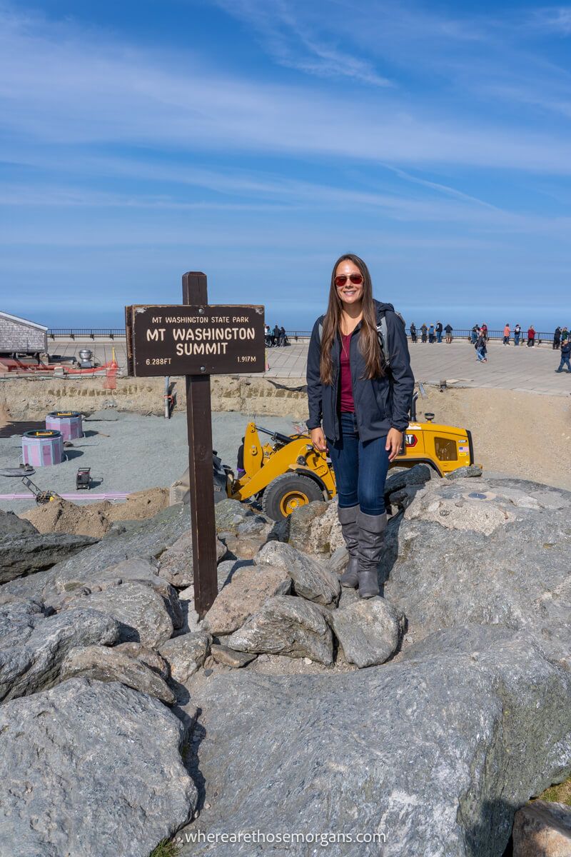
- Difficulty: Strenuous
- Distance: 8.2 miles roundtrip
- Elevation Gain: 4,200 feet
- Time: 6-9 hours
- Location: Gorham, NH
- Season: Summer, Fall
At 6,288 feet, Mount Washington is the tallest peak in New Hampshire and the highest point in New England. It has the highest wind speed ever recorded in the US at 237mph and has been called the world’s most dangerous small mountain. You can hike, drive or take a cog train to the summit.
We drove to Mt Washington summit on a clear day in October 2023. But next time we’ll hike the challenging 8.2-mile roundtrip Tuckerman Ravine Trail. It’s the most popular hiking route to Mount Washington summit, but it should only be attempted by strong hikers in good conditions.
31. Mount Whitney Trail
- Difficulty: Strenuous
- Distance: 22 miles roundtrip
- Elevation Gain: 6,100 feet
- Time: 12-16 hours
- Location: Lone Pine, CA
- Season: May-October
Mount Whitney Trail is a strenuous 22-mile roundtrip day hike to the summit of the tallest peak in the lower 48 states of America. Beginning at Whitney Portal near Lone Pine CA, the grueling hike has a total elevation gain of 6,100 feet and summits at 14,508 feet above sea level.
Hiking Mt Whitney requires a permit and it should only be attempted by experienced hikers. But if you’re looking for the toughest day hikes in the US, they don’t come any more challenging than this.
32. Multnomah Falls Trail
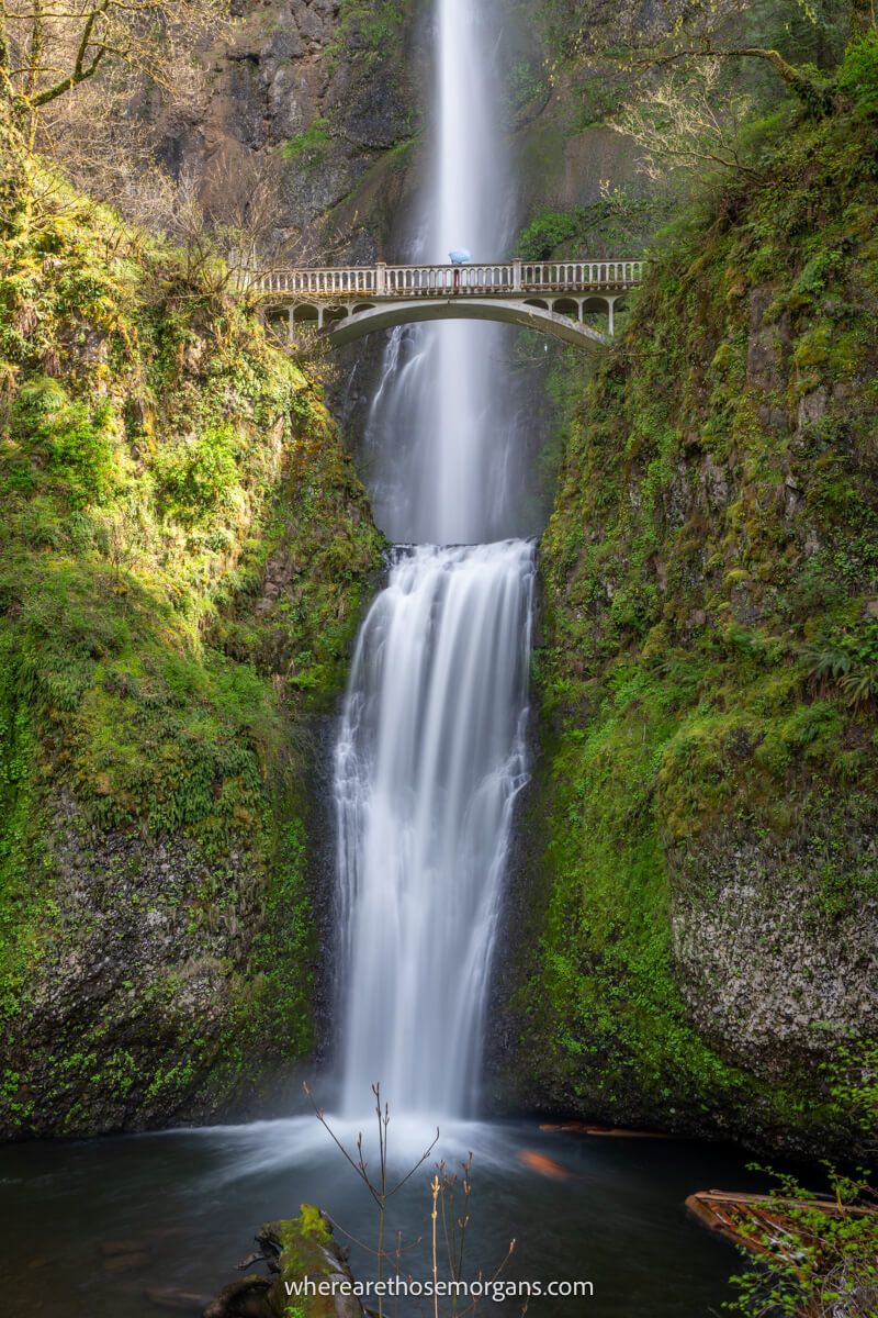
- Difficulty: Moderate
- Distance: 6 miles roundtrip
- Elevation Gain: 1,400 feet
- Time: 4 hours
- Location: Portland, OR
- Season: Year round
Multnomah Falls is a popular 620-foot waterfall in the Columbia River Gorge, Oregon. It’s the most visited natural attraction in the Pacific Northwest. There are several hiking options around Multnomah Falls but the best is the Wakheena Falls, Ecola Falls and Multnomah Falls Loop Trail.
We hiked the loop trail clockwise in September 2022. Getting to the top of Multnomah Falls is a thigh burner but it’s well worth it for the 3 hidden waterfalls before turning off to descend via Wakheena Falls. This complete loop is one of the best hikes in the Columbia River Gorge, so don’t miss it!
33. Notch Trail
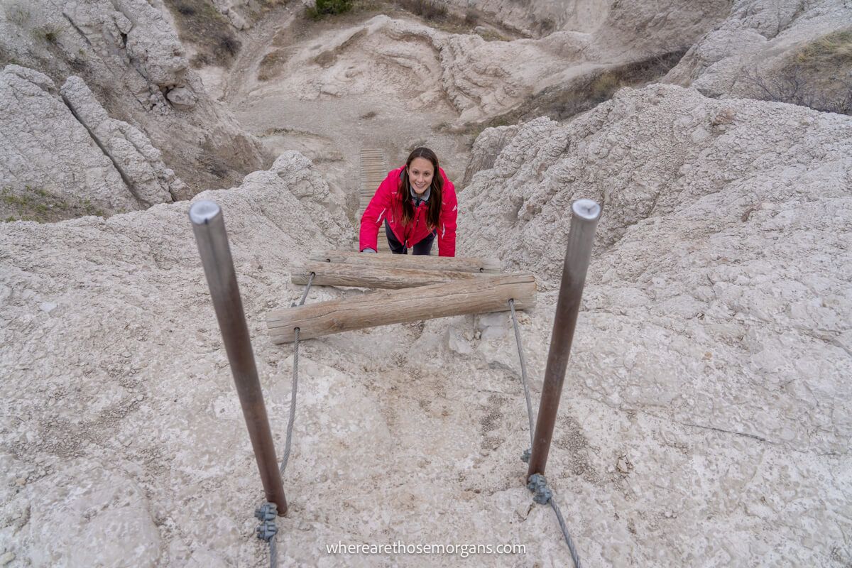
- Difficulty: Moderate
- Distance: 1.3 miles roundtrip
- Elevation Gain: 130 feet
- Time: 2 hours
- Location: Wall, SD
- Season: Year round
The Notch Trail is a moderately difficult 1.5-mile roundtrip hike with a fun ladder climb and excellent views. It cuts through a tall and rugged rock wall, skirts narrow cliff ledges and leads to a far reaching views over Badlands National Park from a trail end overlook.
We’ve hiked Notch Trail twice and both times had it to ourselves because we visited in the off season. It’s definitely the top hike to do in Badlands so prioritize this trail when you visit the park. The ladder section is unique and the landscape is photogenic so don’t forget your camera!
34. Old Rag Trail
- Difficulty: Strenuous
- Distance: 9.4 miles roundtrip
- Elevation Gain: 2,348 feet
- Time: 5-7 hours
- Location: Nethers, VA
- Season: May-October
Old Rag Circuit, also known as Old Rag Mountain Loop Trail, is a challenging 9.4-mile roundtrip loop hike in Shenandoah National Park, Virginia. The hike features extensive rock scramble sections on the ascent and Old Rag summit has beautiful 360 degree views.
We hiked Old Rag Trail in October 2023 on a warm and sunny day. It’s one of our favorite adventure hikes in the US and we’d say it’s worth visiting Shenandoah for this trail alone. You’ll need a permit, good shoes and plenty of water.
35. Pacific Crest Trail
- Difficulty: Very strenuous
- Distance: 2,650 miles roundtrip
- Elevation Gain: ~420,000 feet
- Time: 5 months
- Terminus: North-PCT Northern Terminus, WA | South-Campo, CA
- Season: Northbound start April-May | Southbound start June-July
The Pacific Crest Trail is a famous long distance US hiking trail running from Campo, California on the Mexican border to Manning Park, British Columbia on the Canadian border. It’s a 2,650-mile hike passing through the Sierra Nevada and Cascade mountain ranges in California, Oregon and Washington.
We’ve hiked sections of the PCT in Yosemite, Mt Rainier and North Cascades. It has the most dramatic and striking scenery of the three major long distance trails in America. This would be the first (and maybe only!) multi-month US hike we would do.
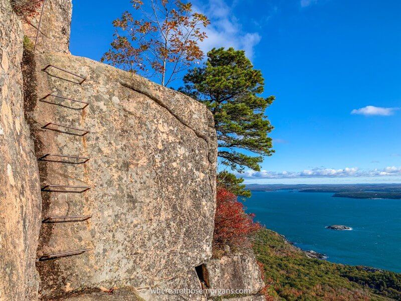
36. Precipice Trail
- Difficulty: Strenuous
- Distance: 3.2 miles roundtrip
- Elevation Gain: 1,050 feet
- Time: 2-3 hours
- Location: Bar Harbor, ME
- Season: May-October
The Precipice Trail is a challenging 3.2-mile roundtrip loop hike with more than 1,000 feet elevation gain in the first mile exclusively on steep cliffs, narrow ledges, iron rungs and metal ladders. It’s incredibly popular because it’s the most adventurous hiking trail in Acadia.
We hiked Precipice Trail on a beautiful fall day in October 2019, it was a fun and exhilarating climb that should definitely be on your US hiking bucket list. Our advice is to climb the smaller but similar Beehive Trail first before taking on Precipice Trail to get a feel for heights and climbing iron rungs.
- Difficulty: Moderate
- Distance: 2.9 miles roundtrip
- Elevation Gain: 625 feet
- Time: 2 hours
- Location: Bryce Canyon City, UT
- Season: Year round
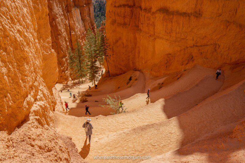
Queens Garden Navajo Loop Trail is a moderately difficult 2.9-mile roundtrip loop hike in Bryce Canyon National Park, Utah. It can be hiked in either direction going down into the photogenic amphitheater between sunrise point and sunset point along the 8,000-foot high rim.
We hiked Queens Garden Navajo Loop Trail clockwise in November 2019 from sunrise point to sunset point, and it was one of our favorite hikes in Utah. The unique trail cuts through eerie hoodoos and narrow sandstone walls before ascending out of the amphitheater via a series of sandy switchbacks.
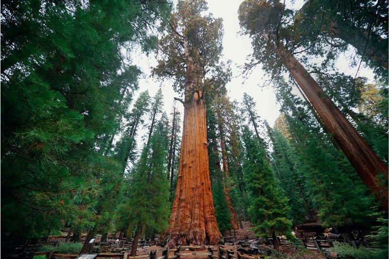
38. Giant Forest Loop Trail
- Difficulty: Moderate
- Distance: 7 miles roundtrip
- Elevation Gain: 600 feet
- Time: 3-4 hours
- Location: Three Rivers, CA
- Season: Year round
The Giant Forest Loop Trail is a moderately difficult 7-mile roundtrip loop hike in Sequoia-Kings Canyon National Park, California. It passes through the Giant Forest Grove which contains the world’s largest trees, including General Sherman.
The trail can be hiked in many ways but the best route is Sherman Tree, Congress, Trail of the Sequoias and Tharp’s Log. However, beginners can hike a much shorter and easier 1.2-mile roundtrip trail with just 200 feet elevation gain straight to the General Sherman Tree and back.
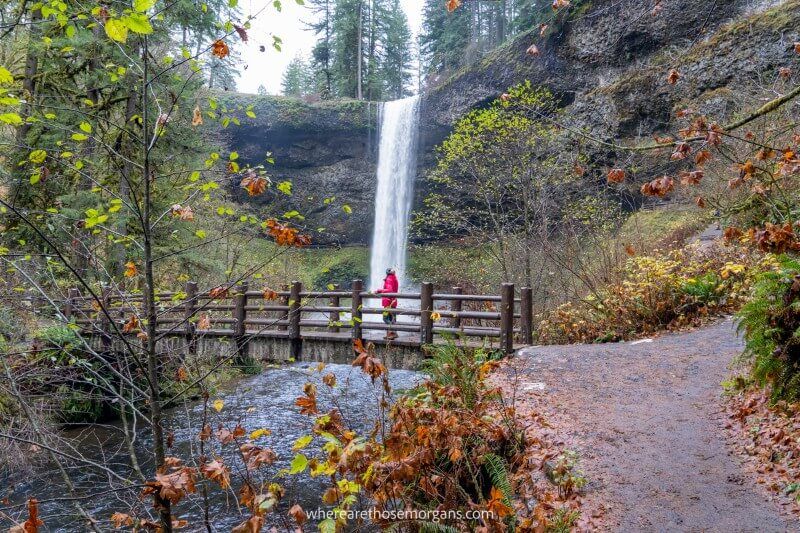
39. Silver Falls Trail Of Ten Falls
- Difficulty: Moderate
- Distance: 7.2 miles roundtrip
- Elevation Gain: 800 feet
- Time: 4-5 hours
- Location: Sublimity, OR
- Season: Year round
The Trail of Ten Falls is a moderately difficult 7.2-mile roundtrip loop hike in Silver Falls State Park, Oregon. It combines a Rim Trail and a Canyon Trail which can be hiked in any direction. The trail passes by 10 waterfalls, some of which you can walk behind.
We hiked the Trail of Ten Falls in October 2021. It’s one of our favorite hidden gem hiking trails in the US. We got a late start and we couldn’t stop taking photos so we ended up finishing the last few waterfalls in near darkness! It’s out of the way, but Silver Falls State Park is definitely worth visiting.
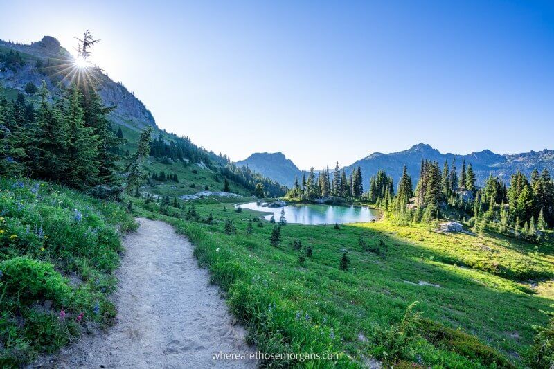
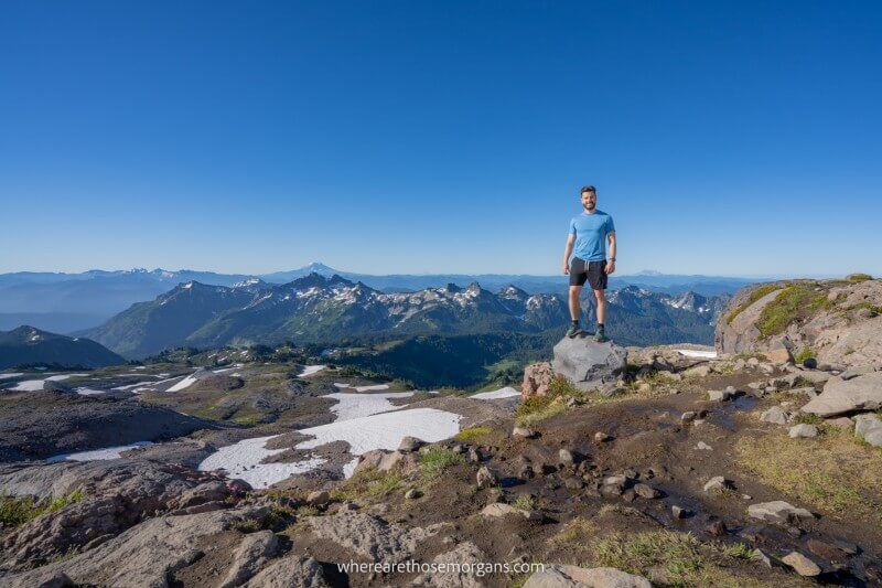
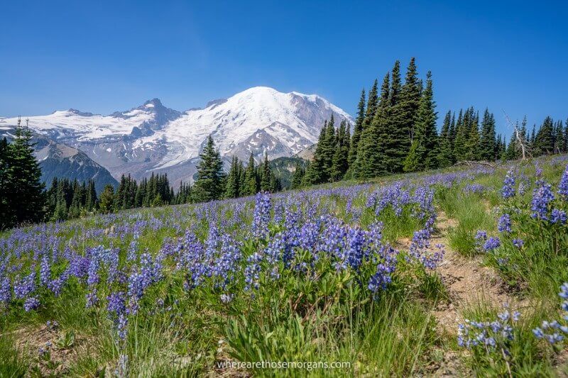
40. Skyline Loop Trail
- Difficulty: Strenuous
- Distance: 5.5 miles roundtrip
- Elevation Gain: 1,700 feet
- Time: 3-5 hours
- Location: Paradise, WA
- Season: July-September
Skyline Loop Trail is a challenging 5.5-mile roundtrip loop hike in Mount Rainier National Park, Washington with a total elevation gain of 1,700 feet. It can be hiked in either direction, but clockwise is the busiest route because has more direct views of the volcano.
We began hiking Skyline Loop Trail counter-clockwise at sunrise in August 2021 to avoid the crowds. It was a truly spectacular hike with waterfalls, meadows, wildflowers and horizon reaching views over mountains and volcanoes. It’s one of the unmissable Mt Rainier hiking trails and we think it has to be on your bucket list.
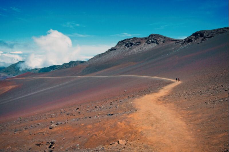
41. Sliding Sands Trail
- Difficulty: Strenuous
- Distance: 11.4 miles roundtrip
- Elevation Gain: 2,500 feet
- Time: 4-8 hours
- Location: Kula, HI
- Season: Year round
Sliding Sands Trail, also known as Keonehe’ehe’e Trail, is a popular hike in Haleakala National Park on Maui, Hawaii. The trail descends from the summit of Haleakala volcano at 10,023 feet to the crater floor. It has an other-worldly landscape with mounds of colorful and shifting sand.
The Sliding Sands Trail is a point to point out and back hike. Beginners can walk just a short way to enjoy the colors, moderate hikers can complete a 5-mile roundtrip route and strong hikers can turn around after seeing Pele’s Paint Pot and Kawilinau volcanic pit.
42. South Kaibab To Bright Angel Trail
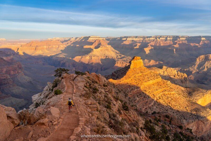
- Difficulty: Strenuous
- Distance: 17.1 miles roundtrip
- Elevation Gain: Loss-4,740 feet | Gain-4,380 feet
- Time: 6-12 hours
- Location: Grand Canyon Village, AZ
- Season: Year round
South Kaibab to Bright Angel Trail, also known as the Rim-to-River Trail, is a serious 17.1-mile day hike at Grand Canyon’s South Rim. It descends 7.3 miles with 4,740 feet elevation loss on South Kaibab Trail to the Colorado River, before climbing 9.8 miles with 4,380 feet elevation gain back to the rim on Bright Angel Trail.
We began our South Kaibab to Bright Angel day hike at sunrise in December 2021. It wasn’t easy but it was definitely one of the most amazing day hikes we’ve ever done. Looking up at the rim from Phantom Ranch on the canyon floor is a sight we won’t forget in a hurry!
43. The Enchantments Trail
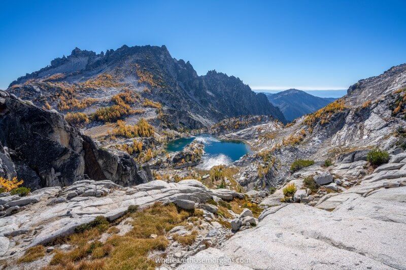
- Difficulty: Strenuous
- Distance: 18.6 miles point to point
- Elevation Gain: Gain-4,549 feet | Loss-6,688 feet
- Time: 9-15 hours
- Location: Leavenworth, WA
- Season: May-October
The Enchantments Trail day hike is a very hard 18.6-mile point to point hike in central Washington. It can be thru-hiked in one long and grueling day or it can be split into a multi-day hike with camping. The trail passes through alpine lakes and meadows, rock scree piles, granite peaks and golden larches in September.
We day hiked The Enchantments in September 2021 and it was one of the toughest but most rewarding trails we’ve ever done. Climbing Aasgard Pass to finally reach the Core Enchantments is hard, but descending 6,688 feet to the end is even harder! This is one of our top US hiking recommendations.
44. The Narrows Trail (Bottom Up)
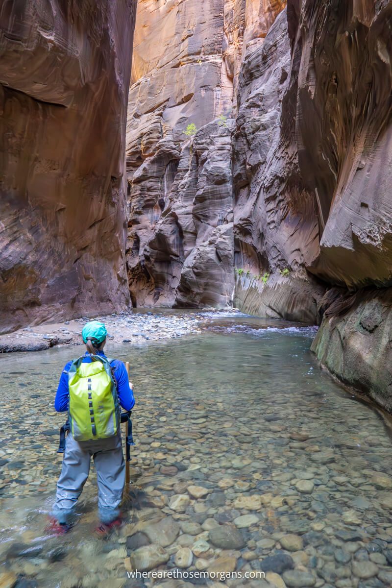
- Difficulty: Strenuous
- Distance: Up to 9.4 miles roundtrip
- Elevation Gain: 100 feet
- Time: 6-10 hours
- Location: Springdale, UT
- Season: Year round
The Narrows Trail is a unique and adventurous river slot canyon hike in Zion National Park, Utah. It can be completed top-down with a permit, or more commonly from the bottom-up without a permit. The bottom up version is a 9.4-mile roundtrip hike from the Temple of Sinawava to Big Springs and back, but many hikers only go 1 or 2 miles into the slot canyon before turning around.
We day hiked The Narrows as far as Big Springs in October 2019 and it was one of the most amazing trails we’ve done to date. Wading through a narrow water-filled canyon for 8 hours with a pole and waterproofs was a totally unique experience for us. This is another essential US hike for your bucket list.
45. The Subway Trail (Bottom Up)
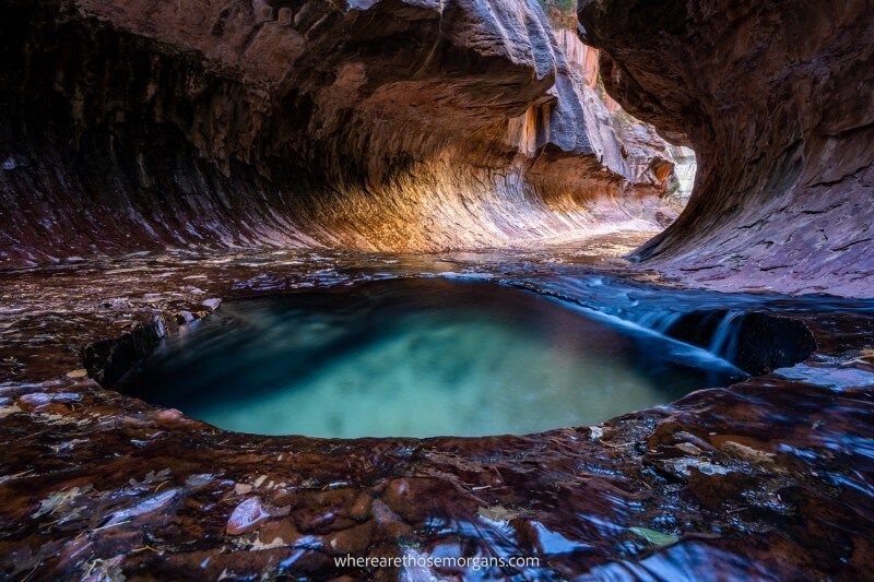
- Difficulty: Strenuous
- Distance: 9 miles roundtrip
- Elevation Gain: 1,300 feet
- Time: 6-8 hours
- Location: Springdale, UT
- Season: Year round
The Subway Trail is a challenging 9-mile roundtrip hike in Zion National Park’s Wilderness Area. It can be walked top-down in two days or bottom-up in one day, but both require a wilderness permit. From Left Fork Trailhead, the bottom-up day hike descends to a creek and heads upstream until reaching The Subway formation.
We hiked The Subway bottom-up in December 2021 with a next-day permit. Forging our own path up the creek was so much fun, with steep banks and several river crossings to navigate. And at the end, The Subway was one of the most unique photo spots we’ve seen in any US national park.
46. The Wave Trail
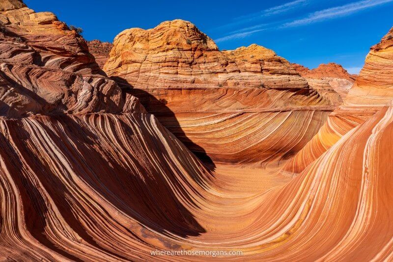
- Difficulty: Moderate
- Distance: 6+ miles roundtrip
- Elevation Gain: 450+ feet
- Time: 3-4 hours
- Location: Kanab, UT
- Season: Year round
The Wave Trail is a moderately difficult 6-mile roundtrip hike on red rocks and sand with 450 feet elevation gain in Vermilion Cliffs National Monument on the Utah and Arizona border. That doesn’t sound like anything special, but trust us, the end of the trail at The Wave is like nowhere you’ve ever seen before.
We won a Wave lottery permit (it’s the hardest hiking permit to win in America!) and hiked the fun trail to The Wave in December 2021. It’s the most uniquely photogenic landscape we’ve ever seen and we’d go back in a heartbeat. In fact, we’d say it’s easily among the most beautiful photo spots in the US.
47. Waimoku Falls Trail
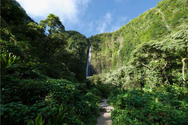
- Difficulty: Moderate
- Distance: 4 miles roundtrip
- Elevation Gain: 900 feet
- Time: 2-3 hours
- Location: Hana, HI
- Season: Year round
The Waimoku Falls Trail is a moderately difficult 4-mile roundtrip hike in Haleakala National Park on Maui, Hawaii. It begins at Pipiwai Trailhead on the famous Road to Hana and leads through dense forest before ending at the 400-foot tall Waimoku Falls.
Stop at the Falls at Makahiku and a gigantic Banyan Tree to break up the gradual 650 feet of elevation gain. If you’re visiting Maui anytime soon, this trail should be included in your itinerary.
48. Watkins Glen Gorge Trail
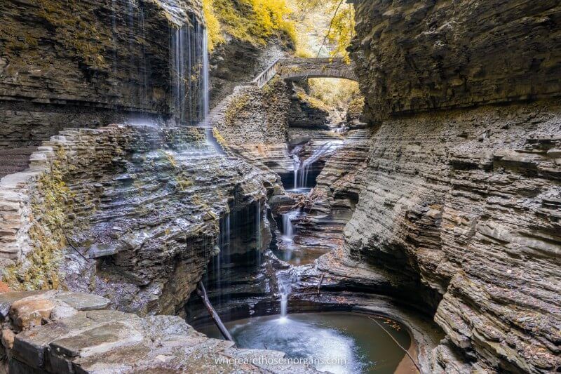
- Difficulty: Moderate
- Distance: 3 miles roundtrip
- Elevation Gain: 300 feet
- Time: 2-3 hours
- Location: Watkins Glen, NY
- Season: May-October
The Watkins Glen Gorge Trail is a moderately difficult 3-mile roundtrip loop hike running through Watkins Glen State Park, New York. The man-made trail with 832 stone steps leads through the base of a 400-foot deep gorge following Glen Creek. It passes by a total of 19 waterfalls.
We’ve hiked Watkins Glen Gorge Trail at least 10 times. It’s like being transported to a fantasy world with tunnels, rock formations and waterfalls carved into a narrow gorge. Near the end, Rainbow Falls is one of the most picture-perfect scenes imaginable.
49. Wheeler Peak Trail
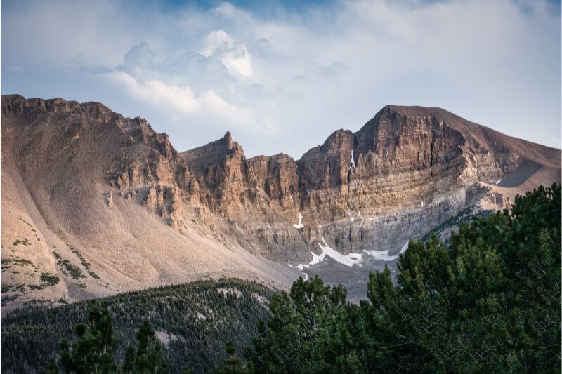
- Difficulty: Strenuous
- Distance: 8.2 miles roundtrip
- Elevation Gain: 2,961 feet
- Time: 5-8 hours
- Location: Taos Ski Valley, NM
- Season: June-October
Wheeler Peak is the highest point in New Mexico at 13,161 feet above sea level. There are multiple trails leading to Wheeler Peak, but the best route is the challenging 8.2-mile roundtrip hike with almost 3,000 feet elevation gain on Williams Lake Trail.
The final third of the hike to Wheeler Peak after Williams Lake is mostly scree field. But summit views over Taos Valley, Wheeler Peak wilderness and the Sangro de Cristo mountains in Colorado are well worth the climb.
50. Wonderland Trail
- Difficulty: Strenuous
- Distance: 93 miles roundtrip
- Elevation Gain: 22,000 feet
- Time: 6-12 days
- Location: Paradise, WA
- Season: June-October
The Wonderland Trail is a challenging 93-mile loop hike circling Mount Rainier in Washington. It’s a grueling multi-day hike with around 22,000 feet total elevation gain. The hike passes through forests, valleys, alpine lakes and mountains as it takes in the best scenery around Mount Rainier National Park.
We’ve hiked several sections of the stunning Wonderland Trail across multiple visit to Mt Rainier. Hiking the whole loop around the volcano is a fantastic way to cut out driving time between the 5 regions and inevitable parking issues at trailheads. Grab your hiking buddies and head for Mt Rainier this year!
Our Top 10 USA Hikes
It’s almost impossible to confidently say which US hikes are the best because it’s just too subjective. Our favorite hike might be your 15th favorite or 49th favorite. But for arguments sake, here’s our personal top 10 favorite USA hiking trails ranked in order.
- The Narrows (UT)
- South Kaibab to Bright Angel (AZ)
- The Enchantments (WA)
- The Wave (AZ)
- Skyline Loop (WA)
- Old Rag (VA)
- Maple Pass Loop (WA)
- Mt Monadnock (NH)
- Angels Landing (UT)
- Watkins Glen Gorge (NY)
Don’t agree? Let us know your favorite trail in the comments below!
We hope our US hiking trails guide helps with filling up your bucket list!
Please let us know if you have any questions in the comments below.
Happy Hiking,
Mark and Kristen
Enjoy this guide? Pin it for later!


All Rights Reserved © Where Are Those Morgans, LLC. Republishing this article and/or any of its contents (text, photography, maps, graphics, etc.) in whole or in part is strictly prohibited.

Mark and Kristen spent 6 years traveling the world, visiting over 40 countries across 4 continents and more than 30 US states. They created Where Are Those Morgans in 2018 to help others plan the best possible vacations by writing authentic travel and hiking guides based on their real experiences.
Since the arrival of baby Maya in late 2024, Mark and Kristen’s extensive travels have slowed down but they still take plenty of trips. Where Are Those Morgans now helps millions of travelers each year to visit new places and hike new trails through information-packed blog posts and expert travel guidebooks. Read more about Mark and Kristen.