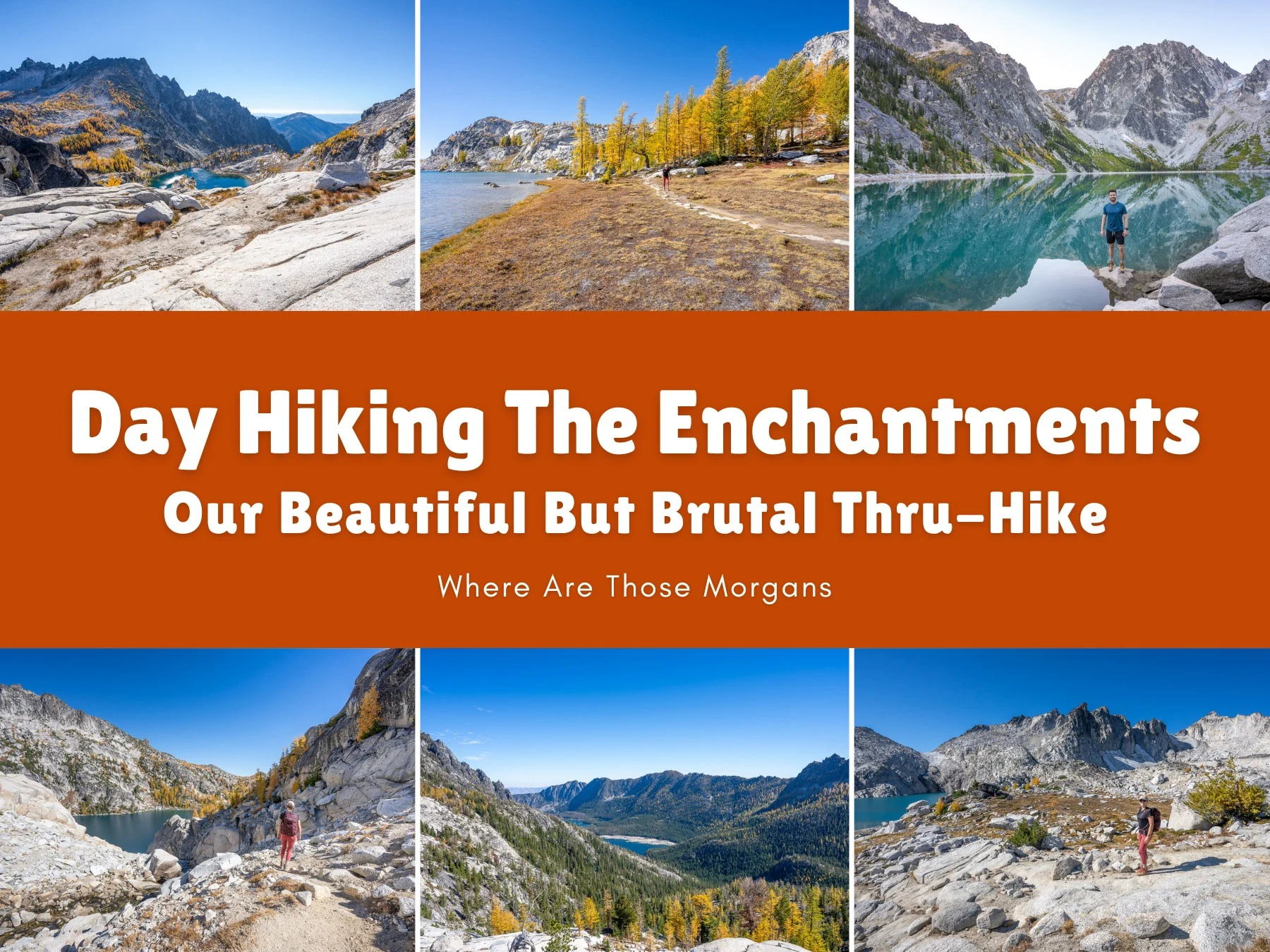
When we moved to Seattle for the middle 6 months of 2021, we had a massive bucket list of hikes we wanted to complete in Washington’s three national parks and everywhere in-between. Day hiking The Enchantments was near the top of our list, but we waited patiently until late September because we wanted to do it when the golden larches were in peak – and we’re so glad we held off, the colors were magnificent.
Where do we even begin with describing our Enchantments thru-hike? In four words: beautiful, brutal, rewarding, exhausting. All in equal parts. It was a monstrous 18.6-mile hike with a ridiculous amount of elevation gain and loss that challenged us both physically and mentally. We had to be organized with transport, start early and finish late, pack the right gear, manage our moving vs resting time effectively, and avoid injuries. It’s up there with the hardest day hikes we’ve ever done, but it was also one of the most memorable.

Hi, we’re Mark and Kristen Morgan. We left our scientific careers in 2018 to become travel writers and photographers, and since then our expert guides have helped millions of travel planners take better trips. Read more about us.
Why trust us with your Enchantments thru-hike? We travel and hike for a living, we actually lived in Washington, and we day hiked The Enchantments on September 25th, 2021. As always, every photo in this guide is ours.
In a nutshell: We drove to Snow Lakes trailhead in the dark, dropped the car and excitedly hopped on a shuttle bus we’d pre-booked to Stuart/Colchuck Lake trailhead, gradually climbed to Colchuck Lake in the dark with headlamps, sharply climbed the outrageously steep Aasgard Pass, had our minds blown by the Core Enchantments, descended steeply to Snow Lakes, and fought hard through a grueling descent to Snow Lakes Trailhead. By the end our bodies were in pieces, our feet were shredded, and we were running on fumes.
If you asked us right after the hike whether we’d do it again, we’d have said never in a million years. But they say time is a healer, and our mental scars are all but gone. Ask us now? We’d love to hike it again. In this guide we show you our hiking stats, explain trailhead logistics, walk you step by step through our incredible Enchantments day hike so you can see what you’re up against, and share the most important things we learned that will help you have a better experience. Let’s dive in!
Note: Our content is reader supported and contains affiliate links. If you make a purchase through one of these links, we may earn a small commission at no extra cost to you and it helps us keep this site running.
Need a hand planning your trip to Washington? We help independent travelers plan better, stress-free trips. Join a video call with Mark and we’ll build the perfect itinerary for your style, budget and priorities. See our travel planning help.
Trail Map & Hiking Statistics
Let’s start by looking at our trail map, specific hiking stats from our Gaia GPS app, and a summary of the distances and elevation changes for each different section of the hike.

Take note of the steps in our Enchantments trail map. The earlier part of the hike felt busy with things like making sure we turned left at the trail split for Colchuck Lake instead of right to Stuart Lake, and trying not to think too much about the mammoth climb up Aasgard Pass. But after the Core Enchantments, there were fewer landmarks or directional changes to consider. It was a case of getting our heads down and just grinding it out.

This is just a top level summary of our distance, elevation gain and loss, and total time from Stuart/Colchuck Lake trailhead to Snow Lakes trailhead. So let’s break it down further – here are the in-depth statistics we took from our Gaia GPS app after day hiking The Enchantments:
- Distance: 18.61 miles
- Ascent: 4,551 ft
- Descent: 6,690 ft
- Average Speed: 1.4 mph
- Moving Speed: 1.6 mph
- Max Speed: 3.9 mph
- Moving Time: 11h 15m
- Stopped Time: 1h 41m
- Total Time: 12h 56m
We consider ourselves strong hikers with lots of experience. By no means the strongest, but well above average. Our moving time was 11 hours 15 minutes, but we factored in plenty of stops for food, photos and honestly to take it all in. So our total time was 12 hours 56 minutes – that’s a long old day.
We imagine trail runners might do it in 6 or 7 hours, whereas slower hikers might take 15 or 16 hours to finish. But it’s not all about speed, it’s also about being safe and enjoying the scenery.
Oh, and if you think our moving speed of 1.6 mph is slow, just wait until you get on the trail. It isn’t just the long distance that makes this a hard hike, it’s the nature of the steep elevation gains and losses throughout. There are surprisingly few periods in which you’re walking on flat and level ground, so it’s hard to get up any real speed.
Finally, here’s our rounded summary of distances and elevation change for each segment:
| Segment | Distance | Elevation Change |
|---|---|---|
| Stuart/Colchuck TH → Colchuck Lake | 4 miles | +2,300 ft gain |
| Colchuck Lake → Top of Aasgard Pass | 1.5 miles | +2,000 ft gain |
| Top of Aasgard Pass → Lake Viviane | 3 miles | -700 ft net (+250 ft gain / -1,100 ft loss) |
| Lake Viviane → Snow Lakes | 3 miles | -1,400 ft loss |
| Snow Lakes → Snow Lakes TH | 7 miles | -4,200 ft loss |
| Total | 18.5 miles | + 4,550 ft gain / -6,700 ft loss |
There were no distance markers or anything at all that gave us an indication of how far we’d hiked, or how far we had left to go. So following our live progress on our offline Gaia GPS map helped to keep us sane, especially towards the end.
The Enchantments Trailhead Logistics
Normally we wouldn’t make such a song and dance about getting to a trailhead. But when we began researching how to thru hike The Enchantments in one day from Stuart/Colchuck Lake Trailhead to Snow Lakes Trailhead (by far the most popular route), we noticed that the start and end of the hike were 8 miles apart by car, and our first thought was “well, how on earth are we going to do this then?”
There’s no way we’d be able to hike another 8 miles at the end back to our car. If we had a second car we might have dropped one at Snow Lakes Trailhead early morning, then driven to Stuart/Colchuck Lake Trailhead after the hike to pick it up, but that road was slow going and took close to 30 minutes so that would add on another hour at the end of the day. And we had no other family members with us who could drop us off and pick us up.

Our solution? Thankfully, there was a third option for people in our situation. We pre-booked a shuttle bus online with a company called loop connector shuttle that ferried us from Snow Lakes Trailhead to Stuart/Colchuck Lake Trailhead. It was very easy to book and we received an email with a precise meeting location and time. Spaces were limited to 12 hikers on each of the 3 runs the shuttle bus makes each morning at 5:00 AM, 6:00 AM, and 7:00 AM. We booked ours a month or so in advance and it cost us $24 per person (it’s now $27). Without it, we’re not sure if we’d have been able to do the hike.
That meant all we had to do was park our car at Snow Lakes Trailhead first thing in the morning. There was a small parking area along Icicle Creek Road, and even though we arrived at 4:45 AM, the lot looked pretty full so we didn’t risk losing time trying to find a space, and instead we parked in an open spot on the roadside around 100 ft from the off-road parking area, which also served as the meeting point for our 5:00 AM shuttle.
Kristen’s top planning tip: Parking passes must be displayed at both trailheads. We parked at Snow Lakes Trailhead and used our America the Beautiful Pass, but we also could have used a Northwest Forest Pass. Without either pass, we’d have bought a $5 day pass on site in either parking area.
Our Trail Walkthrough
Here’s a step-by-step walkthrough of our long day hike with photos we took along the route:
Making Our Way To Stuart/Colchuck Lake Trailhead
When our alarm went off at the awful time of 3:45 AM, we groaned, groggily slipped into our hiking gear, stuffed ourselves full of high-energy breakfast foods, and sipped on very large cups of B&B coffee to-go for our 10-minute drive to Snow Lakes Trailhead. We arrived by 4:45 AM, found a parking spot on the roadside, met our shuttle driver, and settled in for a 30-minute drive to Stuart/Colchuck Lake Trailhead.

After chatting to other hikers about how grateful we all were for the easy logistics, we quickly used the vault toilet, before signing the register. We had to fill in a form, rip off the bottom, post it in the box, and tie the tag to our backpack. Finally, we were ready to start our one day hike through The Enchantments, so we strapped on our headlamps and set off at bang on 5:30 AM.
Mark’s lodging tip: We stayed at Granite Hills Inn which was half way between Leavenworth and Snow Lakes Trailhead. It was a lovely stay, but unfortunately the owners sold the inn in 2024. But we also stayed at Enzian Inn on a different trip to Leavenworth and really liked it, so it’s our top hotel recommendation for friends, family and clients.
Beginning Our Hike To Colchuck Lake
All that stood between us and the first major landmark called Colchuck Lake was 4 miles and 2,300 ft elevation gain that we’d have to do in total darkness. We’d been mentally preparing ourselves to climb Aasgard Pass, but we didn’t give much thought to what came before the mighty pass. And honestly, that was a mistake. Climbing 2,300 ft was no joke.

The first mile and a half began softly on a bouncy dirt packed forest path, but after crossing a wooden bridge, it soon turned into a long and constant climb. Honestly, at this point we were running on adrenaline and caffeine. It was also a busy weekend morning in peak golden larch season, so there were a lot of hikers climbing in a hurry to reach Colchuck Lake. From above all you’d see is a long trail of headlamps scurrying up a mountainside.
Turning Left At The Trail Fork
After some pretty steep trail sections, we eventually reached a flatter area with a four way X-junction. To the right was a vault toilet, straight ahead was the path to Stuart Lake, and to the left was the route we followed heading for Colchuck Lake – which almost immediately opened into an enormous boulder field.

The morning was beginning to light up so we were finally able to turn our headlamps off, and that made a big difference for our perception and spacial awareness. We crossed a wooden bridge and navigated the boulder field, then hit switchbacks leading through more forested sections for the last mile or so before reaching the lake. Views of rugged mountaintops glowing at sunrise began to open up, and the morning’s hard work already felt worthwhile.
Taking A Quick Break At Colchuck Lake
With mixed emotions of relief and anxiety, we instantly knew when the first major elevation gain segment to the lake was over because the trail flattened, turned slightly to the right, and we could see water through trees. Why the anxiety? Because we knew Aasgard Pass was next. But after following a maze of dirt trails, we took a short spur leading down to huge smooth boulders on the edge of Colchuck Lake, and wow, the scene ahead was simply spectacular.

We stopped on the edge of Colchuck Lake for around 15 minutes, snapped some photos (we got our camera out for the only time other than the Core Enchantments), ate energy snacks, and took a quick breather. The whole area was still blanketed in shadow so we got a bit chilly, but just looking beyond the lake at Aasgard Pass filled us with more adrenaline and warmed us right back up!
Arriving At The Bottom Of Aasgard Pass
By this point we’d climbed 2,300 ft over 4 miles, next we had to circle around Colchuck Lake to the bottom of Aasgard Pass, and then climb 2,000 ft in just three-quarters of a mile. Oh boy! On the far side of the lake, we navigated more boulders and large stones, followed cairns, and even walked on a small beach. But in truth, we were using this flat and easy section to mentally prepare for the climb, knowing it was going to be rough but feeling strangely excited at the same time.

As we arrived at the bottom of the near-vertical pass, we sort of plotted a rough route looking at landmarks and where other hikers were going. We chose a very obvious grove of larch trees around half way up the pass to the left of center as a marker, and our goal was to climb to the left side of the grove. Mark made one last nervous joke, and it was the last time either of us smiled for over an hour!
Climbing The Brutal Aasgard Pass
There wasn’t one path leading up Aasgard Pass that everyone followed. It was more like a maze of very steep gravel trails covered by thousands of loose rocks. The going was slow, steep, and slippery underfoot. We took our time, carefully considered foot placements and and next steps on the route up, and we also took plenty of short breaks to recover. The intense incline was a killer and everything was burning: calves, hamstrings, quads, glutes, lower back, you name it.

Below us, Colchuck Lake was quickly getting smaller and the view behind it was getting more expansive by the minute. We passed the larch grove on its left side, kept mentally focussed, and helped support other hikers on the climb. Next, we crossed a creek of rushing water, and then we had to use our hands to help us get through a particularly rocky section. Finally, we navigated more enormous boulders and pushed hard for the top.
Summiting Aasgard Pass
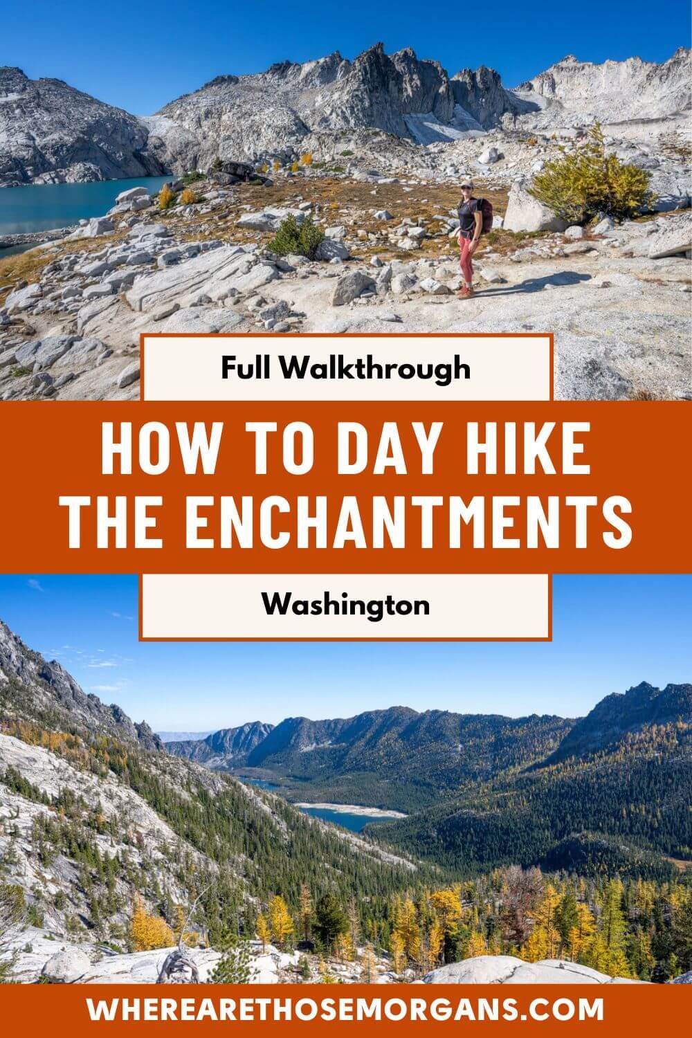
Summiting Aasgard Pass at 7,800 ft elevation was a wonderful feeling, bordering on emotional. We’d conquered a ridiculously steep climb, the sun was finally shining on our faces, the views were immense, and we knew that was all the elevation gain over for The Enchantments. But our bubble burst very quickly as it dawned on us that we’d only done 5.5 miles of the 18.6-mile hike, and we were already pretty wrecked.

We were sure the next few hours hiking through the Core Enchantments would be amazing, but straight after the colossal climb was over and our minds cleared, we suddenly became acutely aware of other important considerations – like food, water, energy, time, and daylight hours. Sweeping those concerns aside, we got stuck into the core – this is what all the hard work was for, after all.
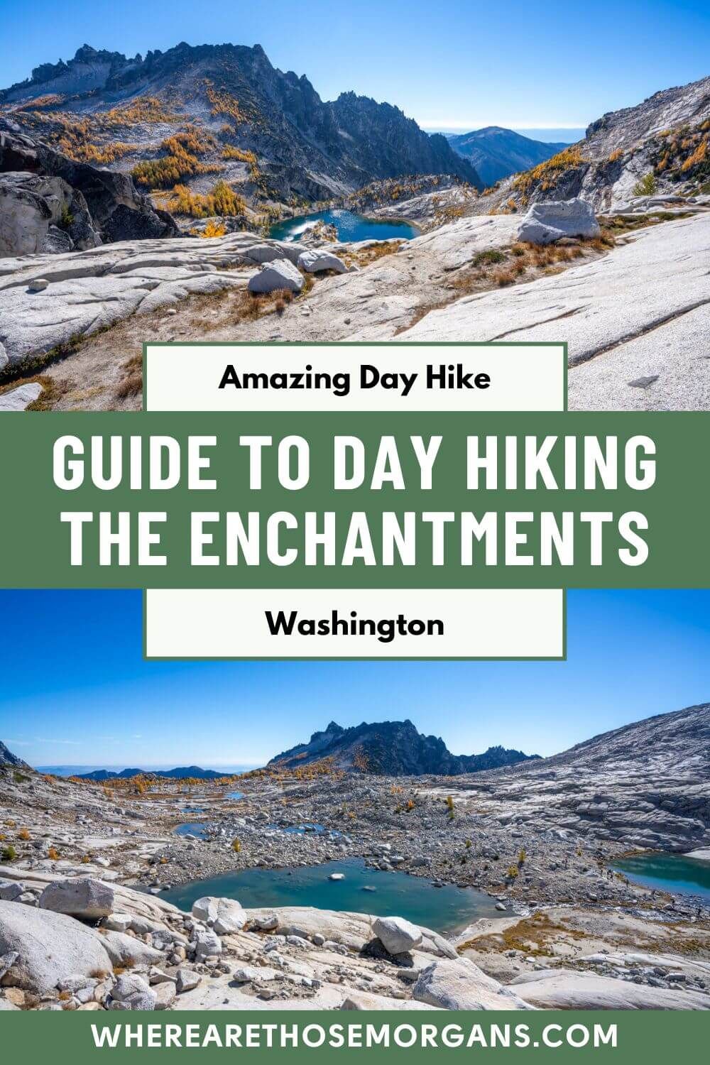
Enjoying The Picturesque Upper Enchantments
Immediately after summiting Aasgard Pass, we had a little more gradual climbing to do but it only lasted a few minutes. Our first views over the Core Enchantments were of Tranquil Lake and Isolation Lake, and we were completely blown away. We stopped at a viewpoint for a food break and could barely believe the scene: a deep blue sky above a sun-beaten rocky landscape dotted with azure lakes and golden larches.

We ate, applied a ton of sunscreen, and put on hats and sunglasses for protection against the sun. The trail through the Upper Enchantments wasn’t a set path, so we walked freely over gray rocks in the same general direction as other hikers, loosely making sure we could see cairns and large poles that were in place for general directions. Honestly, despite being stunning, we actually thought the Upper Enchantments was the least attractive part of the core area.
Being Blown Away By The Middle Enchantments
The Middle Enchantments area was our favorite part of the whole hike. After reaching a plateau-like shelf, we dropped into an encampment, and on the other side we were left genuinely stunned by a beautiful view of Crystal Lake and Ingalls Creek Valley. All of a sudden, the scenery transformed from amazing to truly staggering, so we took a moment to snap some photos before swiftly moving on.

Picturesque lakes started coming at us thick and fast now. First, we arrived high above the glass-like Inspiration Lake, surrounded 270-degrees by tall granite cliffs and a patch of larch trees hugging its right flank. We dropped down a steep boulder path and walked along the lakeshore, refilled our water bottles (using a LifeStraw) and took a 5 minute snack break on the shoreline.
A few minutes later we began a gradual descent down to Perfection Lake. This is where we saw the highest concentration of golden larches surrounding a lake and sprawling across flat grassy meadows. We walked to the lake’s northern tip, following the trail as it twisted through serene forest and larch groves. Eventually, we reached Sprite Lake and took a longer lunch break with awesome views looking back where we’d just come from.
Soaking Up The End Of The Core In The Lower Enchantments
After our lunch stop, we took a longer and more open descent dropping down into the Lower Enchantments. This was honestly the very first time that we’d really had a chance to open up a good pace within the Core Enchantments. But not long after we reached the oddly shaped Leprechaun Lake nestled at the base of McClellan Peak, and to pass around, we had to traverse narrow ledges and large boulders with steep drops into the lake.

The scrambling was fun but slow going, and afterwards we climbed a steep rocky patch into a surprisingly open area, keeping Lake Viviane to our left. We actually thought Lake Viviane was the most postcard-perfect lake we’d seen since leaving Colchuck Lake a few hours ago, so it was a nice way to go out of the core.
But right near the end of the core we still had one final sketchy trail section to deal with as we passed Lake Viviane. Part of the path required a specific sequence of footwork and hand placements in order to continue, and there were anxious hikers bottlenecking in both directions, which didn’t help the already-nervous people slowing it down.
Descending Steeply To Snow Lakes
And that was it, just 3 miles after summiting Aasgard Pass and the Core Enchantments were over. Once we’d navigated the sketchy trail section, we reached a ledge with far reaching views stretching for miles into a valley below with two bodies of water. They were the Snow Lakes, and this was where the real mental and physical challenge began on our Enchantments day hike. We’d covered 8.5 miles, so we had 10 miles to go – and the best part was over.

Because we’d been so obsessed with worrying about climbing Aasgard Pass, we really had no idea what to expect from the descent. And that was another mistake we made. The descent genuinely turned out to be so much harder than we ever would have imagined, and it began immediately. Straight off the bat, the trail turned steep with open and severely angled rock faces, no clear path or foot placements, scrambling sections, and shuffle-down-on-your-butt sections.
Our ankles, knees and hips started to groan, our muscles burned, and our joints started to ache. The problem for that 3-mile descent wasn’t even the 1,400 ft elevation loss, it was never being able to get any speed up because the trail was too steep and uneven. That said, the scenery was still beautiful and after the exposed Core Enchantments, we finally had a welcome respite from the sun and elements.
Grinding Out The Long, Slow & Grueling Final Stretch
Reaching Snow Lakes felt like a real milestone, so we took a well deserved break, filled up with water, and ate a ton of snacks. It can’t be far now we’ve cracked out the worst of the downhill, right? Wrong. We still had 7 miles with more than 4,000 ft elevation loss to come. And that was our second major “oh, boy” moment.

We hugged the southern edge of the first lake, before following a path northeast which dissected the two lakes. This forest path was a dream come true – soft and bouncy, and it felt like walking on clouds. Picking up a normal walking pace had never felt better. But after crossing a long and narrow wooden bridge, we entered a forest for a short time before it turned to rocks and gravel, and this is when every step began to hurt.
Eventually, we reached the left flank of Nada Lake before the trail disappeared into forest. We continued to lose elevation, turn corners, snake through yet more forest, and cross creeks for what felt like an eternity. When we look back on our hike, it’s this final 5 or so miles that bring back the worst memories. Hikers all around us were hurting, hobbling, and delirious. And we’re not exaggerating.
Ending At Snow Lakes Trailhead
The penultimate set of switchbacks were on a narrow section of trail dropping through dense forest with vegetation bursting out in all directions. Another short set of switchbacks, followed by another. By now we were utterly spent. A combination of grit, determination, muscle memory, and knowing we had no other options were all that kept our legs moving. But the final set of switchbacks were a killer.

Sheer delight at finally being able to see the distant parking lot helped our mental states (a hiker behind us actually started crying happy tears), but we weren’t far off 13 hours total time and those last 20 switchbacks felt like they were never going to end. Finally, we dragged ourselves over a wooden bridge crossing Icicle Creek, and a short hill brought us into Snow Lakes Trailhead parking lot. Pure relief, crushing fatigue, and a massive sense of achievement all washed over us in an instant. We’d successfully hiked The Enchantments in one day.
What To Pack
We’d say packing is probably the most underrated part of planning this day hike. A lot depends on conditions, so check Leavenworth’s weather forecast. We were lucky with beautiful sun and warmth at the end of September, so it made packing a bit easier, but we still made a few mistakes and we’d do it differently next time.
First, remember that every single thing packed means more weight, and all the climbing is at the beginning of the hike. For us, the key was to pack enough food to sustain us but without making our day packs too heavy. We started with filled water bottles, but the big difference-maker for us was carrying a water filter so we didn’t have to carry all of our water for the whole hike. We’re not sure that would even be doable to be honest.
Here’s what we packed:
- Food: Sandwiches, energy/granola bars, trail mix, muffins, fruit gummies, chocolate bars, energy gels.
- Water: 2.5L reservoir for Kristen’s Osprey Skimmer 28L backpack, 1 liter water bottle in Mark’s pack, plus a LifeStraw to filter water.
- Media: Camera and lens, smartphone.
- First Aid: Full emergency first aid kit with foil blanket, sunscreen, band aids, and aspirin.
- Headlamp: Must-have for the morning, but may also be needed at the end.
- Clothes: Thin and lightweight fleece layers, gloves, down jackets, spare socks, and baseball caps.
Mark started in shorts with a moisture-wicking shirt, very light pullover, and down jacket. The down jacket lasted 2 minutes, and the pullover came off before climbing Aasgard Pass and stayed off until near the end on the final switchbacks when it got cooler. Kristen started in sports leggings with a moisture-wicking shirt, fleece vest, and down jacket. Again, the down jacket was packed away very quickly and the fleece didn’t last long either. But it was important we had those warmer layers just in case of emergency.
We considered taking two cameras, two lenses and a gimbal so we could photograph and video the hike. But after careful consideration we decided one camera and one lens was enough weight to carry. And it was the best decision we made. We were tired enough by the end and all that additional weight might have given us a real problem.

Our Footwear Mistake
On any old day hike, a pair of standard running shoes often does the trick. But The Enchantments is not just any old day hike. It’s a punishing 18.6-mile hike with 4,550 ft elevation gain and 6,700 ft elevation loss that can take anywhere between 10-15 hours to walk. So what’s the single most important thing to consider? Footwear.
There were very few sections of this hike when we found ourselves walking on flat ground. It was almost exclusively gaining or losing elevation, and constant stepping up or down onto jagged rocks. The worst part for us was walking on steeply angled rock faces, which would wreck our ankles. Trust us when we tell you, looking after your feet is paramount, and if you get it wrong you’ll be in big trouble.
We had several footwear options, and after a lot of discussion, we agreed to go with our more robust shoes that would stand up against the rugged terrain – Kristen wore her Columbia hiking boots and Mark wore Adidas Terrex Free Hikers. Now, it wasn’t a terrible decision by any means, but on the long descent after Snow Lakes, we both wished we’d worn something a little less bulky. Every up and down movement was killing us by the end with such clunky footwear, and we did have blisters.
Looking back, we wished we’d worn our trail runners. Still sturdy and robust, but far more flexible and pliable for those endless angled stones and steps. So next time we’d wear trail runners. But we’d make sure they were well worn in, and we’d also make sure we had a winning sock-shoe combo that we could rely on. We absolutely would not wear new shoes or even shoes that we felt unsure about. Poor shoe choice has the potential to be a real issue.
Important Things We Learned
Parking pass and permit: We had to display a parking pass (America the Beautiful, Northwest, or $5 day-use fee) in our car AND fill out a free self-issued day-use permit at the trailhead.
Point to point logistics: We were relieved that we planned far enough in advance and managed to secure a place on the earliest shuttle bus through Loop Connector Shuttle. We’d book with them again, but Leavenworth Shuttle also run the same service if it was full. A lot of people parked a second car at Stuart/Colchuck Lake with the intention to pick it up at the end, but using the shuttle was so much more convenient.
Starting early: Getting that earlier shuttle meant we could start the hike at 5:30 AM, and that gave us a decent amount of fudge room. Any later and we’d have been nervous about finishing it in daylight. To be honest, if there was a 4:00 AM shuttle we’d book that and start the hike even earlier.
Exposed sections: Both the Core Enchantments and the final 5 miles of the hike from Snow Lakes to Snow Lakes Trailhead were mostly exposed with little shade. Now, we day hiked The Enchantments at the end of September so excessive heat wasn’t an issue for us. But if we planned the hike in summer, we’d check Leavenworth’s weather forecast and make sure it wasn’t going to be too hot. The final stretch is brutal enough without factoring in heat exhaustion or dehydration.
Aasgard Pass: Almost every hiker ahead of us aimed climbers-left of the larch grove half way up the pass. We only saw a few people go the other way and they got stuck, had to turn around, and wasted energy. Stay left. We’d also give serious thought to any hidden traps under the snow if we hiked earlier or later in the season.
Offline maps: Being able to track our live location on our downloaded, offline Gaia GPS map was a mental lifesaver. Especially as we got closer to the end, we kept our spirits up by counting down the miles. AllTrails is the other major option.
Trail split: The only real trail fork to be aware of is the left turn to Colchuck Lake at the junction with Stuart Lake (which is straight ahead at the sign). It’s very obvious in daylight, but arriving at that point in the dark could lead to missing the sign altogether.
Water: Keeping weight down is vital on a hike this hard, so having our LifeStraw was a game-changer. We filled our reservoir and bottle several times through the Core Enchantments area, but water availability dropped considerably from Snow Lakes down to the trailhead.

Food: We honestly thought we’d packed too much food, but we’d burned through it all by Snow Lakes and we finished the hike hungry. Thirteen hours of constant calorie burning is no joke, so next time we’d pack even more food.
Poles: We don’t use trekking poles, so this was never a consideration for us. But we saw a clear split between people with them and without them during our hike, so this one is down to personal preference. We wouldn’t want to persuade or dissuade you.
The core: It was tough because of how beautiful it was, but we rightfully decided not to spend too much time soaking up the Core Enchantments. We took quick breaks, sometimes even slowly walking with food and drinks, to keep on top of our time management.
Lake Viviane: After passing by Lake Viviane and arriving at the ledge with views over Snow Lakes, we had to really prepare ourselves psychologically that the best part of the hike was over and from this point on it was a slog to finish.
The descent: We’ve completed some seriously tough one-day and multi-day hikes around the world, and honestly the descent on The Enchantments is up there with the hardest things we’ve done. The climb is challenging but it’s early in the day, whereas the long and slow descent is at the end of the day when energy levels are non-existent. Do not underestimate the descent.
Going the other way: We never even considered going east to west from Snow Lakes Trailhead to Stuart/Colchuck Lake Trailhead because something like 90-95% of all hikers follow the “gold standard” route going up Aasgard Pass and down to Snow Lakes. We would still go the usual west to east route next time.
Dogs: Dogs are not permitted anywhere within the Enchantments permit area. We never saw any dogs, but we have read hiker comments on AllTrails suggesting rangers issues tickets to dog owners.
When to hike: Our end of September hike with peak golden larches was immense, but we were also very lucky with clear sunny weather. It could have been very different that late in the season. We wouldn’t risk May or June because of snow. July could still have snow, but it also has longer daylight hours and wildflowers. That said, the bugs are bad in July and August, but August has other issues like wildfire smoke and overcrowding issues. Early September could be the sweet spot, but if conditions were clear, we’d hold out for the end of September and golden larches again next time.
Was Our Enchantments Day Hike Worth The Massive Effort?
There isn’t a single shred of doubt in our minds that day hiking The Enchantments was a truly incredible experience. It’s right up there with our favorite hiking memories of all time, and we do this for a living. But it’s important to mention that we were organized with trailhead logistics, we had golden larches, the trail wasn’t overrun by other hikers, and the weather conditions were near-perfect.
If any of those things were different, we might not have enjoyed it quite as much. And the constant pounding on jagged, steep, angled, and uneven terrain for hours and hours definitely took its toll on our joints, bones and muscles. In truth, we wouldn’t have been disappointed if the hike finished after we’d gotten through the Core Enchantments. The ten miles after that point were brutal.
Factoring in the very early start, paying for the shuttle, the scenery, and how we felt at the end – we’d say it was 100% worth the effort. Feeling wrecked, bruised, and unable to walk for a few days after was a small price to pay for the staggering landscapes and sense of achievement. We’d love to do it again, but we’d train hard and be more prepared for the punishing descent.

Next Steps
We hope our Enchantments day hiking guide helps with planning your trip to Washington’s Cascade Mountains.
Don’t forget you can book a travel planning video call with us if you’d like our expert help organizing your trip. We can answer any questions you have or walk through a personalized itinerary to make the most of your time.
Still researching for your trip?
- Here are the top hikes in Mt Rainier
- Here’s how to hike Mt Pilchuck
- This is our Lake 22 hiking guide
- Here’s how to hike Wallace Falls
- Here’s our Lake Serene hiking guide
- This is how to visit Snoqualmie Falls
Finally, if you’ll be visiting more places on the same trip, we recommend reading our Washington State travel guide for more helpful tips and advice.
Happy Travels,
Mark and Kristen
Enjoy this guide? Pin it for later!
All Rights Reserved © Where Are Those Morgans, LLC. Republishing this article and/or any of its contents (text, photography, maps, graphics, etc.) in whole or in part is strictly prohibited.

Mark and Kristen spent 6 years traveling the world, visiting over 40 countries across 4 continents and more than 30 US states. They created Where Are Those Morgans in 2018 to help others plan the best possible vacations by writing authentic travel and hiking guides based on their real experiences.
Since the arrival of baby Maya in late 2024, Mark and Kristen’s extensive travels have slowed down but they still take plenty of trips. Where Are Those Morgans now helps millions of travelers each year to visit new places and hike new trails through information-packed blog posts and expert travel guidebooks. Read more about Mark and Kristen.
Thank you so much it is a wonderful information to my…..super helpful.🙏
You’re very welcome, Maria – we hope you have a fantastic hike!