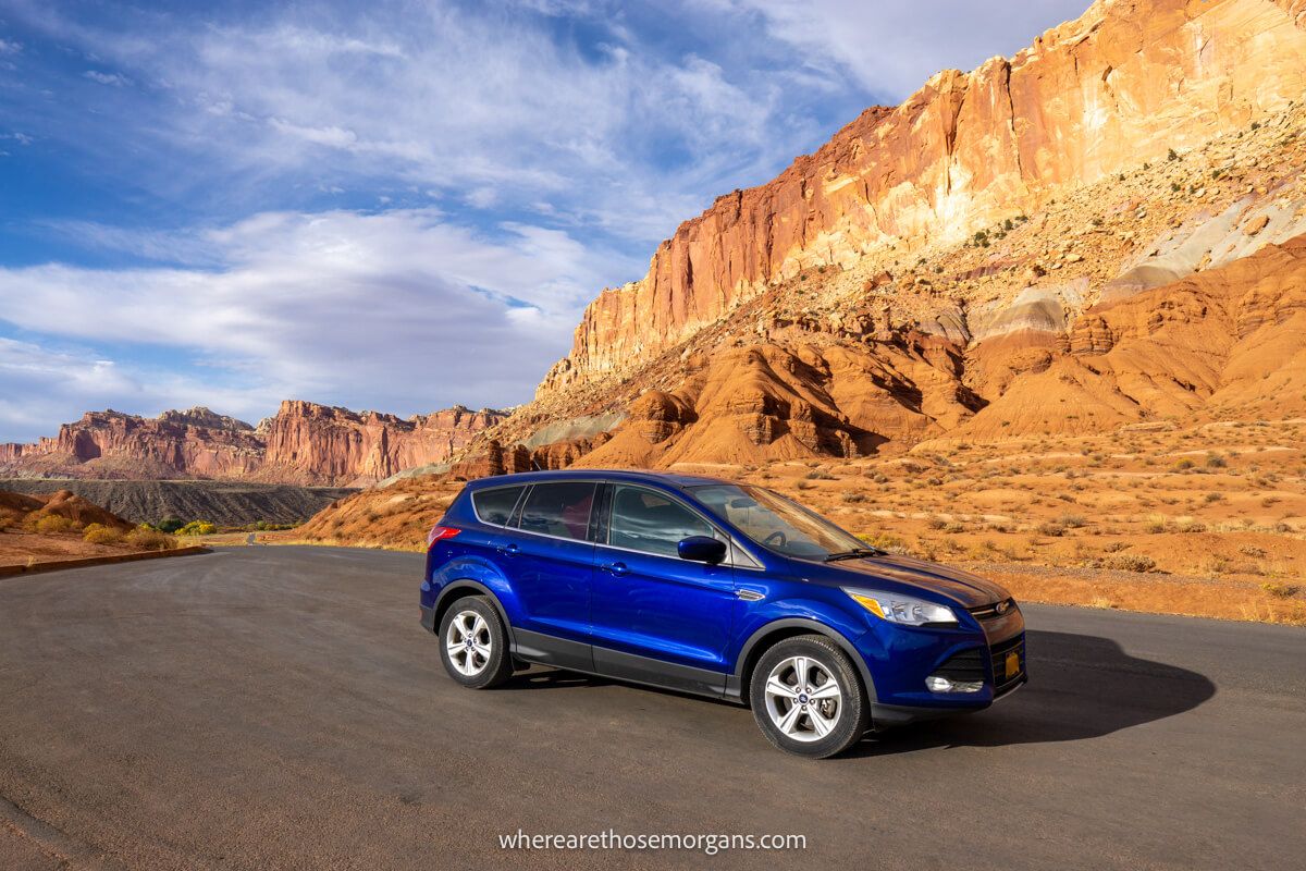
Capitol Reef is Utah’s quieter, smaller and lesser known national park on the famous Mighty 5 road trip circuit. We’re genuinely so glad we took on the extra driving to visit Capitol Reef because it turned out to be a much quieter and more relaxing part of our trip. Look, this park isn’t going to blow you away, but it’s photogenic and it’s great for families.
In this guide we show you the top Capitol Reef highlights along with a perfect one day itinerary, based on our experiences. Read more about us.
We first visited Capitol Reef in October 2019 as part of a three month US road trip. During our visit, we spent one amazing day exploring the stunning topography of this Utah national park. However, the one mistake we made was not giving ourselves enough time. In hindsight, we would have done things a lot differently.
So we created this guide to cater to every visitor because there are different regions in the park and it’s important to know how you want to spend your time before getting here. Essentially, we’ll tell you everything we wished we knew before visiting. Okay, let’s begin!
Note: Our content is reader supported and contains affiliate links. If you make a purchase through one of these links, we may earn a small commission at no extra cost to you and it helps us keep this site running.
Capitol Reef Overview
- State: Utah
- Website: nps.gov
- Address: 52 West Headquarters Drive, Torrey UT, 84775
- Campgrounds: 71 reservable sites
- Accommodation: No hotels in the park
- Popular activities: Hiking, camping, horseback riding, scenic roads, fruit picking, canyoning
- Annual visitors: 1.2 million visitors
- Best time to visit: Spring or fall for comfortable temperatures
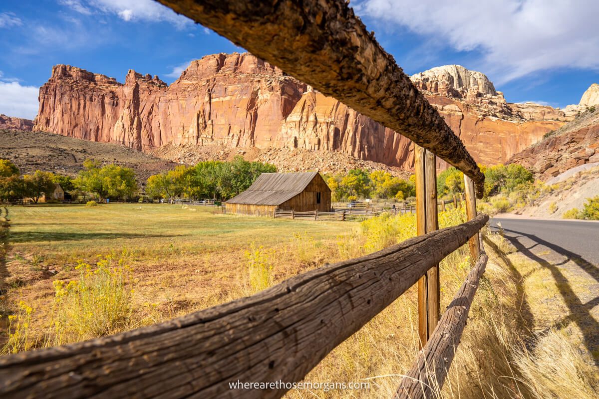
Capitol Reef is located within the Waterpocket Fold, a defining geologic wrinkle extending for nearly 100 miles from Thousand Lake Mountain to Lake Powell. This wrinkle, also called a monocline, was as formed between 50 and 70 million years ago due to large movement in the fault line resulting in a dramatic landscape filled with rugged cliffs, giant monoliths, natural stone bridges and beautiful dome formations.
It officially became a national park in 1971 to help preserve these stunning geologic features, the diverse plant and animal communities of red rock country and the homesteads of the earliest inhabitants. Today, you can visit petroglyphs from the Fremont Culture dating back to 300 and 1300 Common Era (CE).
The park gets it name from two distinct topographies. First, the white domes of Navajo sandstone are thought to resemble the US Capital building in Washington D.C. Second, early settlers were unable to pass the long ridges of the Waterpocket Fold which resembles reefs in the ocean. So put these both together and you get Capitol Reef.
How To Get To Capitol Reef
Most people visit Capitol Reef on a road trip through the American southwest because it’s nestled in south-central Utah. The boundary of the park is very long and skinny, running about 60 miles from north to south and 6 miles wide from east to west.
Highway 24 is the main road that cuts through Capitol Reef and this is where most visitors spend their time. If you’re planning to drive the Mighty 5 circuit, you’ll drive right this exact section. But if you want to explore the remote sections of the park, you’ll drive on rough roads requiring a 4WD vehicle.
Salt Lake City International Airport (SLC) is about a 3.5 hour drive (230 miles) from Capitol Reef and only a few hours drive from other national parks in the region. Harry Reid International Airport (LAS) in Las Vegas is another option if you’re visiting from further afield.
Here are driving distances to Capitol Reef from other popular places in Utah:
- Bryce Canyon National Park – 2 hrs 20 mins (120 miles)
- Arches and Canyonlands – 2 hrs 30 mins (150 miles)
- Zion National Park – 3 hrs (185 miles)
- Kanab, Utah – 3 hrs 20 mins (185 miles)
- Salt Lake City – 3hrs 30 mins (230 miles)
Where To Go In The Park
When visiting Capitol Reef, there are 3 main areas you can explore including the historic Fruita District, Cathedral Valley District (north) and the Waterpocket Fold District (south).
The Fruita District is the most-visited region of Capitol Reef because it’s located right off Highway 24 with many popular attractions such as the Fruita Barn, Gifford Homestead and petroglyph panel. You do not need a high-clearance 4WD vehicle to see Fruita so if you only have a few hours this is where we’d recommend you plan to visit.
If you’re looking for adventure, the Cathedral Valley District is located in the remote and rugged northern region of Capital Reef. To visit Cathedral Valley, you need a vehicle with high ground clearance. Sometimes cars without 4WD can navigate the roads, but conditions are extremely dependent on recent weather. The towering rock formations known as the Temple of the Sun and Moon and gorgeous scenic drives can be found here.
The southern section of the park is home to another very remote region known as the Waterpocket Fold District. As per the NPS, it’s accessible by most passenger cars, pickup trucks and vans, but the roads can become impassable after rain or snow. Most roads in this area are unpaved, rough and sandy. Highlights in the south include scenic drives and unique geology.
Torrey is the closet town on the west side of Capitol Reef. It’s only about a 15 minute drive from the western entrance and many visitors use Torrey as a primary gateway to explore the park. We highly recommend taking Scenic Highway 12 through Escalante and on to Bryce Canyon when you are ready to leave the park.
Travel Tip: If you plan to visit the remote sections of the park, it might take hours or days for help to arrive should you need it. Be sure to carry extra food, water, gas, clothing and emergency supplies. Day time temperatures in summer can reach 100 °F + and winter nights are often below freezing.
What To Do In Capitol Reef National Park
Depending on how much time you have will drastically change your itinerary. For those visitors who only have a few hours, we recommend focusing on the Fruita District, but if you have a full day or a few days, you should explore the remote regions. We’ll cover the Fruita District in detail and then we’ll show you the highlights of Cathedral Valley and the Waterpocket Fold.
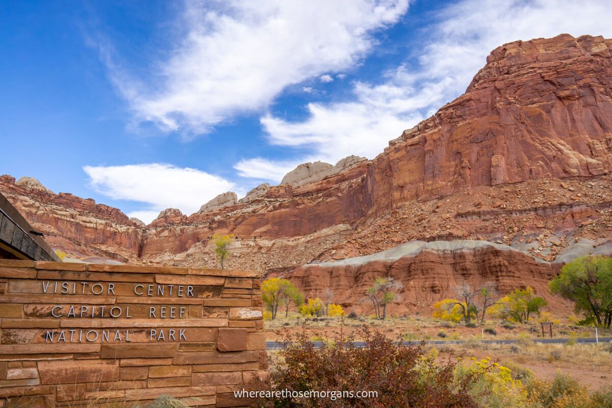
If this is your first time at Capitol Reef, we recommend making at stop at the visitor center because you can ask questions about road conditions and learn more about the region. Many of the top attractions are located within close proximity to this building so it sets you up for the perfect visit.
Without further ado, here are unique things to see in the Fruita District:
1. Capitol Reef Visitor Center

Capitol Reef National Park is a 24 hour park meaning it’s open all day, everyday. The visitor center is also open year round from 8:00am to 4:30pm with extended summer hours, but it’s closed on some federal holidays.
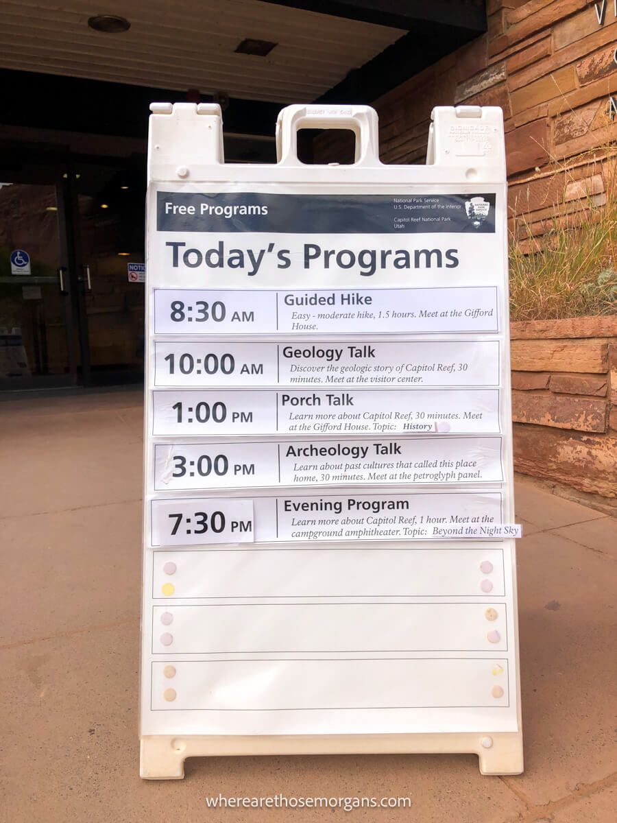
At the visitor center, you can watch an orientation movie, view informational exhibits, shop in the bookstore and ask questions. There is also a picnic area nearby with restrooms, grills, picnic tables and drinking water. If you’re planning to visit the remote regions of the park, be sure to speak with the rangers because they will have updates on current conditions and potential hazards.
Travel Tip: Fill up your water bottle at the visitor center before venturing into the park for the day. You’ll also find water stations at the picnic area, Gifford House and Fruita Campground.
2. Look For Rock Formations

There are various rock formations to keep an eye our for when visiting Capitol Reef. In Fruita, you should look out for the Castle and Capitol Dome.
The Castle is a stunning rock formation located near the main visitor center. It’s an easy thing to do at Capitol Reef because it’s located directly across the street. There is technically an old hiking trail leading to the back of the Castle, but it’s no longer listed as an official hike so it’s best to observe this formation from a distance.
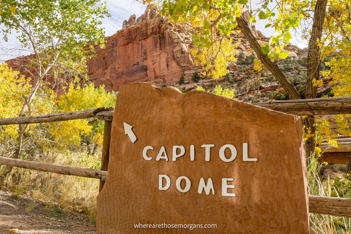
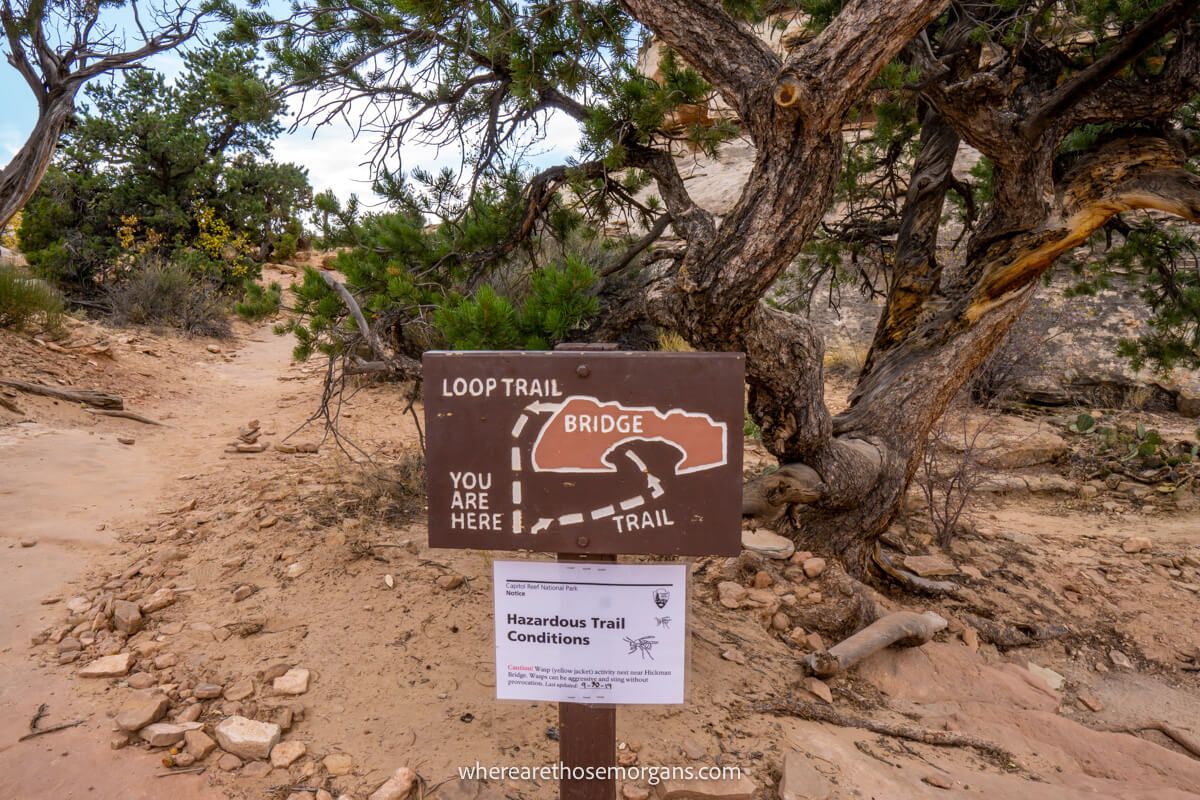
The next iconic landmark to watch out for is Capitol Dome. If you hike to Hickman Bridge, Capitol Dome can be seen directly from the trailhead. This formation is made from white Navajo Sandstone and its name comes from the fact it resembles the capitol building dome in Washington D.C.
Travel Tip: You can only see Capitol Dome if you’re heading east on Highway 24 unless you stop at the trailhead.
If you continue down Highway 24 heading east, you’ll also see Behunin Cabin. Tabitha Jane and Elijah Cutler Behunin were two early settlers who filed a homestead claim around the Fremont River. They lived in this cabin for only a year because it was a difficult area to homestead.
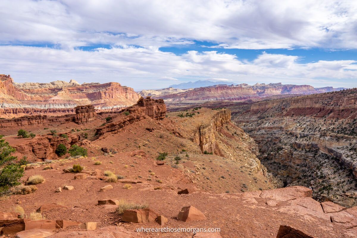
3. Capitol Reef Scenic Drive
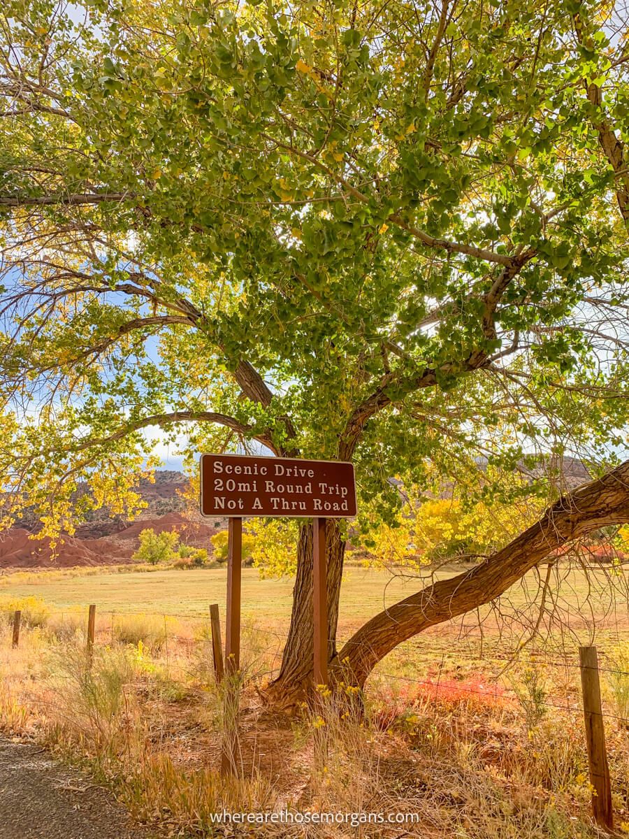
One of the most picturesque things to do in Capitol Reef is drive the 7.9 mile (one way) paved road because it showcases some of the best views in the park. It begins at the visitor center before continuing to Grand Wash and ending at Capitol Gorge Road. However, this scenic drive is under construction in summer 2024, so check the progress here before visiting.
There are 11 official viewpoints along this scenic drive highlighting moenkopi formations, solution pockets, the slickrock divide and an abandoned Oyler Mine. You can read about the stops in detail here, but it’s not a loop road so you’ll have to return the same way.
A few miles into the drive, you’ll reach the turn for Grand Wash Road which gives you access to the popular Cassidy Arch Trail. But as you continue, the paved road will eventually fork with two unpaved roads leading to the left or the right. Take the left to drive Capitol Gorge Road or take the right to drive Pleasant Creek Road.
We recommend taking the left onto unpaved Capitol Gorge Road. This scenic drive continues for another 2.3 miles twisting through a beautiful canyon of Wingate sandstone and its suitable for standard vehicles under 27 ft in length as per the NPS. Capitol Gorge Road will terminate at the Capitol Gorge hiking trail.
If you hike the Capitol Gorge Trail, it will pass through a wide canyon. Originally this was the only road through the Waterpocket Fold until Highway 24 was built. Many Mormon settlers passed through this area carving their names into the sandstone. The collection of names is known as the Pioneer Register and you can find it about 1.5 miles into the hike.
Travel Tip: To access the scenic drive, you’ll have to pay a $20 entrance fee via a self-pay station, but there is no charge for National Park Pass holders.
4. Gifford Homestead
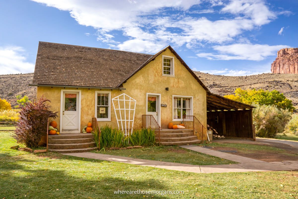
Early Mormon pioneers began settling in the historic Fruita District by the late 1800’s and this area is known as the heart of Capitol Reef. Originally built in 1908 by Calvin Pendleton, various families occupied the house throughout the years.
But the Gifford’s were the last family to inhabit the house from 1928-1969 before the region become a national park. On their farm they raised animals, ran cattle, gardened and grew an impressive orchard. Today, the house has been fully renovated to showcase the life of the early Mormon settlers.
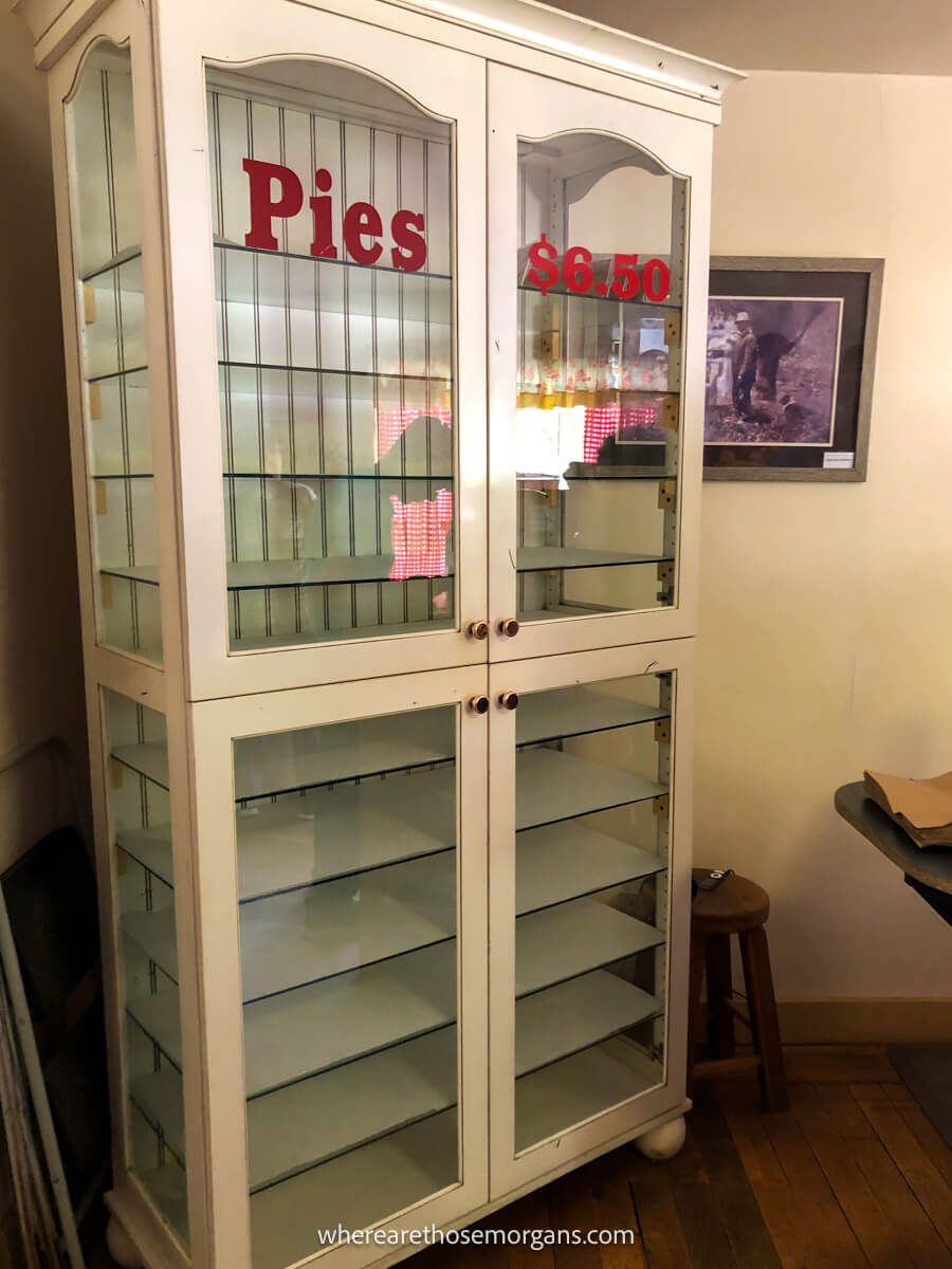
The kitchen has been converted into a store selling local handmade items such as books, jams, ice cream and famous pies. There are picnic benches just outside the entrance so this is a great spot to enjoy some lunch. The Gifford House is open from March 14 (Pi Day) to late November and you can check the hours here.
Travel Tip: The pies go quickly in the Gifford House so arrive early in the day to grab one before they sell out!
5. U-Pick Fruit
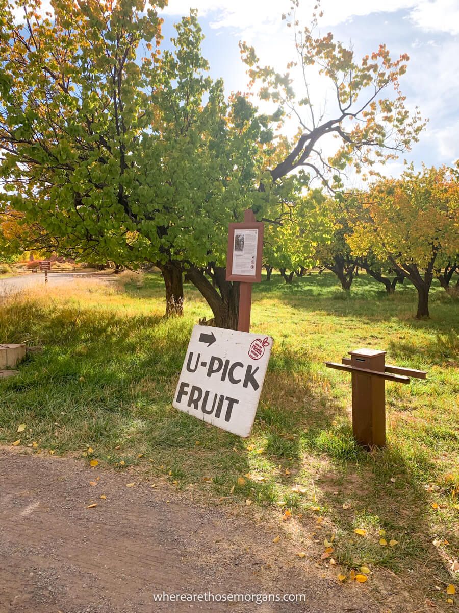
One of the most unique things you can do in Capitol Reef is harvest your own fruits. Look for orchards with “U-Pick Fruit” signs because as long as the fruit is in season and the gate is unlocked, you can enter the orchard to pick fruit.
The Fruita River Valley was very important for the Latter-Day Saints because it was extremely fertile land. From the 1880s to 1960s, they planted thousands of fruit trees which provided both food and a steady source of income to the families in Fruita.
There are 1,900 trees in the orchards of the national park and they are now protected under the Fruita Rural Historic Landscape. Park staff maintain the orchards using the same heritage techniques.
All fruit must be paid for by a self-pay station and scale located near the entrance of the orchard. Click here to see an orchard map and harvesting times. During our visit, we could pick apples so we highly recommend it if you have time.
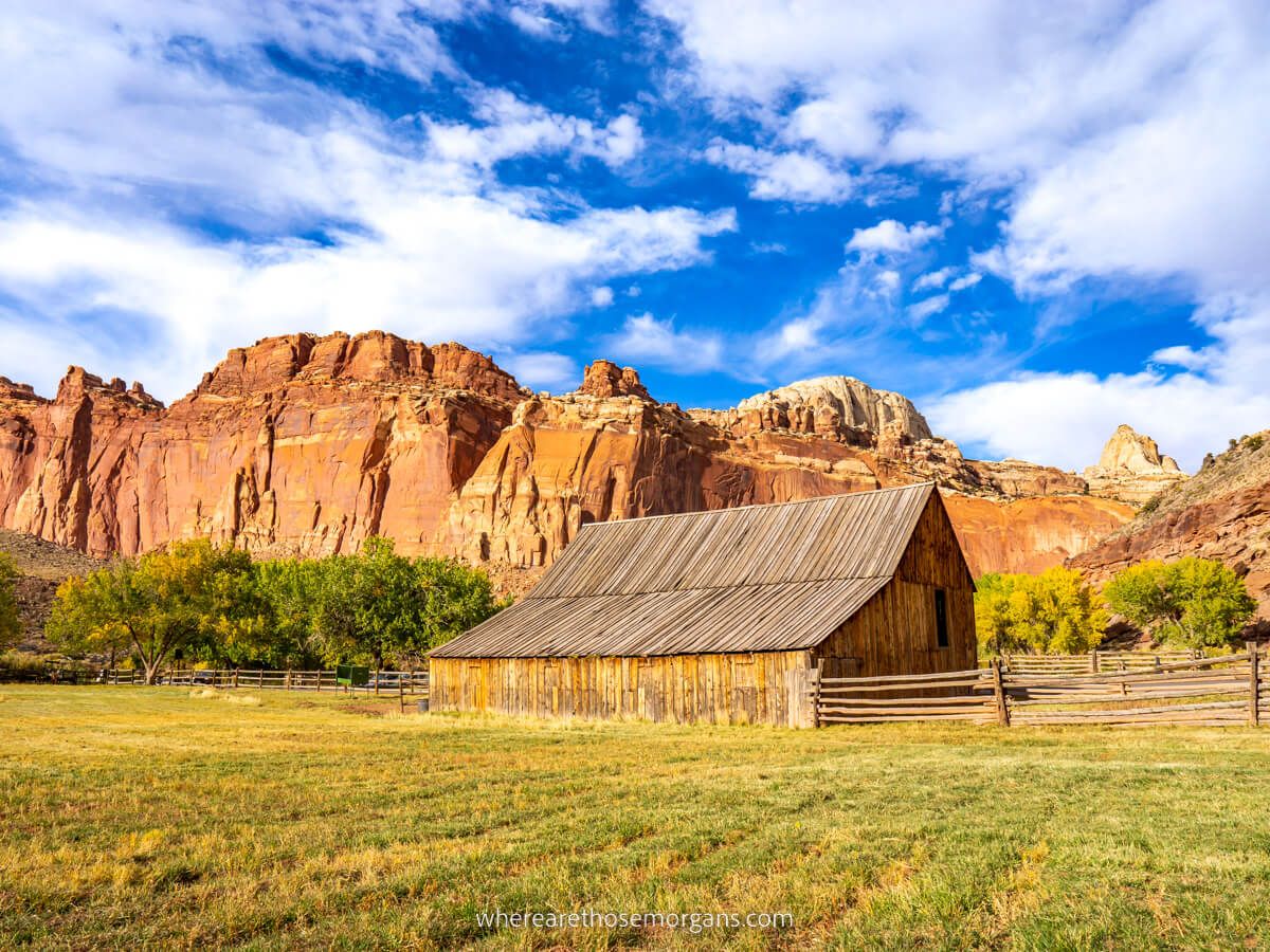
6. Fruita Barn
The Fruita Barn is our must see attraction in Capitol Reef National Park. It was the main reason we made the drive to the park because it’s incredible photogenic. We think the Fruita barn is worth the visit alone if you enjoy photography as a hobbyist, but if you’re a pro, the barn is a must visit on a wider Utah road trip.
While it’s less famous than John Moulton and T. A. Moulton barns on Mormon Row in Grand Teton, Fruita barn offers an entirely different background and we promise it will not disappoint. Get creative by moving around the area to find new ways of composing photographs including the fence, road, grass and rocks in your frame.
7. Fruita Schoolhouse
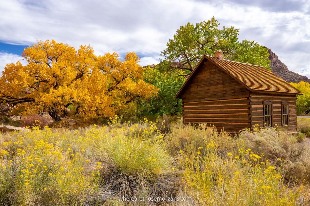
The Fruita schoolhouse is a tiny wooden structure surrounded by colorful trees, not far from the visitor center. It was once the only public building in the Mormon settlement and has continued to be used for education.
Park rangers run classes explaining geology, history and archaeology so be sure to check the days free programs occur at the visitor center. When we visited, the building was full of tourists learning about the history of the park.
We loved how striking the wooden building appeared when surrounded by radiant autumnal foliage colors. In our opinion, Capitol Reef has some of the most vibrant fall foliage colors of among the Utah Mighty 5 national parks circuit.
8. Fremont Petroglyphs
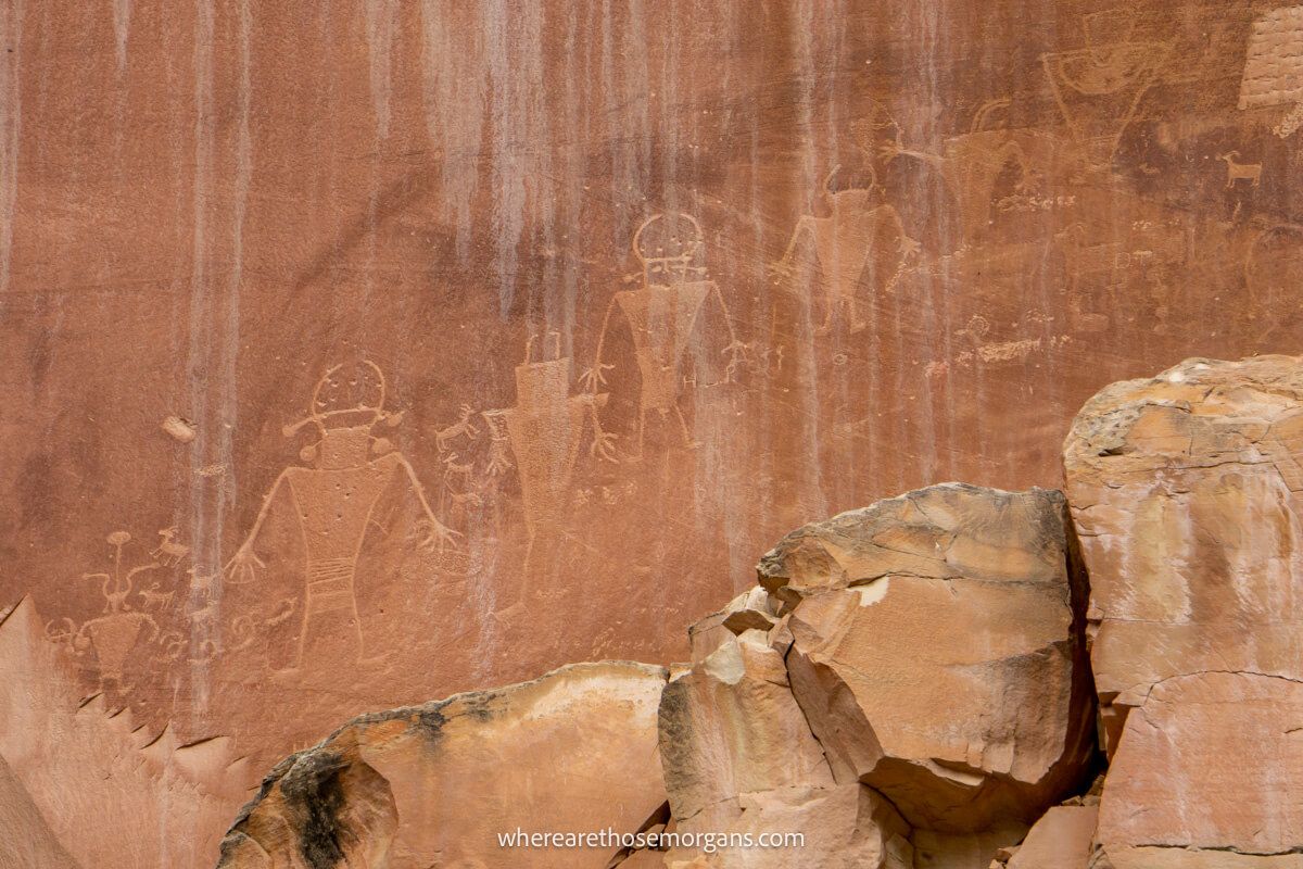
Along the drive on Highway 24, you can easily visit the Fremont Petroglyphs. Two wooden boardwalks lead to a high orange rock face with carvings etched into the rock. Just look for a small parking lot located between the Hickman Bridge and the Fruita District.
You can see the petroglyphs from the parking area but it’s worth getting a bit closer if you’ve never seen petroglyphs. Bring a pair of binoculars or a zoom lens to get a closer view and read the information signs about the history of the ancient culture.
Travel Tip: The harsh bright sun during the day can make it difficult to see the drawings so visit in the early morning or late afternoon to see the petroglyphs at their best.
9. Goosenecks And Sunset Point
Goosenecks Overlook and Sunset Point are two relatively easy hikes ending in dramatic canyon views. Both of these viewpoints can be reached via Highway 24. If you enter from the west, it’s just past the main entrance sign.
On Highway 24, look for a sign indicating Panorama and Sunset Point. Take the turn down the gravel road and the first stop you come to will be Panorama Point. You can admire the view and then can continue to the parking lot for Sunset Point and the Goosenecks Overlook. It’s a short drive, but its on an uneven dirt road so it might be uncomfortable in a low riding car. The road terminates in a parking lot for two trailheads.
The Goosenecks Trail is 0.2 miles round trip requiring very little hiking. This is the point where Sulphur Creek carved out a beautiful canyon over thousands of years, creating a path that resembles a gooseneck.
Sunset Point is a 0.8 mile round trip trail featuring the best view of the Capitol Reef National Park when the sun is setting. You can also see the Waterpocket Fold making it a unique spot in the park. There is no shade on this trail so plan accordingly.
It’s important to note that while Sunset Point shares a parking lot with Goosenecks Overlook, they are not accessed from the same trailhead. Sunset Point is the left trailhead and Goosenecks is the right trailhead. Do not cut across to the other trail after visiting one because this ruins the vegetation.
Hiking Tip: Plan to spend about 45 minutes to an hour hiking both Sunset Point and Goosenecks Overlook. You can visit Panorama Point either on the way in or out.
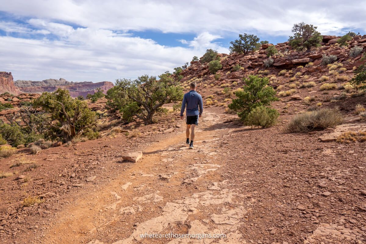
10. Go On A Hike
One of the best things to do in Capitol Reef is hike. The Hickman Bridge Trail is the most popular hike in the Fruita District, but there are about 15 day hikes you can experience in this region. We’ll also cover additional hiking trails in the remote regions later in our guide.
Here is a list of the popular hikes in the Fruita District in alphabetical order (distances are round-trip taken from the NPS website):
Cassidy Arch – 3.6 mile moderate hike through a deep canyon ending with a beautiful natural formation known as Cassidy Arch. It’s one of the popular trails and begins near the southern end of the Grand Wash. Plan for about 2-3 hours.
Chimney Rock – 3.6 mile moderate trail looping through the sandstone mountains. If you enter from the west on Highway 24, this is the first hike you’ll see. It features panoramas of the Waterpocket Fold and connects to the Rim overlook. Plan for 2 hours.
Cohab Canyon – 3.4 mile strenuous trail through a hidden canyon with stunning views over Fruita and Highway 24. If you want to see Fruita from above, this is the best hike for you and it takes about 90 to 120 minutes to complete.
Fremont River – 1.0 moderate trail following the Fremont River with a steep climb up to amazing views. It takes about 60 minutes to complete.
Grand Wash – 4.4 mile easy trail through a wide canyon. It’s similar to hiking the Narrows in Zion, but there is no water. This a long hike that takes about 2 hours to complete, but you can turn around at any point. Most people hike to the narrowest part of the canyon (known as the Narrows) about 1.0 mile in and then head back.
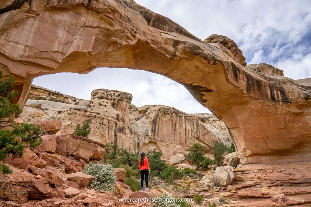
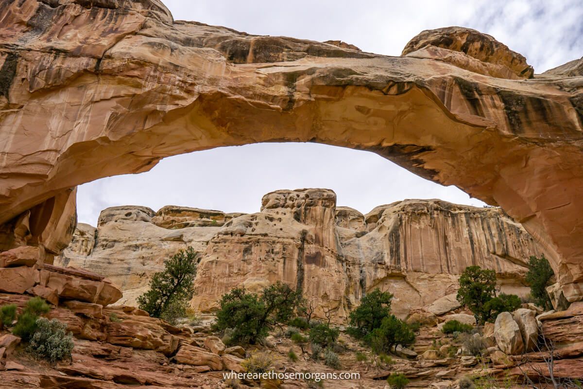
Hickman Bridge – 1.8 mile moderate trail beginning along the Fremont River climbing gently and then ending at a large natural bridge. It can be very busy and it takes about 60 minutes to complete.
Navajo Knobs – 9.5 mile strenuous hike leading to one of the best viewpoints in Capitol Reef National Park. It’s an extension of the Rim Overlook featuring a 360° mountaintop panorama and it should take about 6 to 8 hours to complete.
Rim Overlook – 4.6 mile strenuous hike up a cliff, but with epic views over Fruita and the Waterpocket Fold. There is minimal shade and it should take about 2.5 hours to complete.
11. Cathedral Valley
If you’re looking to get away from the crowds, Cathedral Valley is the remote northern section of Capitol Reef. Few visitors travel out this way and this is why some visitors love it. The NPS recommends vehicles with 4WD and high clearance to access this area and you should always check road conditions before heading out this way.
Here are highlights of Cathedral Valley:
Cathedral Valley Loop – This 58-mile scenic drive is one of the most popular things to do in this district, but there are no paved roads. Without stopping, it takes about 6 to 8 hours to complete, but if you add overlooks and hikes to your itinerary, this loop will take an entire day. Most visitors attempt the Cathedral Valley drive clockwise by starting at Hartnet Road and then continuing on to Hartnet Junction. Click here to see a map with official driving distances.
Benonite Hills – Found along Hartnet Road and similar to banded hills you can see in Badlands National Park, the Benonite Hills appear red, purple, gray, brown and green.
Upper and Lower Cathedral Valley – This is where you’ll find enormous sculptured monoliths including the Walls of Jericho and the Temples of the Sun, Moon and Stars.
Glass Mountain – Look for a large, exposed mound of selenite crystals commonly found in the bedrock of the park.
Gypsum Sinkhole – Created by the reverse process of Glass Mountain, ground water has dissolved this gypsum plug leaving a large cavity of nearly 50 feet deep.
Hiking is popular in Cathedral Valley, but it’s along backcountry trails through vast desert, gorgeous monoliths and volcanic dikes. For a full list of trails, visit the NPS website and keep in mind these are not official maintained trails so you may encounter obstacles. Along the south end of the Hartnet Road near Highway 24, vehicles must cross the Fremont River.
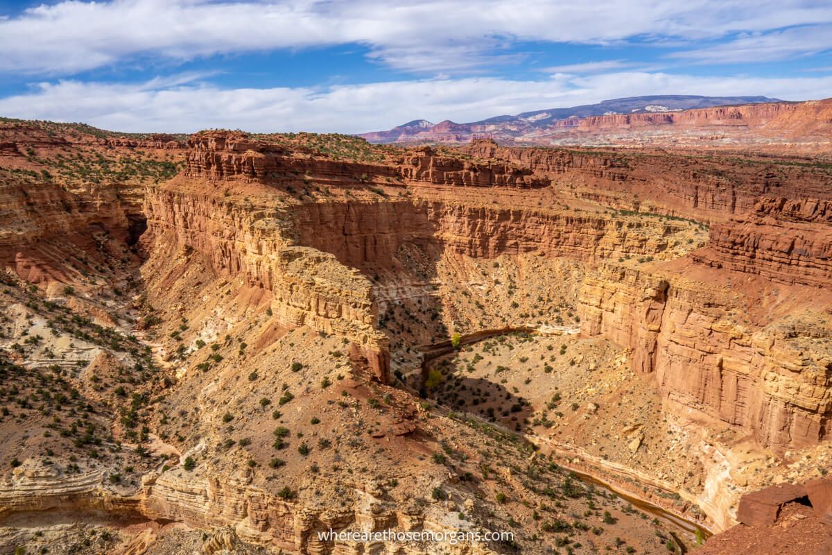
12. Waterpocket Fold
The Waterpocket Fold district is located in the remote southern section of Capitol Reef. Unique geological features include the Navajo and Page sandstones, Bentonite clay, Carmel formation, Cliffs of Mancos Shale and Wingate sandstone.
Just like the Cathedral Valley, this is a less visited region. It can be accessed by most passenger cars, but you need to watch road conditions prior to visiting. Precipitation can leave roads very slick, washed out and impassable.
Here are highlights of the Waterpocket Fold:
Loop The Fold – Another popular scenic drive, this 124 mile loop continues around the Waterpocket Fold and it will take about one full day. From Highway 24, take Notom-Bullfrog Road and drive south to Burr Trail Road junction. It starts off as a paved road, but will eventually turn to gravel. Notom-Bullfrog Road has numerous slot canyon hikes and the Burr Trail switchbacks offer incredible views including the Strike Valley Overlook. Click here to see a map with official driving distances.
Oyster Shell Reef – Along Notom-Bullfrog Road, this dense old reef features 100-million year old fossilized oyster shells.
Valley Strike Overlook – Known as one of the most unique viewpoints in the park, you can see 150 million years of geology in one stop. If you drive the loop, you’ll pass right by it or you can access it from Burr Trail Road. From the parking lot, it’s a 0.9 mile round trip hike and the trail for the Upper Muley Twist Canyon also begins here.
Travel Tip: From the Strike Valley Overlook, a paved road leads to Grand Staircase-Escalante National Monument. If you loop the fold, you’ll enter various canyons before arriving in Boulder. From here, you can take Highway 12 north until you reach Torrey and return to Capitol Reef National Park.
Capitol Reef’s Waterpocket is the most challenging hiking district. You’ll find hikes ranging from one hour trails to multi-day backpacking routes. It’s an extremely remote region so navigation skills are required. Do not rely on your phone and rock cairns to mark the way.
Some of the most popular backcountry canyon hikes in this region include Upper Muley Twist Canyon, Lower Muley Twist Canyon, Halls Creek Narrows as well as Burro Wash, Cottonwood Wash and Sheets Gulch Slot canyons (these 3 are located close to one another). You’ll find a complete list of Waterpocket Fold hikes here.
Hiking Tip: Flash flood season runs from July to September. Before hiking in slot canyons, it’s critical to check weather conditions because there may be no escape if you encounter heavy rain.
How Many Days Do You Need At Capitol Reef?
For the full experience, we’d recommend spending 2-4 days in Capitol Reef National Park. This way you can hike most of the trails and experience the scenic drives in the two remote sections of the park. But realistically most visitors will only spend half a day to a full day here. We’ve broken down each time frame into what you should not miss.
So if you only have a few hours, we recommend sticking to the historic Fruita District and taking in the sights along Highway 24. This includes Panorama Point, Sunset Point, Goosenecks Overlook, Fruita Barn, Gifford Homestead, Fremont Petroglyphs and a hike to Hickman Bridge.
With a full day in Capitol Reef, you can see all the points of interest along Highway 24 and drive the scenic road near Fruita including Capitol Gorge Road. You’ll have time to add on another hike such as Cassidy Arch, Cohab Canyon or Grand Wash. If you’re traveling with kids, you could also attend one of the ranger led programs. We think this itinerary makes the perfect addition to any Utah road trip and we’ve included a full itinerary next.
If you have two days in Capitol Reef, begin with our one day itinerary and then choose to visit Cathedral Valley or the Waterpocket Fold with your remaining day if you have the right type of vehicle. Add longer hikes and visit both of the remote regions if you have several days.
For those visitors who’d rather someone else drive through the remote regions of the park, check out these guided tours:
One Day Capitol Reef itinerary
Unless you’re coming from Moab or Denver to the east, you’ll enter Capitol Reef by the west entrance close to Torrey. Plan to arrive as early as you can to beat the crowds and heat. If you don’t like to drive in the dark, be sure to leave enough time to drive to Bryce Canyon in daylight.
Morning
As soon as you see the gorgeous red orange rocks you’ll want to pull over because it’s a natural reaction. However, resist the temptation and continue to the visitor center. Check out the ranger led programs for the day to see if you would like to join any. Head straight to the Fruita District to explore the Gifford Homestead and grab a pie if they are still available.
If you visit during the right season, find an orchard with the “U-Pick Fruit” sign and pick some fruit to snack on later in the day. The orchards are located right next to the Gifford Homestead.
This is also your chance to photograph the Fruita Barn. If you’re a hiker, you could also head to the Cohab Canyon Trail which begins near the Fruita Barn. If you don’t want to hike, jump back in your vehicle and take the scenic drive to the south. With enough time, you could venture up to Grand Wash or Capitol Gorge.
Once you have completed the hike and / or the scenic drive, stop by the picnic area near the Gifford House to enjoy some lunch.
Afternoon
After eating, drive back to the visitor center and take the other road at the fork towards Highway 24 as part of your afternoon itinerary. Your first stop will be the Fruita Schoolhouse. Even with no ranger program, this is still a beautiful spot to photograph and explore.
As you continue along Highway 24, the next point of interest will be the Fremont Petroglyph site. This is will be a quick stop, but don’t forget your binoculars to see the rock images in greater detail. Continue along the same road until you reach the Hickman Bridge trailhead. Crack out the hike and get back into your vehicle because it’s time to head west.
Near the Capitol Reef entrance sign, there will be a turning on the left up to Panorama Point, Goosenecks and Sunset Point. If you like to take photos with park entrance signs, this is a good time to snap a souvenir photo.
If it’s not too late in the day, take the turn and drive up the bumpy road. Enjoy the sunset from the stunning viewpoints and make your way back to your vehicle. Head down highway 12 towards Bryce Canyon. Aim to leave at least 3 hours before sunset if you want to avoid driving this distance in the dark.
Travel Tip: Visitors can purchase baked or canned goods at the Gifford House from spring to fall season (March to October). We brought our lunch when visiting because there are no restaurants anywhere in the park.
Where To Eat + Stay
One of the downsides to visiting Capitol Reef is there are no accommodation options located directly inside the park. So most visitors to use the nearby town of Torrey as a base when exploring the area.
Popular hotels nearby:
- Capitol Reef Resort – Luxury resort on 58 acres with stunning views and pool
- Broken Spur Inn – Popular covered wagon stays with breakfast included
- Cougar Ridge – Top rated ranch with beautiful rooms and animals
- Austin’s Chuckwagon Motel – Basic rooms with onsite market
- Red Sands Hotel – Amazing views, fire pit, indoor pool and spa
Here are the best restaurants in Torrey, Utah:
- Wild Rabbit Cafe – Cafe with organic and vegan options
- Capitol Burger – Food truck with great burgers
- Broken Spur Steakhouse – Top rated American western cuisine
- Chak Balam – Popular Mexican restaurant
Camping
Since there are no hotels, campgrounds are your only option if you want to stay inside the park boundaries.
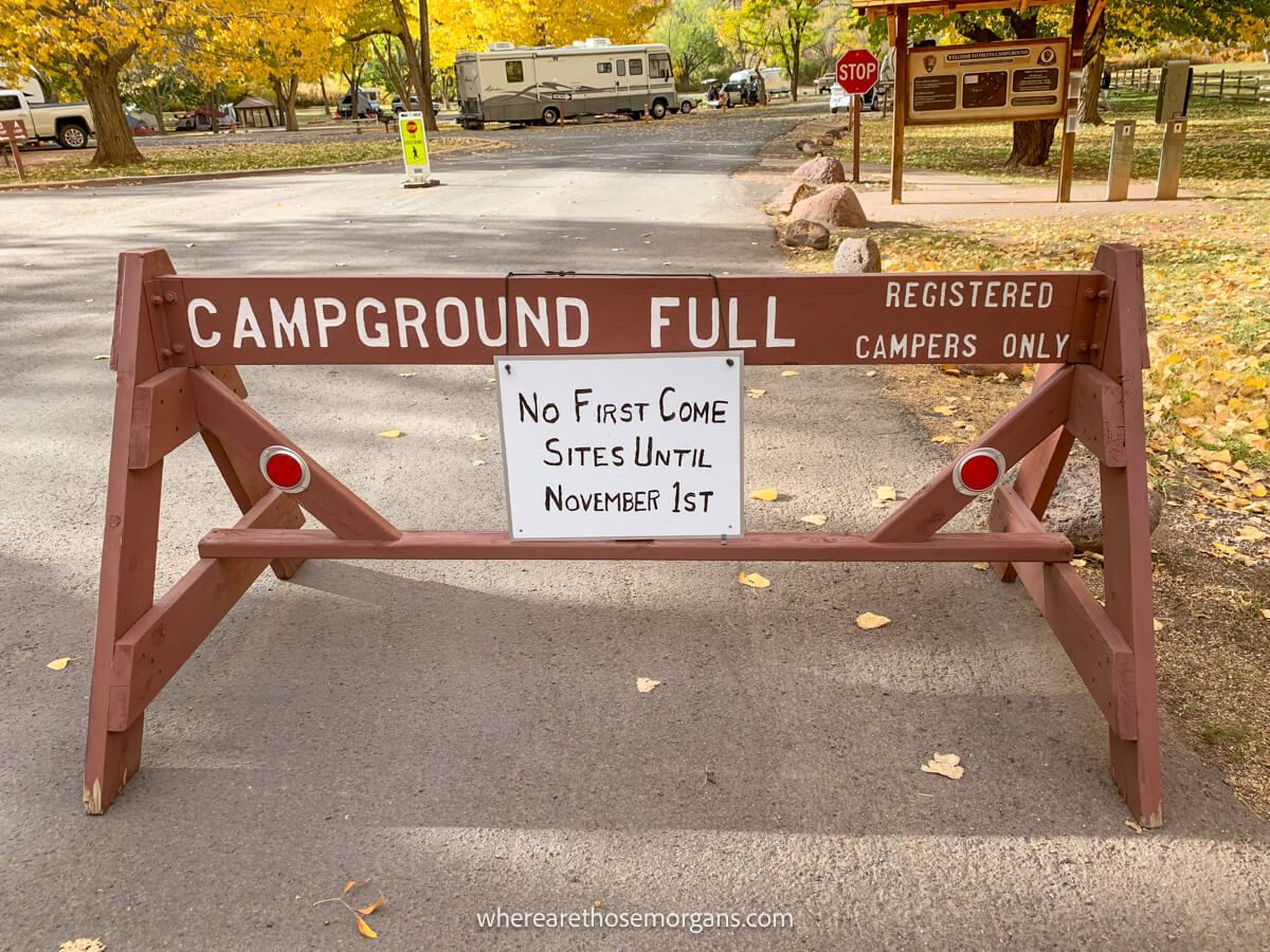
The only developed campsite in Capitol Reef is in Fruita. It’s adjacent to the Fremont River and close to the Gifford House. Visitors must book a reservation from March 1st – October 31st on Reservation.gov for $25.00 / night.
When we visited in mid-October, the Fruita campsite was completely full. Each campsite has a picnic table with fire ring. There is an RV dump station and potable water fill station near various entrances. Only three sites have electrical hookups for medical devices only.
Cathedral Valley and Cedar Mesa are two undeveloped campgrounds in the park. These campgrounds offer no services except pit toilets because they’re located in remote locations.
The Cathedral Valley campground sits about 7,000 feet (2,133 m) in elevation about half way on the Cathedral Valley Loop Road and a high clearance 4WD vehicle is necessary. While the Cedar Mesa campground sits at 5,500 feet (1,676 m) in elevation about 23 miles south of Highway 24 along Notom-Bullfrog Road. Two wheel drive vehicles can typically access this campground.
Can’t find a campground? Use our exclusive 30 day free trial of The Dyrt PRO to find both free and paid campsites or use Dyrt Alerts to snag a spot at a sold out campground nearby.
Capitol Reef Map
Click or touch the map below to activate, zoom in and out, and scroll around. If you’d like to see a bigger version, click the “view larger map” icon in the top right, and if you’d like to see anything specific, click the arrow and square icon in the top left.
Map key:
- Red – Fruita District
- Orange – Cathedral Valley
- Green – Waterpocket Fold
- Blue – Hotels
- Purple – Restaurants
We’ve added points of interest to all three sections of the park so you can find everything you need including hotel and restaurant locations too.
Tips For Visiting
Before you head to Capitol Reef, we want you to be prepared so here are a few important tips for visiting:
- Most of the scenic drives in the park require a high clearance 4WD vehicle. If you don’t have this type of vehicle, stick to the paved scenic drive in the historic Fruita District.
- Always check the current conditions. This is essential for road closures, weather problems and slot canyon safety.
- Capitol Reef is one of the best places to see the stars. It’s an International Dark Sky Park with minimal light pollution.
- Fill up on gas before entering the park. The closest gas stations are in Torrey to the west and Hanksville to the east.
- Visit in the spring or fall when temperatures are cooler. We timed our visit perfectly to see the vibrant bright yellow leaves contrasting against deep orange rock faces.
- Start hiking early in the day. This way you’ll avoid the heat and protect your skin from the sun.
- Bring extra food and water. Most visitors grab a bite to eat in Torrey or grab a pie at the Gifford Homestead.
- There is no fee to drive Highway 24. You can see this part of the park without paying an entry fee, but if you want to drive the Fruita Scenic Drive, it’s a $20 fee. Any visitor with an America The Beautiful pass can visit for no additional cost.
Travel Tip: If you’re driving Highway 12 between Capitol Reef and Bryce Canyon National Park, enjoy the views over Larb Hollow Overlook at sunset.
The Morgan Conclusion
We think Capitol Reef is worth visiting because it’s one of Utah’s smallest and lesser known national parks. It offers many unique activities and fun hiking trails of various difficulty.
This is a great national park for children because it’s filled with easy hikes, orchards for picking fruit, a paved scenic drive and an old schoolhouse for them to explore. For adventurous hikers or climbers, you can spend your time in the very remote regions of the park enjoying the various slot canyons, backpacking routes and 4WD scenic drives.
While the scenic drives in Capitol Reef are amazing, we think hiking is one of the best things to do in the park. From the numerous trails, you can get a bird’s eye view over various points of interest and explore the slot canyons. We think visitors can easily visit Capitol Reef in a few hours and accomplish most of the best bits, unlike Zion, where you need at least two full days to do see the best sections.
You can see our favorite Capitol Reef photographs or Capitol Reef itinerary video for more inspiration after reading this guide. Avid photographers will enjoy snapping shots of the iconic Fruita Barn and kids will love running through orchards picking fruit. We’ve also included 2 trails from Capitol Reef in our guide to the 25 best hikes in Utah, so don’t miss them.
More From Utah
- Best places to visit in the state of Utah
- Photography guide to Capitol Reef
- Best photo spots in Bryce Canyon
- Hiking Queens Garden Navajo Loop
- Best things to do in Kanab
- Where to stay in Zion national park
- How to visit Arches and Canyonlands
- Mesa Arch in Canyonlands
- Tips for visiting Coral Prink Sand Dunes
Want more Utah content? Head over to our Utah Travel Guides to explore the Mighty Five National Parks and beyond.
We hope our detailed Capitol Reef National Park guide helps with planning your visit!
Please let us know if you have any questions in the comments below.
Happy Travels,
Mark and Kristen
Enjoy this guide? Pin it for your visit!
All Rights Reserved © Where Are Those Morgans, LLC. Republishing this article and/or any of its contents (text, photography, maps, graphics, etc.) in whole or in part is strictly prohibited.

Mark and Kristen spent 6 years traveling the world, visiting over 40 countries across 4 continents and more than 30 US states. They created Where Are Those Morgans in 2018 to help others plan the best possible vacations by writing authentic travel and hiking guides based on their real experiences.
Since the arrival of baby Maya in late 2024, Mark and Kristen’s extensive travels have slowed down but they still take plenty of trips. Where Are Those Morgans now helps millions of travelers each year to visit new places and hike new trails through information-packed blog posts and expert travel guidebooks. Read more about Mark and Kristen.
We are visiting Capitol Reef tomorrow morning. Staying at the Rim Rock Inn tonight. Thanks for the helpful advice we will put it to good yse
Thank you for letting us know, David. We hope you enjoyed your visit to Capitol Reef and Utah 🙂
Great advise going here in October.Thanks ?
Thanks, Thomas. Have a great trip!
Great info.
Thanks, Thomas!