
Smartphone hiking and outdoor apps have significantly advanced over recent years and several have become seriously popular resources. It’s amazing how much information we can get in the palm of our hands today. But with so many apps on the market offering different capabilities, how do you know which ones to choose?
Because let’s face it, the right app can significantly help you find new trails, navigate offline, track your progress, and they may even save your life. In this guide we show you our 10 favorite hiking apps to help you download the best ones for your next adventure. Read more about us.

As a popular hiking blog, we love to share our first hand experience from hiking trails both in the US and around the world. We’ve completed some pretty epic trails including Tour du Mont Blanc, W-Trek in Chile and the Inca Trail to Machu Picchu. During these hikes, we used many of the apps on this list.
We’re passionate about sharing tips to help other hike responsibly and stay safe. Planning a successful hike takes a lot of preparation and skills, which is why we decided to write this guide. There are so many tools you can use to help you easily navigate a new trail. Okay, let’s begin!
Note: This article may contain affiliate links. If you make a purchase using one of these affiliate links, we may earn a small commission at no extra cost to you. Thank you!
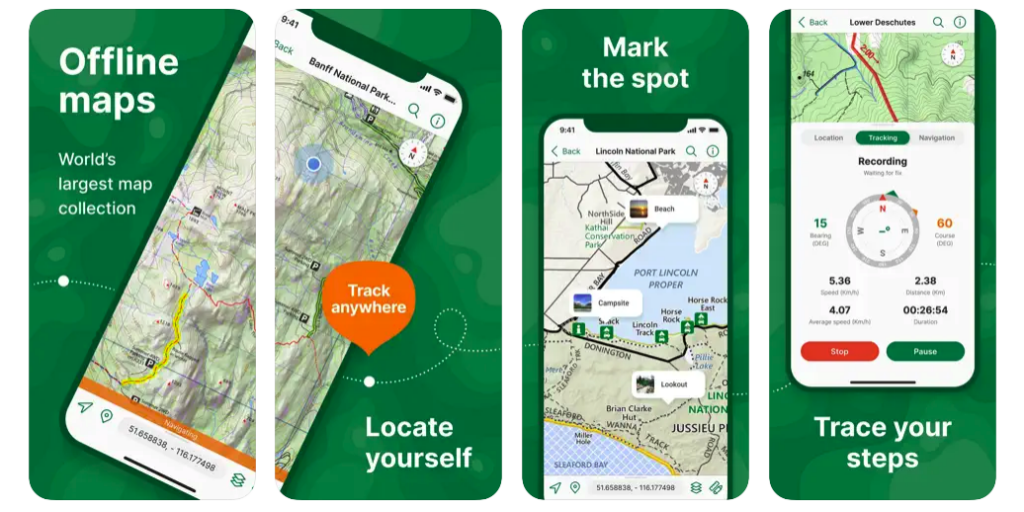
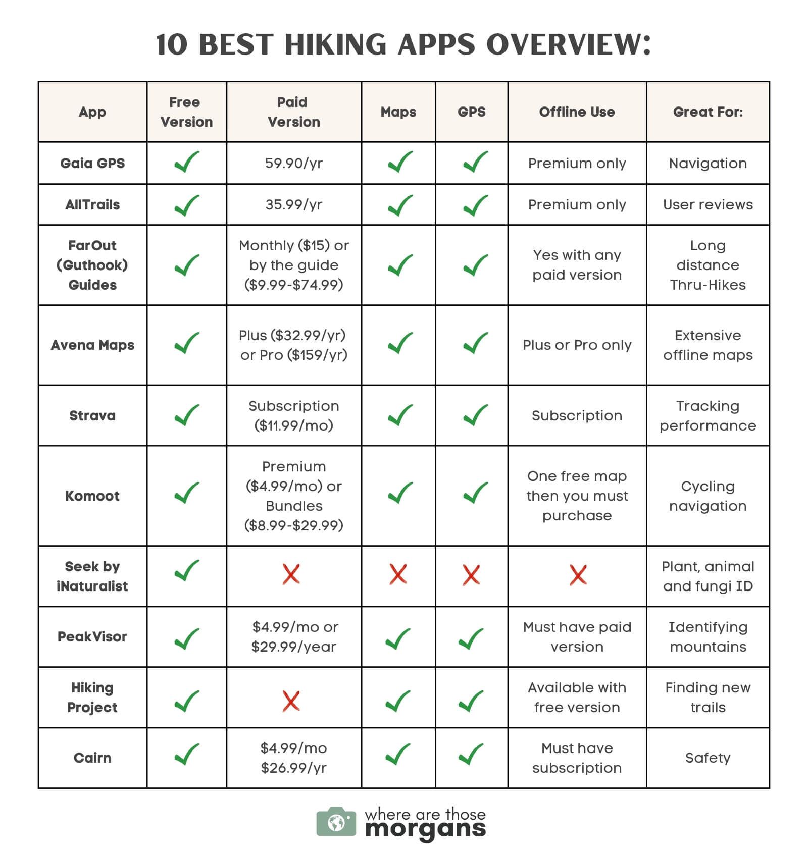
Offline Hiking Map Example
Before we get into our list of the best hiking apps, we thought it was important to show you the benefits of using an offline map. Our example uses the Gaia GPS Premium version, but many of the apps we discuss will have similar capabilities.
In the photo below, you’ll see a dotted line connecting the top photography spots at the end of a hike to The Wave in Arizona within the Gaia GPS app. This is what the map looks like directly after downloading. We like Gaia GPS because points of interest are often included so you won’t miss important sights during a hike.
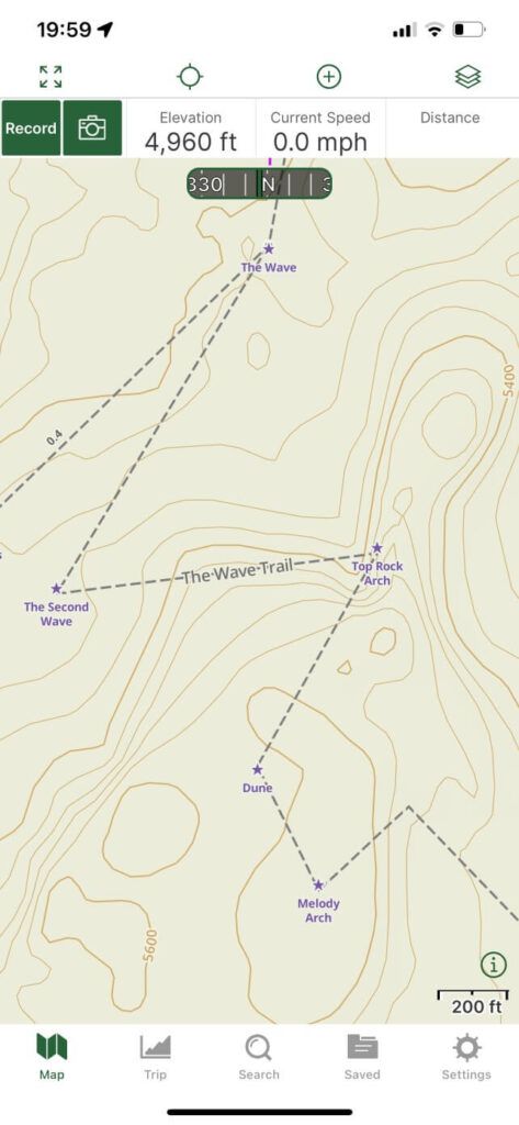
Prior to hiking the trail, we knew there would be no internet so we downloaded the map offline directly within the app on our phone. The next day, we followed the lined trail and successfully found the Wave despite having no service.
In the second photo, you’ll see a screen shot of our Subway hike in Zion National Park using the same offline mapping system.
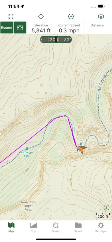
This time the map has a solid purple line with a large orange triangle, which shows our exact location. Since we only saw a few other people during this hike and had no service, it was very comforting to know our location at all times.
While these maps are a very useful tool, we highly recommend you never solely rely on your smartphone apps when hiking. Using GPS and tracking features very quickly drains your battery and you’ll need a plan if your phone dies. From our experience, using offline maps and tracking routes will last about 6-12 hours depending on how many features you use during the hike.
One of the easiest solutions is to carry a backup source of power such as a solar charger or power bank, but you should always plan accordingly with a paper map and compass just in case. Be sure you know how to use a compass prior to hitting the trails. If you’re new to hiking, you might like to read our beginner hiking tips.
Hiking Tip: During a long day hike, we only use one phone to navigate with an offline map. We keep the other phone turned off with full battery in case our first phone dies and we have an emergency.
Now, let’s find the best hiking apps on the market today:
1. Gaia GPS
- Cost: Free and premium version ($59.90/year)
- Available on: iOS or Android
- Free features: Record activities, plan routes, drop waypoints, follow your location, search for hiking trails
- Premium features: NatGeo trails illustrated, ability to download maps for offline use, access to additional layers such as cell phone coverage and water
We’ve used Gaia GPS since we started this blog in 2018. It currently has a 4.8 rating out of 5.0 with over 30,000 reviews making it one of the most popular apps for hiking. Compared to other platforms, we’ve always found Gaia GPS to be extremely accurate and it’s never led us wrong after hundreds of miles hiked. We think it’s the gold standard when it comes to smartphone trail navigation capabilities and it’s always been our number one recommendation for hikers.
The free version of Gaia lets you minimally track routes, find waypoints and look at topographical maps, but you’ll have to buy the premium version to unlock features such as offline capabilities and speciality maps for other countries. We love tracking statistics such as our elevation profile, distance on ascent or descent, average speed, moving speed and stopped time.
Unfortunately, Gaia GPS was purchased by Outside in 2021 and many users including us aren’t happy because the price has increased dramatically and users are now forced to have an Outside account upon log in. However, we’ve found most of the features have remained the same and we hope it continues this way. To get the most out of this app, you should use the premium version. Click here to save 20% on a Gaia GPS Premium membership ($47.92/year).
Pros: Extensive trip statistics, great free or premium plan, ability to find and organize trails, weather forecasts, extremely accurate GPS navigation
Cons: Offline use limited to premium version
2. AllTrails
- Cost: Free and AllTrails+ membership ($35.99/year)
- Available on: iPhone or Android
- Free features: Detailed hike descriptions, user-friendly interface, large audience of active users, ability to see recent reviews
- Pro features: Required to access most features, downloadable offline maps, lifeline capabilities, alerts for when you’re off route, real-time map overlays
AllTrails is another one of the most popular hiking apps available today. It was created in 2010 with a focus on outdoor recreation through the power of crowdsourcing. AllTrails is our most used hiking app next to Gaia GPS and we use it mainly to see recent reviews from other hikers. This platform is a great way to assess trail conditions and potential issues that others may have recently experienced.
One of the downfalls to AllTrails in our opinion is accuracy because maps are uploaded by users and may not always be correct. Sometimes a users route becomes popular, and several hikers begin to follow it blindly which may lead to them not having the best experience or missing interesting viewpoints.
We have the free version of AllTrails because we use Gaia GPS premium for navigation. But we love this app because you’ll truly feel like you’re part of a hiking community. You can sign up here for a free account to give it a try.
Pros: Ability to find trails based on tags, detailed hike descriptions, pet-friendly status, recommendations, reviews from other users, record hiking statistics
Cons: Best features locked behind pro version, crowdsourced maps not always accurate
3. FarOut
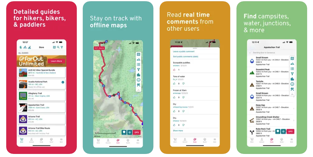
- Cost: Free, Monthly ($15.00/month) or pay by the guide ($9.99-$74.99)
- Available on: iPhone or Android
- Free features: Ability to search for trails
- Premium features: Offline maps, family and friends can follow with updates and check-ins, detailed waypoints, town resupply guides, elevation profiles
FarOut, formerly known as Guthook Guides, is a very popular app with detailed guides for long distance hiking, biking and paddling. It has a 4.8 out of 5.0 rating with almost 23,000 reviews so you can be confident downloading this app. We like FarOut because it gives you access to 35,000 miles of hiking trails and the maps are routinely updated. Other users also rave about the embedded trail alerts and reports about water sources.
This app is commonly used for thru-hiking long distance trails around the world such as the Pacific Crest Trail, Application Trail, Tour Du Mont Blanc and the W or O-Trek in Torres del Paine. When we hike longer distances, we purchase the individual trail guide and research our hike extensively using FarOut. If you’re planning small local hikes, this app might be a bit too much for your needs. Click here to create an account.
Pros: Detailed waypoints, town guides, offline map capabilities, ability to share location, create custom routes, great Gaia GPS alternative
Cons: Free app limited, must pay per guide, town guides can be outdated, some users report problems downloading maps
4. Avenza Maps
- Cost: Free, Plus ($32.99/year) or Pro Membership ($159.99/year) with additional in-app purchases
- Available on: iPhone or Android
- Free features: View maps, record activities, GPS tracking, notifications, downloadable sections of 3 maps up to 1 GB of storage
- Plus features: Import up to 20 maps at a time, satellite basemap layer included
- Pro features: Import and export shapefiles, unlimited geofences, priority technical support
Created in 2010, Avenza Maps is similar to Gaia GPS because it allows users to download maps for offline use. With a 4.8 out of 5.0 rating and over 110,000 reviews, Avenza is a popular choice for outdoor lovers due to the large amount of hiking, topographic, cycling, city, nautical, travel, and trail maps.
While Gaia GPS is still our top choice, we’ll occasionally use Avenza because we like their detailed maps from National Geographic, National Park Service, and the US Forest Service. You can locate your realtime GPS location even when offline. Other popular features include adding photos to locations and recording trips.
Pros: Very detailed volume of maps, ability to save placemarks and export data, GPS hike tracking, can layer on multiple maps
Cons: Multiple tiers of use can be confusing, difficult to search maps, no synchronization
5. Strava
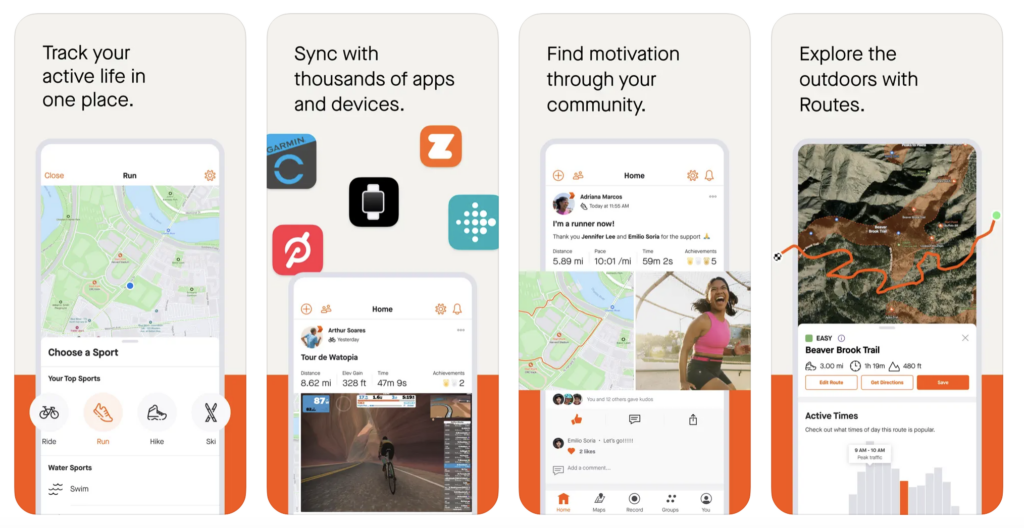
- Cost: Free or Subscription ($11.99/month)
- Available on: iPhone or Android
- Free features: Activity recording, beacon on phones
- Subscription features: Route planning, segment competitions, training log, personal heatmaps, goal setting
Strava is a very popular app used to track fitness by recording everything from runs, hikes, yoga workouts and bike rides. We think one of the biggest perks about this outdoor app is that users can sync progress with just about any device including Apple Watch, Garmin and Fitbit.
This app is different from the others on our list because it’s best for tracking performance. To get the most of out Strava, you’ll want to use it for setting goals. We love that you can track a hike or run and then compare it with previous times from the exact same route. If you want to work on your fitness level, Strava is the way to go. Another unique aspect is the segments feature so you can find safe places to run when traveling.
Pros: Fun to use especially in cities, can help you find new running or cycling routes, ability to share with others, great for motivation
Cons: More geared toward serious fitness enthusiasts, users sometimes complain about lack of privacy
6. Komoot
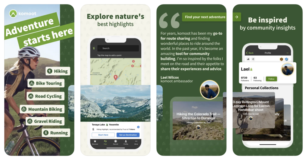
- Cost: Free or Premium ($4.99/month), Region Bundles ($8.99) or World Packs ($29.99)
- Available on: iPhone or Android
- Map features: Turn by turn navigation, offline functionality, weekly updates
- Premium features: Multi-day planner, sport specific maps, weather, live tracking, personal collections
Komoot is a popular app for cycling navigation, but it’s also a route planning app to help you explore a new region. When you sign up, you’ll receive one free single region so you can test the app and see how you like it. After the first region, you can upgrade to the premium version or purchase specific regional bundles.
We haven’t used Komoot much since there are so many other specific hiking apps on the market, but read the reviews to see how much cyclists and mountain bikers love it. A very popular feature is the turn by turn navigation so you’ll never feel lost. However, this app is only meant to help with navigation so there is no heart rate monitoring or information to show pace.
Pros: Turn by turn voice navigation, offline map capabilities, great for bikers and cyclists, multi-day trip planning
Cons: Regions can be small, occasionally suggests roads that are unsafe, trails sometimes missing
7. Seek by iNaturalist
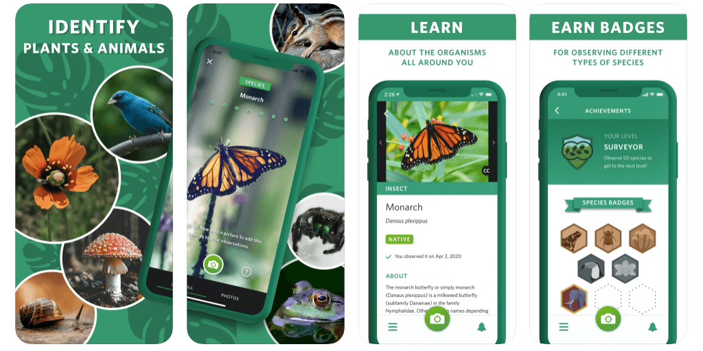
- Cost: Free version only
- Available on: iPhone or Android
- Free features: Ability to identify wildlife, plants, fungi and more
Seek by iNaturalist is an outdoor app for those who love nature. It uses the power of image recognition technology to identify wildlife, plants and fungi just by taking a photo. While this is not your typical hiking app, it’s one you should download for safety on the trails.
It’s a good app to help kids learn about different organisms and they can earn badges for observing different types of species. As adults, we love using Seek to see if we can properly identify plants or animals. Overall the app works well, but it sometimes can be difficult to get a clear photo to make a proper identification.
Pros: Great for kids, ability to identify many different organisms, free to use
Cons: No maps or trail descriptions, app requires very clear images for positive ID
8. PeakVisor
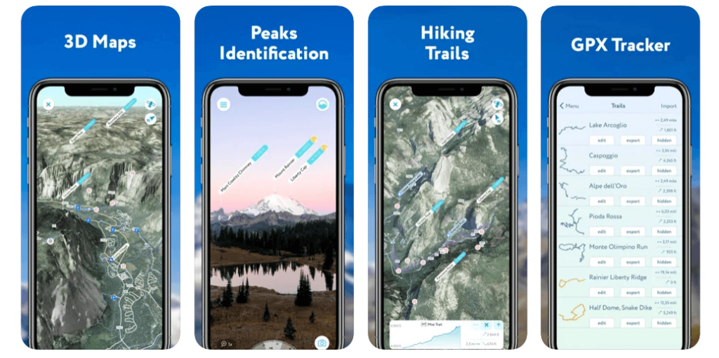
- Cost: Free, Monthly ($4.99/month) or Annual ($29.99/year)
- Available on: iPhone or Android
- Free features: Ability to 3D map your hike, ID mountains hundreds of miles away, use a GPS tracker to share your progress, plan hiking routes
- Paid features: Same features but no limitations and doesn’t require cell service or wifi
The PeakVisor app is perfect for hikers who love mountain trails. And unlike many apps on this list, it’s best used to identify mountain peaks with high precision terrain modeling. We love this app because you can easily gain insight to nearby mountains, hills and landscapes with a detailed profile each time.
So if you’ve ever been hiking and wondered what that mountain peak was in the distance, download PeakVisor and you’ll never have to wonder again. Mountain profiles typically include altitude, spanning mountain range, topographical info, additional photos and information pertaining to where it’s located. Other popular features include GPS tracking, schedules for cable cars, topographical 3D maps and monthly climbing challenges.
Pros: Mountain identification, plan hiking routes, GPS tracking, 3D topographical maps
Cons: Free version can be limiting
9. Hiking Project
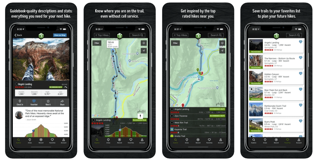
- Cost: Free
- Available on: iPhone or Android
- Free features: Large database, detailed trail descriptions, user contributions, offline functionality, exact location shown on trail, ability to check-in on trail
Hiking Project is one of the best free hiking apps. It’s a crowdsourced hiking app similar to AllTrails and backed by REI. This app shines because it offers very detailed descriptions of trails with a guidebook feel. You’ll find information about pass requirements or current trail conditions.
We like Hiking Project because it’s great for finding new trails. You can even add gems or points of interest to any hike you plan to do. New hikes are constantly added to their growing database featuring over 74,000 miles of trails. Offline capabilities are offered in this app, but we find this interface is not as easy to use as some of the other hiking apps on our list.
Pros: Detailed descriptions of trails, ability to search and save new hikes, completely free, good AllTrails alternative
Cons: No ability to track distance, mostly US based
10. Cairn
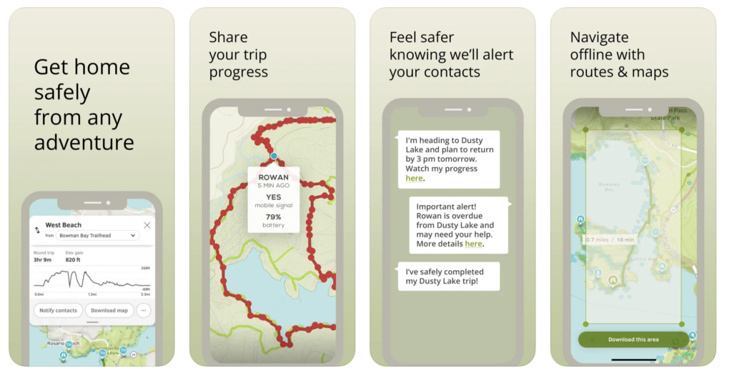
- Cost: Monthly ($4.99/month) or Annual ($26.99/year)
- Available on: iPhone or Android
- Free features: Maps, trails and cell coverage information
- Premium features: Live-tracking, trail statistics, GPS and offline maps, send updates to loved ones, customize your ETA based on recent activity
Last but not least, Cairn takes the cake when it comes to safety. You can easily share your plans and GPS location with loved ones who are designated as safety contacts. Take advantage of the 7-day free trial where you can try the premium subscription to see if your like it.
We like Cairn for the ability to see cell coverage. This app does offer GPS maps, but safety is the number one reason to download it. Many hikers use Cairn for peace of mind when exploring outdoors because their loved ones can easily track their progress and send updates if needed.
Pros: Real-time location sharing, safety contacts are notified when you’re past due, trail statistics
Cons: Does not rank hikes by difficulty which most other hiking apps do, key features locked by premium
Honorable Mentions
That concludes our list of the best apps for hiking, but below we’ve included a few more options for longer backpacking trips, camping and outdoor safety.
- CalTopo – Navigational abilities similar to Gaia and great for backcountry use
- First Aid – Step-by-step instructions for everyday first aid scenarios
- Google Maps – What we use to plot points of interest before any trip
- Maps 3D – Allows users to see actual dimensions of a route not just topography
- Mountain Project – Access to more than 300,000 climbing routes around the world
- Native Land – Learn about indigenous territories and languages
- onX – Premium backcountry app with hiking, backpacking and mountain biking trails
- Spyglass – A very high tech navigation app with a steep learning curve
- Star Walk 2 – Identify stars, planets and constellations in real-time
- Recreation.gov – Best for organizing reservations in US National Park
- The Dyrt – Our favorite camping app because it can help you snag reservations at sold out sites
- Topo Maps+ – Popular option for backcountry hiking trips
- Wikiloc – Topographical maps for up to 80 different activities and great for international trips
The Morgan Conclusion
Here’s a quick graph we put together so you can see all of the information we discussed in this guide easily.
What we like: Hiking apps are great tools to help people explore the outdoors. Some are free to use while others may require a paid version or additional in-app purchases. We think one of the best features is the ability to navigate offline because you can easily find your exact location without any cell service.
What we don’t like: The free version often limits what features you can use while premium versions give you more features, but it can be expensive. Depending on the app, the user interface can also be difficult to use and maps might not always be accurate so you need to be careful when planning a hike.
Is it worth using a hiking app? Yes, we think all hikers should use some sort of hiking app to help them find their way along the trail. Overall, we prefer Gaia GPS because it’s extremely reliable and records performance data. If you do not want to pay for two subscriptions, we recommend the premium membership of Gaia GPS for navigation paired with the free version of AllTrails for trail descriptions and user reviews. However, you should always carry a paper map and a compass in addition to your phone maps.
More Hiking Resources
- Items you should always bring on a hike
- Important tips for beginner hikers
- Best US hiking trails
- Gift guide for hiking lovers
- 20 hikes you need to see in Utah
Want more hiking content? Head to our Hiking Guides for more tips and explore the world’s best hikes.
We hope our round up of the best apps for hiking helps you prepare for your next trip!
Please let us know if you have any questions in the comments below.
Happy Hiking,
Mark and Kristen
Enjoy this guide? Pin it for later!
All Rights Reserved © Where Are Those Morgans, LLC. Republishing this article and/or any of its contents (text, photography, maps, graphics, etc.) in whole or in part is strictly prohibited.

Mark and Kristen spent 6 years traveling the world, visiting over 40 countries across 4 continents and more than 30 US states. They created Where Are Those Morgans in 2018 to help others plan the best possible vacations by writing authentic travel and hiking guides based on their real experiences.
Since the arrival of baby Maya in late 2024, Mark and Kristen’s extensive travels have slowed down but they still take plenty of trips. Where Are Those Morgans now helps millions of travelers each year to visit new places and hike new trails through information-packed blog posts and expert travel guidebooks. Read more about Mark and Kristen.