Fay Canyon Trail is an easy 2.4-mile roundtrip hike in Sedona, Arizona. It’s a super popular trail that can be hiked in many ways, including increasing difficulty with optional climbs to a large arch and two elevated viewpoints beyond its end of trail sign. We did both and they were well worth the extra effort, but you can keep things nice and simple by sticking to the flatter main trail.
In this guide we explain everything you need to know about hiking Fay Canyon Trail in Sedona, based on our experiences. Read more about us.
We hiked Fay Canyon Trail during our week long Sedona vacation at the end of 2021 and it turned out to be a real surprise for us. At first we didn’t think the trail was the most exciting. But that changed when we climbed up to Fay Canyon Arch and scrambled up to a viewpoint at the end of the trail called West Ascent.
Visiting Sedona in December during the low season meant we had the entire Fay Canyon Trail to ourselves, so we were completely alone at the arch and the hidden viewpoint which was amazing. Okay, let’s get into the hike!
Note: Our content is reader supported and contains affiliate links. If you make a purchase through one of these links, we may earn a small commission at no extra cost to you and it helps us keep this site running.
SEDONA Planning
📖 Ultimate Sedona Guidebook: Get our complete 50+ page offline PDF with everything you need for Sedona.
📞 Personalized Sedona Planning Call: Book a 60 minute call with Mark to have your questions answered, optimize your itinerary, avoid tourist traps and get our best insider tips.
💡 Still Planning? Read our essential first-timer’s guide to visiting Sedona.
Trail Statistics
You can hike Fay Canyon Trail in Sedona in 3 different ways:
- Fay Canyon Trail Only (Without The Arch Or West Ascent)
- Fay Canyon Trail + Hidden Arch
- Fay Canyon Trail + Hidden Arch + West Ascent
There are two separate ascents at the end of Fay Canyon Trail called West Ascent and East Ascent. We personally took West Ascent and we’ll show you how to do the same later in the guide.
Let’s take a look at trail distance, elevation gain, hike difficulty and time required for the three Fay Canyon hiking options.
1. Fay Canyon Trail Only (Without The Arch Or West Ascent)
- Distance: 2 miles roundtrip
- Elevation Gain: 150 feet
- Difficulty: Easy
- Time: 1.5 hours
2. Fay Canyon Trail + Hidden Arch
- Distance: 2.2 miles
- Elevation Gain: 400 feet
- Difficulty: Moderate
- Time: 2.5 hours
3. Fay Canyon Trail + Hidden Arch + West Ascent
- Distance: 2.4 miles
- Elevation Gain: 600 feet
- Difficulty: Moderate
- Time: 3.5 hours
Fay Canyon Arch
So what is the Fay Canyon Arch and is it worth including on your hike into the canyon?
Around half way into Fay Canyon Trail you’ll spot a massive depression at the top of a steep bank where vegetation meets a tall red rock cliff. This is Fay Canyon Arch.
It might not seem like much from the trail, but it’s well worth the steep climb to stand underneath the arch and look back out at the stunning landscape. You can walk through the arch, which almost feels like being inside of the popular caves in Sedona.
Hiking Tip: When exploring outdoors, be sure to always practice the seven principles of Leave No Trace to preserve natural beauty so others can enjoy the same environments.
End Of Trail Ascent
And what about this end of trail scramble to a viewpoint?
Around 1 mile into the Fay Canyon Trail you’ll reach a tree displaying an end of trail sign. Beyond the tree, strong hikers are permitted to climb scramble trails leading to the west or east.
The West Ascent follows a narrow, steep and unmaintained slick rock trail which eventually reaches the top of the tall rock formation you can see from the end of trail sign. This scramble should only be taken on by experienced hikers who do not have a fear of heights.
Trail Map
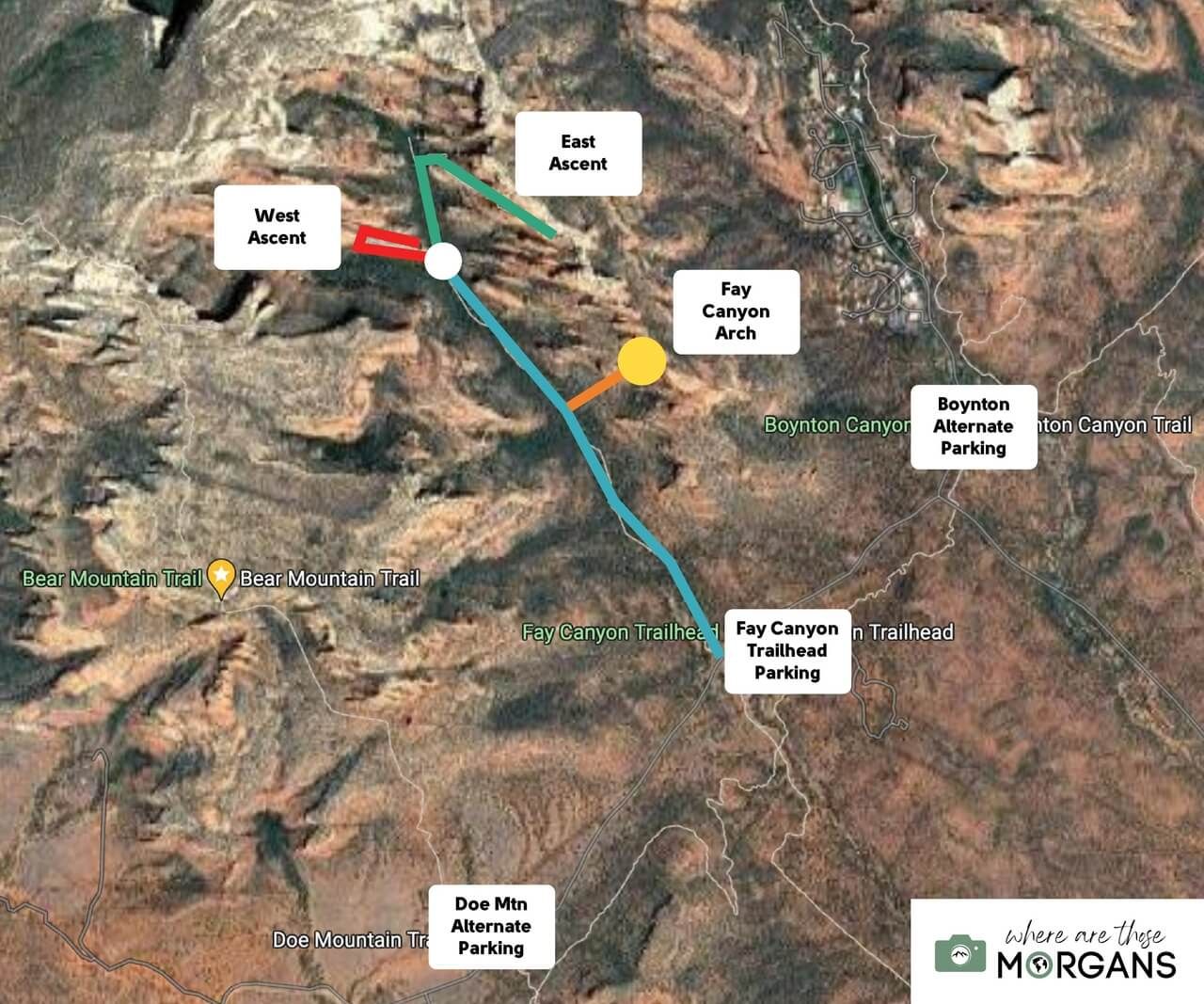
The map we created above shows exactly what you can expect when hiking Fay Canyon to the hidden arch and rock scrambles at the end of trail.
Map key:
- Blue Line – Fay Canyon Trail
- Orange Line – Climb to Fay Canyon Arch
- Yellow Circle – Fay Canyon Arch
- White Circle – End of maintained trail
- Red Line – West Ascent
- Green Line – East Ascent
Trail Walkthrough
Let’s get into our Fay Canyon hiking walkthrough. We’re going to show you the entire trail step-by-step so you know exactly what to expect.
1. Park At Fay Canyon Trailhead

Fay Canyon Trailhead has a huge parking lot with loads of spaces. You should be able to park here without too many issues most of the year.
On the southern end of Fay Canyon Trailhead parking lot you will find restrooms. Look for the sign stating Cockscomb Trail straight ahead and Fay Canyon to the right. Follow the right turn and cross the main road to begin the hike.
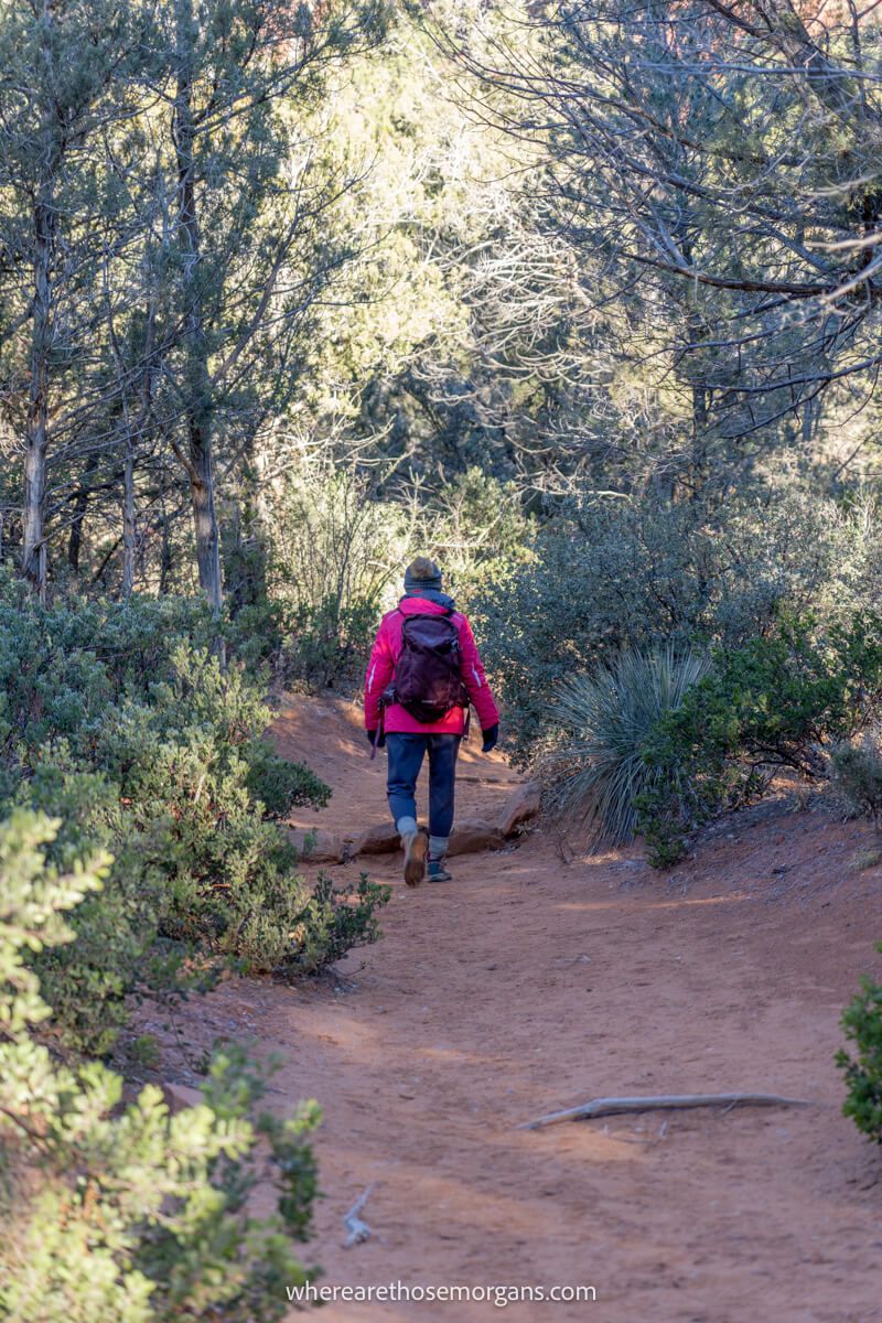
2. Begin Hiking Into Fay Canyon

Fay Canyon Trail is flat, easy and soft underfoot. Following the dirt packed path, you will walk through picturesque desert vegetation and juniper trees as you enter the canyon.
Keep your eyes on the red rock cliffs to your right side. Look for an arch shaped hole where the rock wall meets the top of the steep bank.
3. Find The Spur Trail

The photo above shows the exact point you will turn right off Fay Canyon Trail. This right spur trail leads through a dry creek at a right angle to the main trail. It’s a very obvious turn and you won’t miss it.
Only take the spur trail if you are comfortable with steep climbs and you have robust shoes on for the ascent. Take the rocky path leading out of the wash to the right side and look for the arch formation at the top of the bank.
4. Climb To Fay Canyon Arch

There are various lightly beaten trails you can take to climb up the steep bank. Try to find the most heavily beaten path and stick to it so you don’t disrupt the vegetation.
Fay Canyon Arch becomes clearer the closer you get to it. And as the arch becomes clearer, the bank gets even steeper! The final approach has loose stones and rocks so take care with your footing.
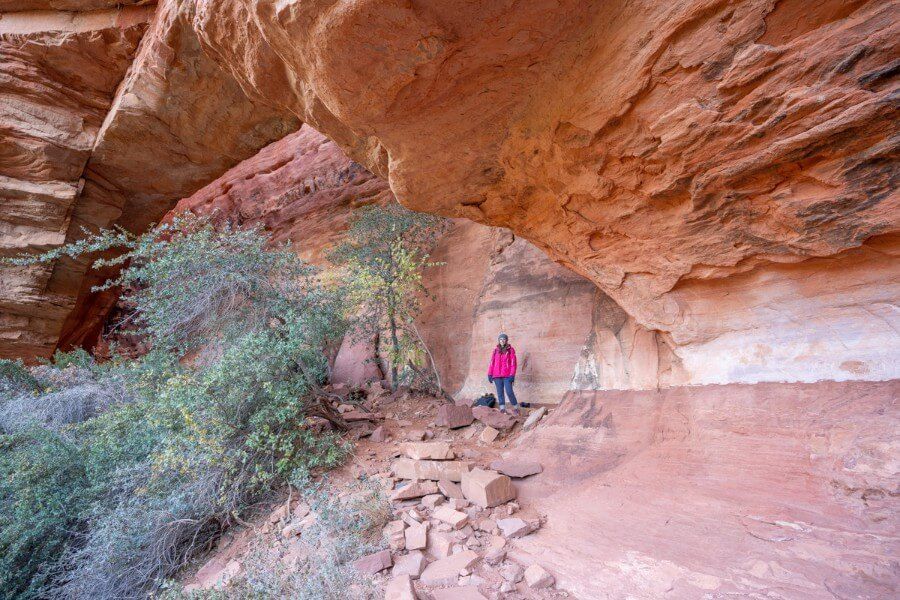
5. Look Up At The Arch
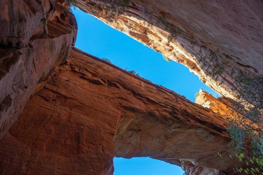
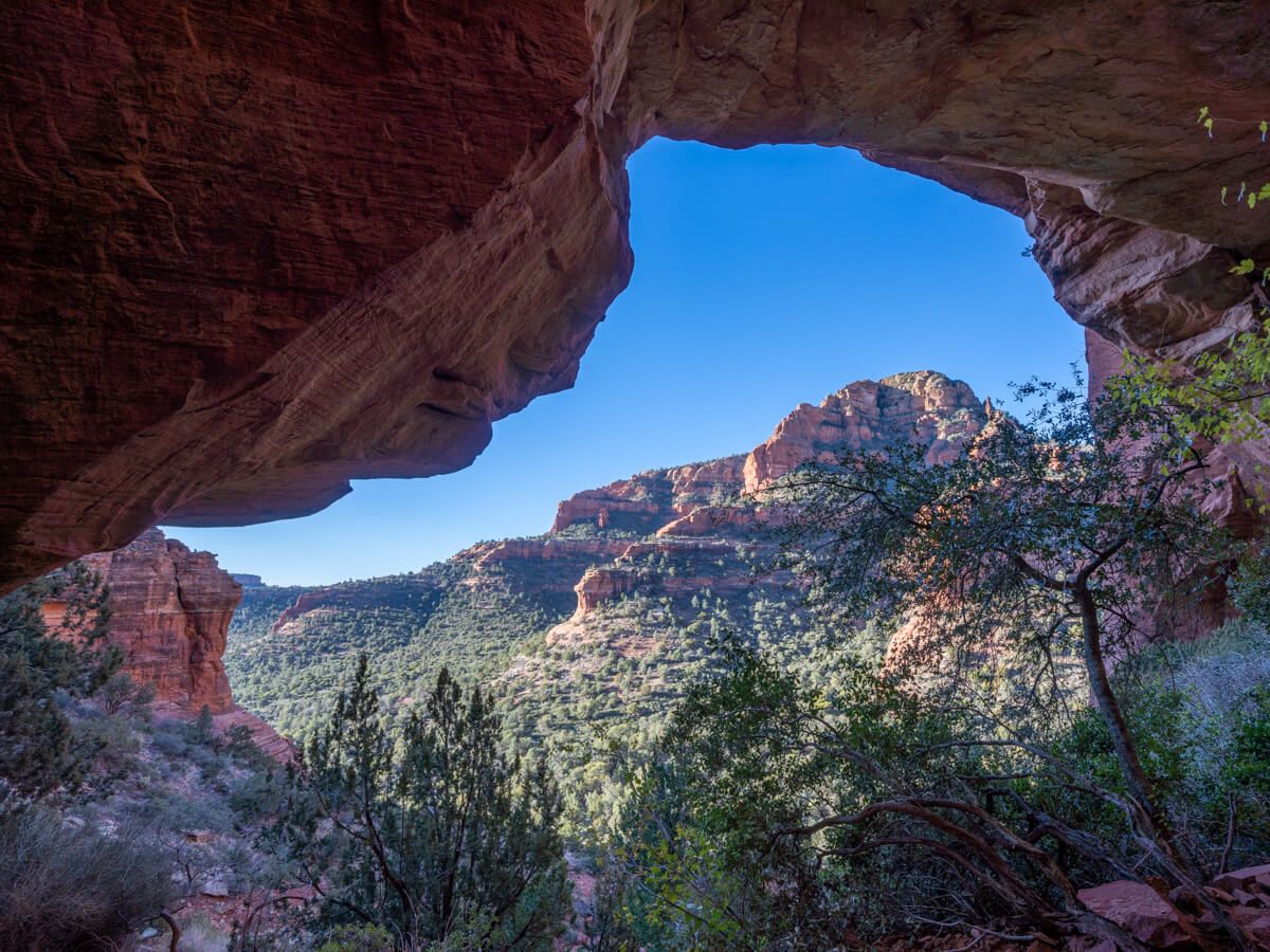
Once you summit the bank, stand directly underneath Fay Canyon Arch. Look up to see a surprisingly wide gap between the arch and the main red rock cliff wall behind.
The reverse face of Fay Canyon Arch is almost perfectly flat, as though it was sliced with a knife.
Need help planning your trip to Sedona?
Our Sedona travel guidebook gives you hidden gem hiking trails, secret caves, vortex sites, ancient ruins, wineries, jeep trails, photo spots, where to eat and stay, 1-5 day itinerary ideas and much more. Plus, you’ll get an exclusive map to use in Sedona!
View Guidebook
6. Walk Behind Fay Canyon Arch

You can walk a few feet behind the arch before reaching a dead end at the cliff. Look back to see the stunning view over Sedona through Fay Canyon Arch, which has a similar appearance to some of the nearby caves.
In late afternoon and early evening, the sun will burst through Fay Canyon Arch and the rocks would glow a deep orange color.
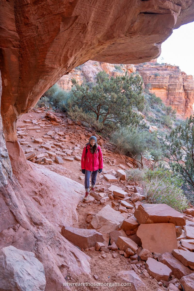
7. Continue To The End Of Trail Sign

Carefully descend the steep bank and take care with the loose stones. Turn right once you are back on Fay Canyon Trail and continue hiking until you see the tree with the end of trail sign as you can see in the photo above.
If you didn’t climb up to Fay Canyon Arch and you certainly don’t intend to rock scramble, this is the point for you to stop and turn back.
8. Choose East Or West Ascent
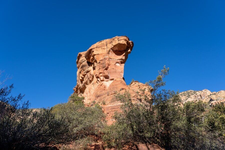
A few steps beyond the end of trail sign reveals a tall oddly shaped rock formation towering into the sky. This is what you can stand atop if you scramble up the West Ascent.
Now, you can either take on the West Ascent here or you can continue hiking due north on the unmaintained section of Fay Canyon Trail. After 0.2 miles you will reach a right turn which leads to the East Ascent.
9. Scramble To A Viewpoint

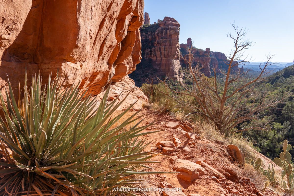
If you decide to take on the West Ascent like we did, you will begin by climbing slick rock and following a narrow ledge. Look for the piles of dirt that have collected in pockets of eroded rock.
Keep the tall cliff walls to your right side and hug the inside edge tightly. You will walk west and gain elevation on the narrow ledge until it switches back 180 degrees so you are heading east. Walk across the flat top until you get to the end.
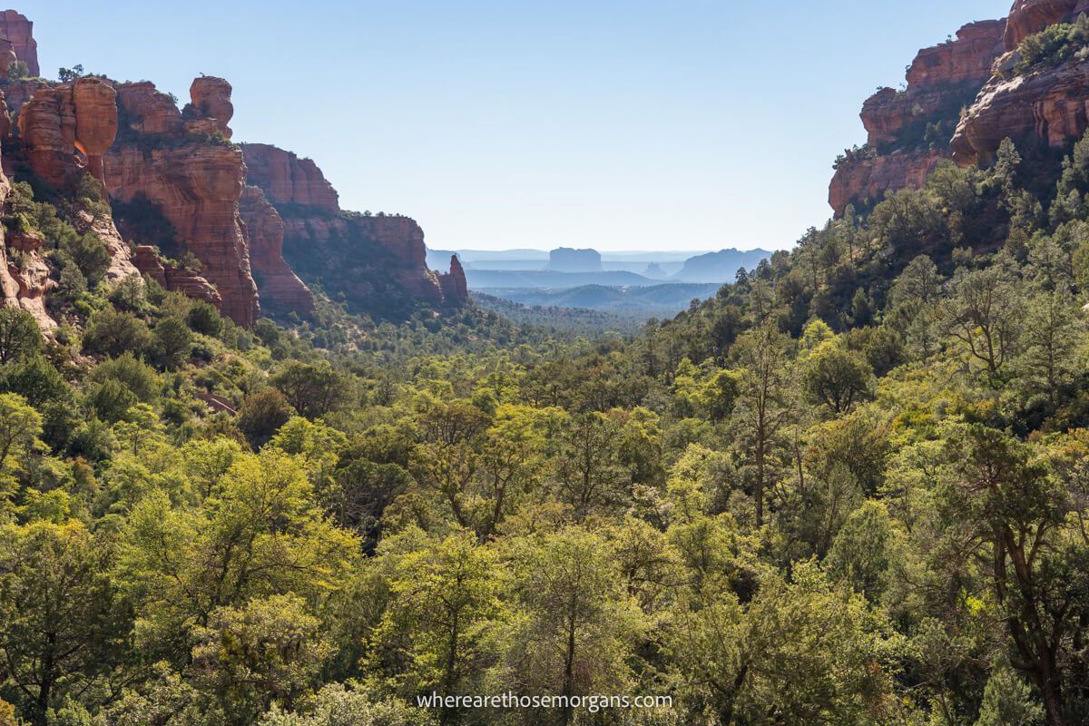
10. Enjoy The Views

From the top you can look back down through the U-shaped Fay Canyon, which we have to say is a fantastic photo op. However, it’s a southeast facing viewpoint so you will be looking directly into the sun if you hike in the morning like we did.
You can just about make out the iconic Bell Rock and Courthouse Butte formations in the far distance shrouded in haze in our photo above.
Hiking tip: You only have to climb up the very first part of West Ascent Trail to get above the tree line and open up spectacular canyon views.
11. Hike Back To The Trailhead

Once you’re all done with the amazing views over Fay Canyon, it’s time to head back to the parking lot. Take care descending from either the West or East Ascent trails.
The return leg will take no time at all, unless you hike back up to see Fay Canyon Arch one final time!
Pros And Cons
Here are our pros and cons to hiking Fay Canyon Trail in Sedona:
Pros:
✅ Easy flat hike with optional adventure elements
✅ Much larger parking lot than average for Sedona
✅ Perfectly located for hiking more nearby trails
Cons:
❌ Both the arch and end ascent are steep paths
❌ Not the most exciting hike if don’t include the arch or ascent
❌ Very busy trail from mid morning to mid afternoon
Fay Canyon Trailhead Parking

Fay Canyon Trailhead has its own parking lot on Boynton Pass Road. The parking area is larger than average for Sedona hikes but it can fill quickly because it is also used as a spillover for the nearby Boynton Canyon Trail.
Here’s the Google Maps location for Fay Canyon Trailhead.
Alternate Parking Options
If Fay Canyon Trailhead parking lot is full, try parking at nearby Doe Mountain or Boynton Canyon. Doe Mountain is your best bet as Boynton Canyon is extremely popular and has limited parking.
You can hike Aerie Trail from both Doe Mountain trailhead and Boynton Canyon trailhead to join Fay Canyon Trail:
- Doe Mountain to Fay Canyon Trailhead is 1.5 miles one way
- Boynton Canyon to Fay Canyon Trailhead is 1.2 miles one way
There are also places you can park on the roadside near Fay Canyon parking lot. Just make sure your vehicle is completely off the main road.
Do You Need A Parking Pass?
Yes, you need to display either a Red Rock Pass or America the Beautiful Interagency Pass on your vehicle dashboard to park at Fay Canyon Trailhead in Sedona.
You can buy a Red Rock Pass at this recreation.gov page in advance, or you can buy a pass at a ticket machine when you arrive in person.
Red Rock Pass options include:
- 1 Day Red Rock Pass – $5
- 7 Day Red Rock Pass – $15
- Red Rock Annual Pass – $20
Do you have an America the Beautiful National Parks Pass? You can use it instead of a Red Rock Pass at these trailheads, which includes Fay Canyon.
Best Time To Hike Fay Canyon Trail
The ideal to hike Fay Canyon Trail would be late afternoon on a weekday in spring or fall so you can benefit from perfect hiking and light conditions.
Sedona is busiest in spring and fall, which could lead to the Fay Canyon Trailhead parking lot filling up. So the temperatures will be perfect but it’ll also be crowded on the hike.
Summer and in particular winter are quieter periods in Sedona, which means you have more chance getting parked up at the trailhead without issue and enjoying the trail with fewer crowds. We hiked Fay Canyon in winter and it was quiet at the parking lot until around 10:00am.
The best time of day to hike Fay Canyon is late afternoon because Fay Canyon Arch will light up and you won’t be looking into the sun from the West Ascent summit.
However, early morning will be quieter and cooler so it’s another great time to hike. We had just hiked Doe Mountain Trail for sunrise before heading straight out into Fay Canyon around 8:00am. The light isn’t ideal in the morning but it’s much quieter.
What To Pack
- Footwear – Footwear with good grips and traction are essential for climbing the steep bank to Fay Canyon Arch but more importantly for the rock scramble ascent at the end.
- Water – You’ll be out hiking for anywhere between 1.5 to 3.5 hours in Fay Canyon, which means you’ll need to carry water. Summer months require more water and even electrolyte drinks.
- Sun protection – Sunglasses, sun hats, long layers and sunscreen are vital if you are visiting Sedona in summer. Most of the hike is shaded by trees but Fay Canyon Arch and the West Ascent climb are completely exposed.
- Winter – Early starts are cold in Sedona during winter. Even on sunny mornings like we had in December, we needed our coats, gloves and hats until it warmed up later in the morning.
Our Top 5 Tips
- Leave your car at Fay Canyon to hike Doe Mountain or Boynton Canyon to avoid parking issues
- Keep your eyes peeled for that right spur trail leading to Fay Canyon Arch
- You don’t need to climb the whole West Ascent to get those awesome canyon views
- Set off early to beat the crowds for a more relaxing hike
- Use a hiking app like Gaia GPS offline maps for navigation
The Morgan Conclusion

Fay Canyon Trail is one of the most popular hikes in Sedona. It can be hiked in many ways which makes it suitable for hikers of all ages and abilities. The trailhead has a large parking lot and it’s located close to other major Sedona hikes like Boynton Canyon and Doe Mountain.
Is Fay Canyon Trail worth it?
Yes! Fay Canyon Trail is short, scenic and perfect for groups with different hiking abilities. Stronger hikers can climb to Fay Canyon arch and a viewpoint at the end of the trail, while others relax on the main trail. It’s definitely one to include on your Sedona hiking itinerary!

Next Steps
We hope our Fay Canyon Trail guide helps with planning your trip to Sedona.
Don’t forget you can book a travel planning video call with us if you’d like our expert help organizing your trip to Sedona. We can answer any questions you have or walk through a personalized itinerary to make the most of your time.
Still researching for your trip?
- What to know about a first trip to Sedona
- Here are the top things to do in Sedona
- Here’s exactly where to stay in Sedona
- These are the unmissable hikes in Sedona
- Here’s our 1-5 days in Sedona itinerary
- This our ultimate 7-day Sedona itinerary
Finally, if you’ll be visiting more places on the same trip, we recommend reading our Arizona travel guide for more helpful tips and advice.
Happy Travels,
Mark and Kristen
Find this guide helpful? Pin it for later!


All Rights Reserved © Where Are Those Morgans, LLC. Republishing this article and/or any of its contents (text, photography, maps, graphics, etc.) in whole or in part is strictly prohibited.

Mark and Kristen spent 6 years traveling the world, visiting over 40 countries across 4 continents and more than 30 US states. They created Where Are Those Morgans in 2018 to help others plan the best possible vacations by writing authentic travel and hiking guides based on their real experiences.
Since the arrival of baby Maya in late 2024, Mark and Kristen’s extensive travels have slowed down but they still take plenty of trips. Where Are Those Morgans now helps millions of travelers each year to visit new places and hike new trails through information-packed blog posts and expert travel guidebooks. Read more about Mark and Kristen.
Thank you for posting such a thorough description!
Thanks so much for reading Ron and have a great hike!