Cave Rock Trail is an easy 0.8-mile roundtrip hike with 120 feet elevation change on the southeastern shores of Lake Tahoe, Nevada. It takes about 15 minutes to reach Cave Rock on a gradual dirt packed path, then there’s a steep summit climb on uneven rocks, so we recommend wearing robust shoes. We hiked to Cave Rock to watch a famous Lake Tahoe sunset, but we had mixed results!
In this guide we walk you step-by-step through hiking to Cave Rock in Lake Tahoe, based on our own experiences. Read more about us.
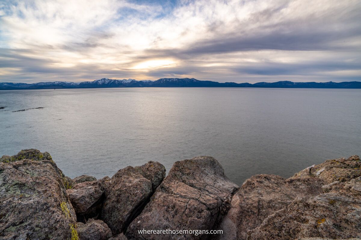
Cave Rock was among our top sunset photography targets during our 6 day trip to Lake Tahoe in November 2021. We hiked to the rocky summit around one hour before sunset so we could find the perfect spot and get ready to watch a stunning spectacle. But the weather had other ideas!
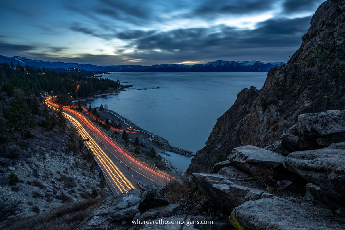
It wasn’t rain or snow, it was the wind. We couldn’t get any tripod and camera stability for long exposures and it got to a point when we didn’t feel safe at the top. So we took shelter behind the Cave Rock summit rock, and we still enjoyed watching the sunset. Okay, let’s begin!
Note: Our content is reader supported and contains affiliate links. If you make a purchase through one of these links, we may earn a small commission at no extra cost to you and it helps us keep this site running.
What Is Cave Rock?
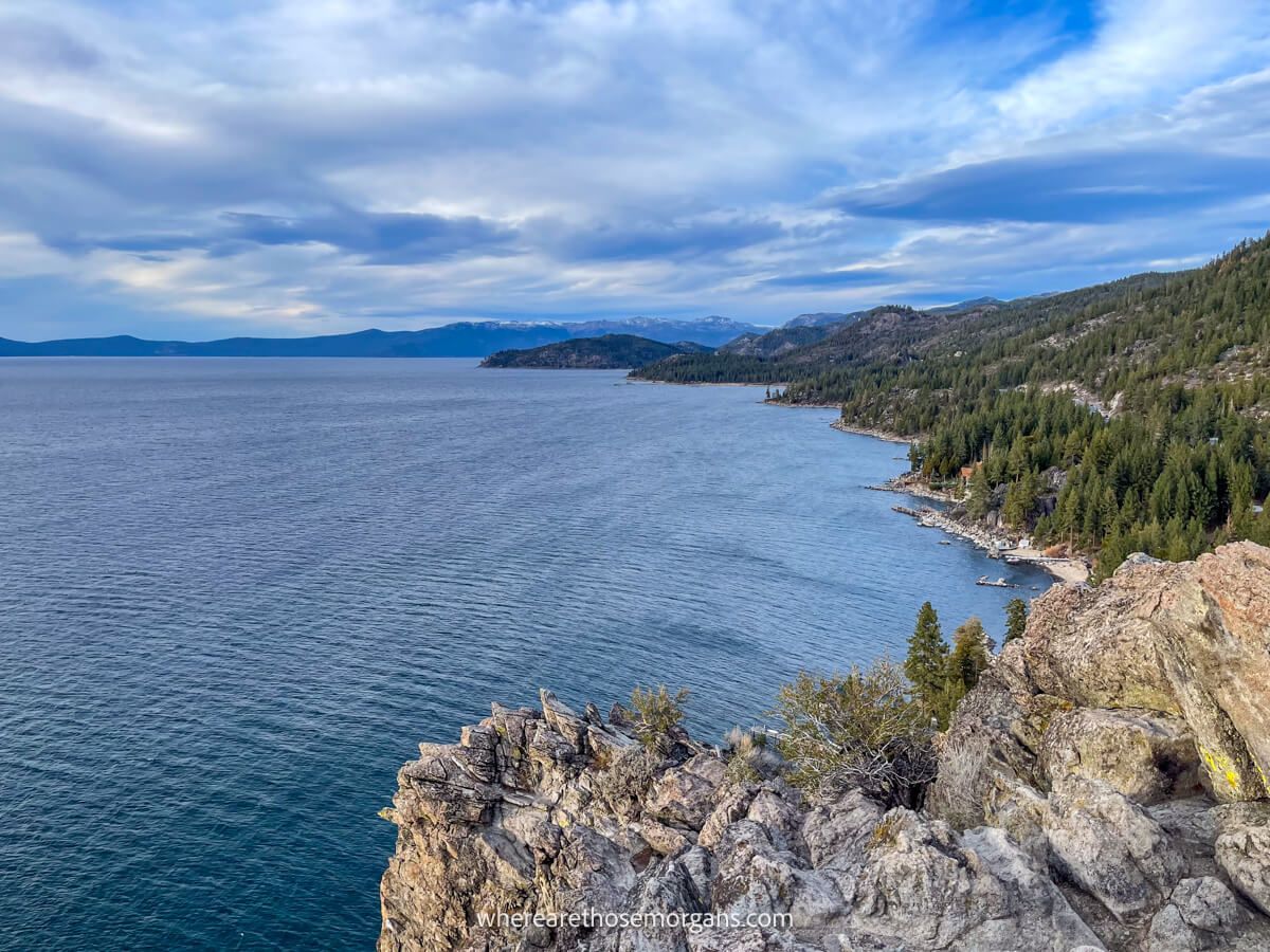
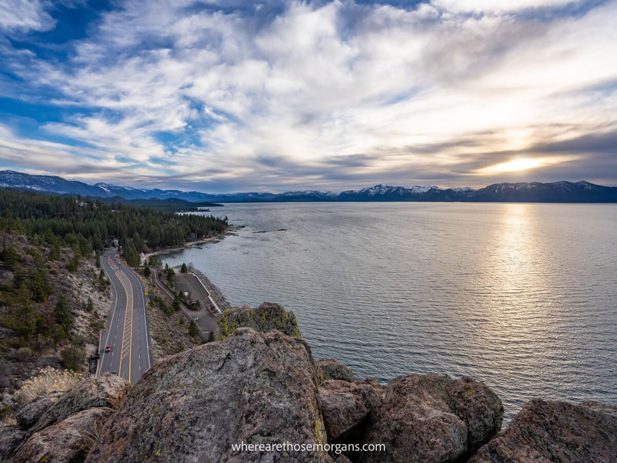
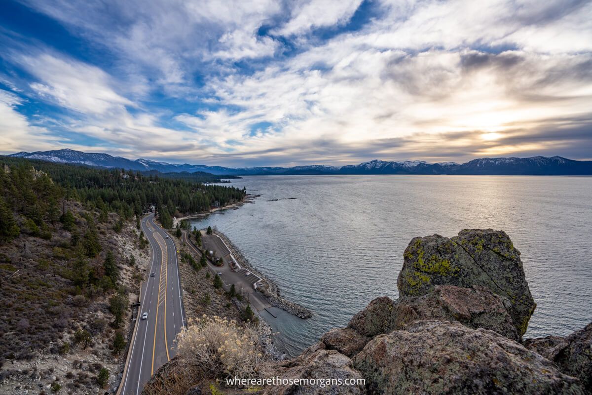
Before we get into the hike, we wanted to quickly explain what you’ll be hiking to! Cave Rock is a tall and wide rock formation that’s unique because it bursts into the sky directly from the shoreline of Lake Tahoe. And instead of building the highway around the towering formation, the road was built through a tunnel at the base of the rock.
The summit of Cave Rock is one of the tallest points along Lake Tahoe’s immediate shoreline and it has completely unobstructed 360 degree views. If you kayak out into the lake and look back at the shoreline, you’ll see Cave Rock looks a bit like a gigantic baseball glove raised high in the air ready to catch a near home-run.
Trail Information
- Distance: 0.8 miles roundtrip
- Elevation gain: 120 feet
- Time: 30 minutes
- Difficulty: Easy
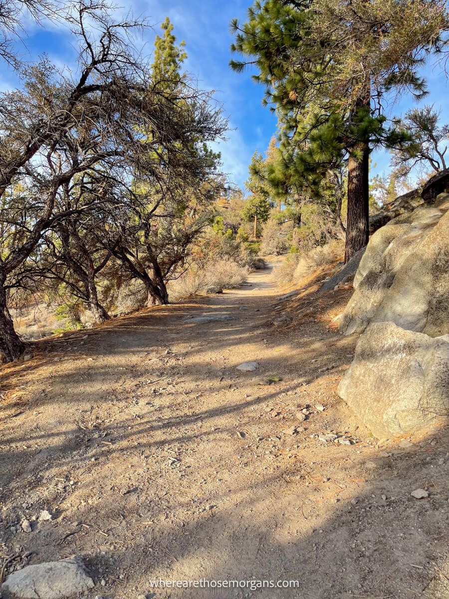
Cave Rock Trail is a very easy hike until you reach the short but steep and uneven rocky climb at the end. Take your time and use your hands to help with climbing up or down some of the steeper sections if necessary. It was windy when we climbed the rock so we were very careful with foot placements!
FEES: Visiting Sand Harbor, Spooner Lake or Cave Rock in Lake Tahoe Nevada State Park will cost you $10 for NV vehicles or $15 for non-NV vehicles. But there is no fee to park at Cave Rock Trailhead because you only have to pay when parking in the boat launch area on the side of Highway 50.
Cave Rock Trailhead Parking
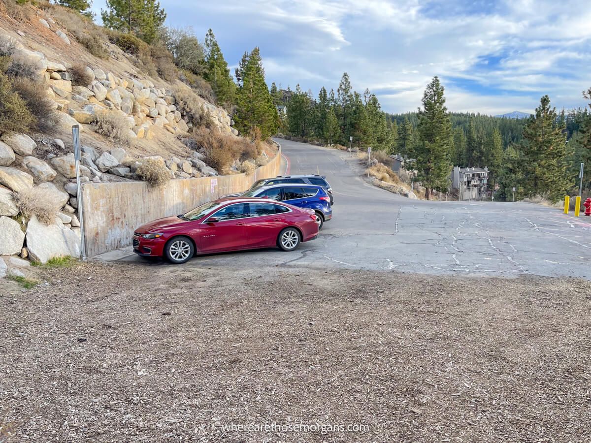
Parking to hike Cave Rock Trail is going to be your biggest problem because spaces are extremely limited. There are just three designated parking spots with white lines, but there’s also room for one or maybe two cars at the most on a dirt packed hard shoulder next to the road.
To reach trailhead parking:
- Turn off Highway 50 onto Cave Rock Drive
- Drive 0.2 miles until you reach a sharp right hairpin turn
- Go straight at the hairpin to enter the small trailhead parking lot
Only from this exact trailhead can you hike to the popular Cave Rock sunset viewpoint. Here’s the Google Maps location to open in your GPS navigation.
We were lucky to get one of the three parking spots when we arrived a little more than one hour before sunset. And it’s only because hiked it in mid-November. If you really want to see a sunset from Cave Rock when you visit Lake Tahoe, we strongly recommend you plan to arrive at the trailhead at least 2 hours before sunset.
Hiking To Cave Rock
We’re going to walk you through the hike exactly as it was for us so you know what to expect:
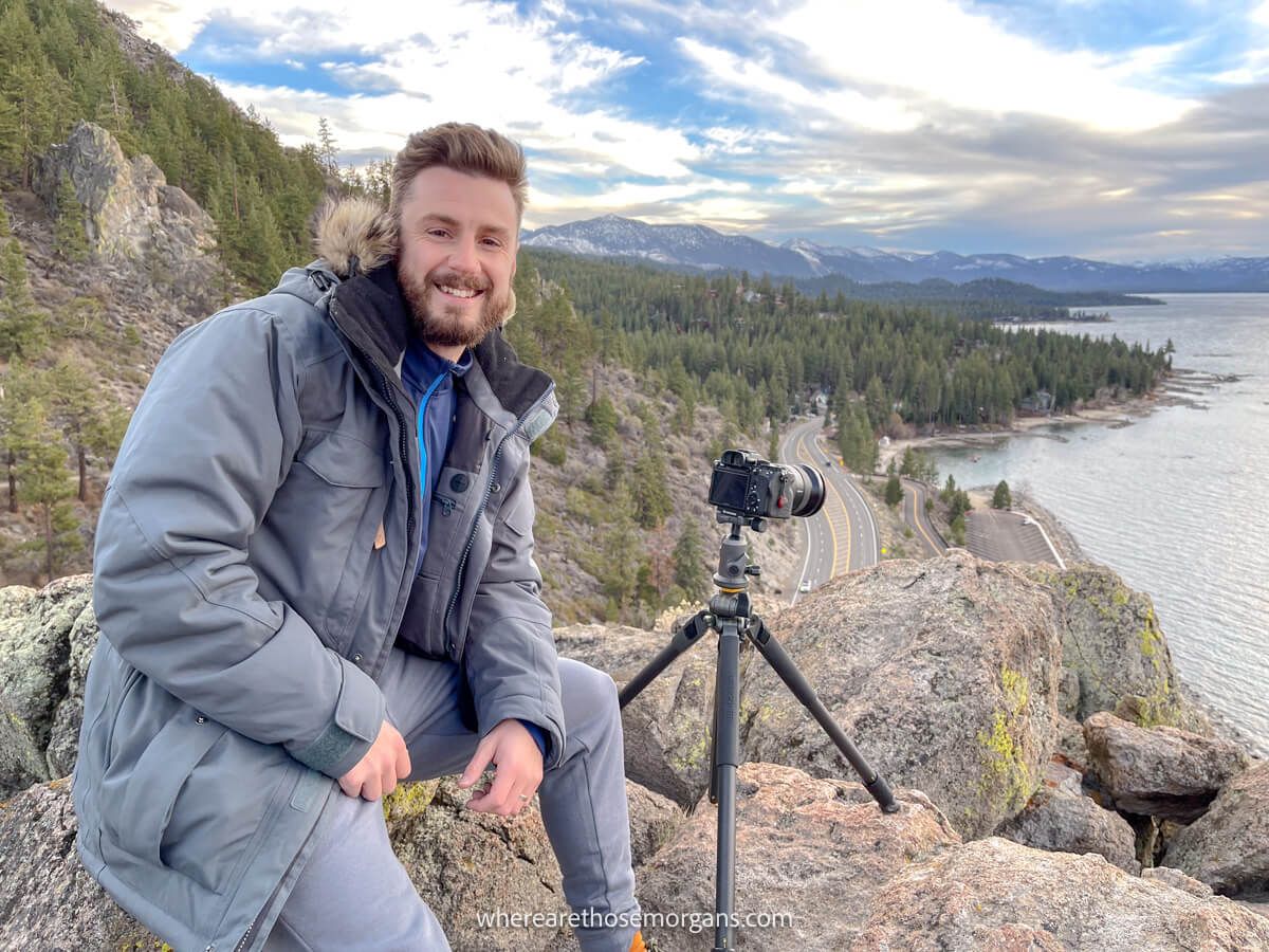
1. We parked in the last remaining space, switched into our hiking boots, grabbed our winter coats and packed headlamps in our day pack ready for the dark hike back. Mark also had our tripod strapped over one shoulder and our camera strapped over the other.
2. Next, we set off on the gradually inclining dirt path and followed it for 0.3 miles. It had lovely views over Lake Tahoe through gaps in trees to the left side and it was very dusty but easy going. Before long we could see what looked like a mound extending out to the left side, so we took a dirt path to it.
3. Finally we climbed up the mound to its summit, which turned out to be made up of sharp and jagged rocks. It was difficult to find a comfortable place to sit and set up our tripod. But it didn’t matter anyway because the wind was so strong and the sunset was disappointing. So we climbed back down and found a sheltered spot to try long exposures with car light trails once it got darker.
Route Map
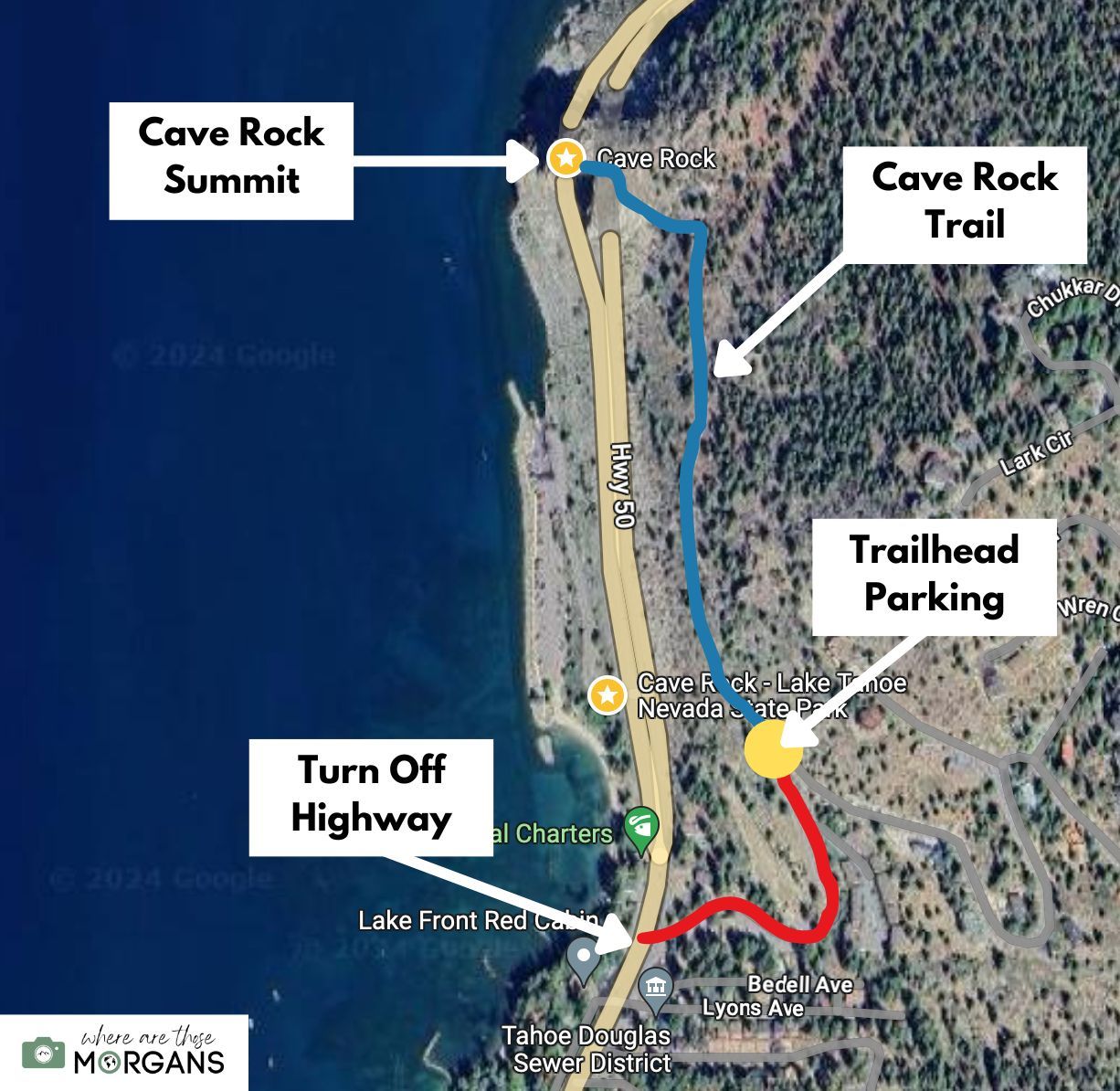
Use the map we created above to orientate yourself with the layout of the land around Cave Rock. As long as you can get parked up, the hike is really easy and straightforward.
Map key:
- Red – Cave Rock Road
- Yellow – Trailhead parking
- Blue – Cave Rock Trail
Cave Rock Sunset Photography
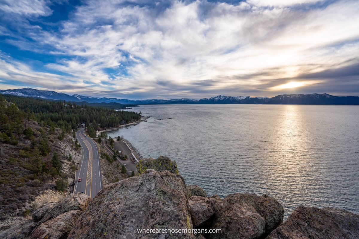
Sunset is the most popular time of day to hike Cave Rock because it has unobstructed west facing views. And on days when the weather and clouds are playing nicely, we think Cave Rock is one of the best Lake Tahoe sunset spots. Frustratingly, we had an amazing sunset the night before and the night after we hiked Cave Rock.
Don’t forget to charge your smartphone, GoPro and camera, clear your SD cards and bring your tripod. The summit is very rocky, so you might need to adjust your tripod legs to find stability. We highly recommend waiting for 30 minutes after sunset so you can take cool long exposures with car light trails as they enter and leave the tunnel below you.
Leave No Trace
Please take great care not to disturb formations, vegetation or wildlife when you hike to Cave Rock in Lake Tahoe. It’s a beautiful place to visit and we all have to keep it that way for future generations to enjoy.
Remember and follow these 7 principles of leave no trace:
- Plan ahead and prepare
- Travel and camp on durable surfaces
- Dispose of waste properly
- Leave what you find
- Minimize campfire impacts
- Respect wildlife
- Be considerate of others
Best Time To Hike
We think the best time to hike Cave Rock Trail is for sunset on a weekday in spring or fall. That way you’d benefit from the best light conditions and fewer crowds. Just remember to take a headlamp for your hike back up the steep bank after sunset. It’s a good idea to read recent comments from other hikers in the days leading up to your visit to see current conditions.
Because we visited Lake Tahoe in November, we were able to get a coveted parking spot close to sunset. But if you’re visiting in a busier month, you might want to consider either arriving 2 hours before sunset, or giving up on sunset entirely to avoid the stress of getting parked. Sunrise would also make a fantastic time to summit Cave Rock and you’d have a much better chance getting a parking space.
What To Pack
To reach Cave Rock summit you’ll have to climb up and back down a steep hill with sharp rocks. In good conditions it isn’t essential to wear serious hiking gear but we recommend wearing a sturdy pair of shoes or boots with good tread. It’s a short hike so you won’t need to carry snacks, but you should always carry plenty of water, especially if you hike it during the day in summer.
In terms of camera gear, you’ll need a tripod and you might want to attach either a polarizing filter or a ND filter depending on your style of photography. Don’t forget to carry a headlamp and keep your smartphone charged so you can use the flashlight on the way back to your car.
More Hikes In The Area
Are you planning to hike as many trails as possible during your visit to Lake Tahoe? Here are some of our favorite hikes for you to try in the area:
- Mt Tallac Trail
- Eagle Rock Trail
- Monkey Rock Trail
- Chimney Beach Trail
- Castle Rock Trail
- Bonsai Rock Trail
- Eagle Falls Trail
- Tahoe Rim Trail
The Morgan Conclusion
We think Cave Rock is a must-visit sunset spot for photographers, hikers and anyone who enjoys nature. Limited parking is going to be your major concern, so factor that in if you want to visit for sunset. The hike is easy but the final climb can be challenging, so it’s important to take your time.
For us, Cave Rock provides the perfect opportunity to relax, watch a serene sunset over Lake Tahoe, and maybe even pull out a small bottle of wine to enhance the overall experience. As long as the weather is fine of course!
Want more California content? Head over to our California Travel Guides to explore national parks, popular road trips and things to do in major cities of the sunshine state.
We hope our guide to hiking Cave Rock Trail helps with planning your trip to Lake Tahoe!
Please let us know if you have any questions in the comments below.
Happy Hiking,
Mark and Kristen
Enjoy this guide? Pin it for later!
All Rights Reserved © Where Are Those Morgans, LLC. Republishing this article and/or any of its contents (text, photography, maps, graphics, etc.) in whole or in part is strictly prohibited.

Mark and Kristen spent 6 years traveling the world, visiting over 40 countries across 4 continents and more than 30 US states. They created Where Are Those Morgans in 2018 to help others plan the best possible vacations by writing authentic travel and hiking guides based on their real experiences.
Since the arrival of baby Maya in late 2024, Mark and Kristen’s extensive travels have slowed down but they still take plenty of trips. Where Are Those Morgans now helps millions of travelers each year to visit new places and hike new trails through information-packed blog posts and expert travel guidebooks. Read more about Mark and Kristen.
Thank you for the information on Cave Rock. We did this hike today, mid day. We were lucky and got one of the 4 parking spots. The hike up the “rock” wasn’t to bad, for two 65+ old people, but the hike down was a little challenging. We just took it slow, watched our footings and slid down a couple areas. The views were amazing. So glad we did it, and would recommend it to others.
Hi Deb, glad to hear you enjoyed hiking Cave Rock. It is definitely one of the better short hikes around Lake Tahoe but we agree the descent should be taken slowly and carefully.